| Revision as of 04:26, 10 September 2009 editDr. Dan (talk | contribs)Autopatrolled, Extended confirmed users, Pending changes reviewers8,342 editsNo edit summary← Previous edit | Revision as of 04:43, 10 September 2009 edit undoJacurek (talk | contribs)9,609 edits - important content restored.Next edit → | ||
| Line 1: | Line 1: | ||
| ] | ] | ||
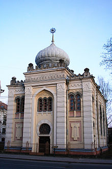
| ] ] in Žvėrynas ]] | ] ] in Žvėrynas (Polish: ''Zwierzyniec'').]] | ||
| '''Žvėrynas,''' literally ''the ]'' is one of the older neighborhoods in ], ]. It lies on the banks of the ] River, and is situated to the west of the Lithuanian ] (]) building. The river surrounds it from three sides and isolates it from the city. On the other side of the river, to the northwest, lies ]. | '''Žvėrynas,''' ({{lang-pl|Zwierzyniec}}), literally ''the ]'' is one of the older neighborhoods in ], ]. It lies on the banks of the ] River, and is situated to the west of the Lithuanian ] (]) building. The river surrounds it from three sides and isolates it from the city. On the other side of the river, to the northwest, lies ]. | ||
| Originally the district belonged to the ] family, who maintained wild animals in the area for hunting purposes (hence the name). In 1825, a summer house was built which later became the residence of the ] of the ]. At the end of the 19th century, Žvėrynas became the property of businessmen who in turn sold individual tracks of land to the city's residents. In 1901, it was incorporated into the city. Žvėrynas was the first planned neighborhood with straight streets and rectangular blocks. It remained mostly residential with very few industrial enterprises. After Lithuania regained its independence in 1990, Žvėrynas became one of its more prestigious neighbourhoods. | Originally the district belonged to the ] family, who maintained wild animals in the area for hunting purposes (hence the name). In 1825, a summer house was built which later became the residence of the ] of the ]. At the end of the 19th century, Žvėrynas became the property of businessmen who in turn sold individual tracks of land to the city's residents. In 1901, it was incorporated into the city. Žvėrynas was the first planned neighborhood with straight streets and rectangular blocks. It remained mostly residential with very few industrial enterprises. After Lithuania regained its independence in 1990, Žvėrynas became one of its more prestigious neighbourhoods. | ||
Revision as of 04:43, 10 September 2009


Žvėrynas, (Template:Lang-pl), literally the menagerie is one of the older neighborhoods in Vilnius, Lithuania. It lies on the banks of the Neris River, and is situated to the west of the Lithuanian Parliament (Seimas) building. The river surrounds it from three sides and isolates it from the city. On the other side of the river, to the northwest, lies Vingis Park. Originally the district belonged to the Radziwiłł family, who maintained wild animals in the area for hunting purposes (hence the name). In 1825, a summer house was built which later became the residence of the Governor General of the Vilna Governorate. At the end of the 19th century, Žvėrynas became the property of businessmen who in turn sold individual tracks of land to the city's residents. In 1901, it was incorporated into the city. Žvėrynas was the first planned neighborhood with straight streets and rectangular blocks. It remained mostly residential with very few industrial enterprises. After Lithuania regained its independence in 1990, Žvėrynas became one of its more prestigious neighbourhoods.
Žvėrynas is also an elderate within the Vilnius city municipality. According to the 2001 census, about 12,000 people live within a 2.7 km² area. That makes it the second smallest elderate in the municipality. Žvėrynas has a great number of government and educational institutions, finance and insurance companies, as well as health care institutions.
Žvėrynas is the site of Vilnius' only kenesa.
External links
- Discussion thread with lots of photos
- Map of Žvėrynas
- Wooden Architecture of Vilnius Historic Suburbs
- Žvėrynas Community Homepage Template:Lt icon
| Vilnius | |||
|---|---|---|---|
| History | |||
| Elderships | |||
| Government | |||
| Transport | |||
| Education | |||
| Landmarks | |||
54°41′32″N 25°15′0″E / 54.69222°N 25.25000°E / 54.69222; 25.25000
This Lithuanian location article is a stub. You can help Misplaced Pages by expanding it. |