| Revision as of 09:46, 19 April 2021 editRioHondo (talk | contribs)Autopatrolled, Extended confirmed users55,241 edits removed Category:Geography of Agusan del Sur using HotCat← Previous edit | Revision as of 11:46, 1 May 2021 edit undoJules Aguila (talk | contribs)Extended confirmed users512 editsm →GeographyTag: Visual editNext edit → | ||
| Line 67: | Line 67: | ||
| ''Boguko River'' is situated approximately 8.779840, 125.711982 in the island of ].<ref name=":0" /><ref>{{Cite web|title=GeoHack - Boguko River|url=https://geohack.toolforge.org/geohack.php?language=ceb&pagename=Boguko_River¶ms=8.779840_N_125.71198_E_type:river_region:|access-date=2021-04-17|website=geohack.toolforge.org}}</ref> Terrain elevation at these coordinates is estimated 719 metres above seal level. | ''Boguko River'' is situated approximately 8.779840, 125.711982 in the island of ].<ref name=":0" /><ref>{{Cite web|title=GeoHack - Boguko River|url=https://geohack.toolforge.org/geohack.php?language=ceb&pagename=Boguko_River¶ms=8.779840_N_125.71198_E_type:river_region:|access-date=2021-04-17|website=geohack.toolforge.org}}</ref> Terrain elevation at these coordinates is estimated 719 metres above seal level. | ||
| ''Boguko River'' headwaters originate from the ] of Barangays Banagbanag and New Tubigon where its mouth located in Barangay Magsaysay joins with the larger ]. Wawa River is the largest and longest river in the town and a tributary river to the ].<ref>{{Cite web|title=The Mighty Rivers of Agusan {{!}} Len Joson|url=https://lenjoson.com/the-mighty-rivers-of-agusan/|access-date=2021-04-17|language=en-US}}</ref> | ''Boguko River'' headwaters originate from the ] of Barangays Banagbanag and ] where its mouth located in Barangay Magsaysay joins with the larger ]. Wawa River is the largest and longest river in the town and a tributary river to the ].<ref>{{Cite web|title=The Mighty Rivers of Agusan {{!}} Len Joson|url=https://lenjoson.com/the-mighty-rivers-of-agusan/|access-date=2021-04-17|language=en-US}}</ref> | ||
| == Crossings == | == Crossings == | ||
Revision as of 11:46, 1 May 2021
River in Caraga, Philippines| Boguko River | |
|---|---|
| File:Boguko River.jpgBoguko River in Sibagat, Agusan del Sur | |
 | |
| Native name | Ilog Boguko Error {{native name checker}}: parameter value is malformed (help) |
| Location | |
| Country | Philippines |
| Region | Caraga |
| Province | Agusan del Sur |
| Municipality | Sibagat |
| Physical characteristics | |
| Source | |
| • location | Sibagat, Agusan del Sur, Caraga Region |
| Mouth | Wawa River |
| • location | Magsaysay, Sibagat, Agusan del Sur |
| • coordinates | 8°46′47.4″N 125°42′43.1″E / 8.779833°N 125.711972°E / 8.779833; 125.711972 |
| Length | 10 km (6.2 mi) |
| Basin size | 8 km (3.1 sq mi) |
| Discharge | |
| • location | Wawa River |
| • average | 38 m/s (1,300 cu ft/s) |
| Basin features | |
| Progression | Boguko–Wawa–Agusan |
Boguko River (Template:Lang-tl; Template:Lang-ceb) is a stream located in Sibagat, Agusan del Sur, Caraga Region, Philippines. It is a tributary of the larger Wawa River with headwaters located in the mountain boundaries of Sibagat and the Province of Surigao del Sur.
Etymology
Boguko River got its name from the native word "bagako" which means mysterious. According to the oral history from early inhabitants of the place, mostly manobo natives, the place where the river is located had made few stories of mysterious disappearance of people and animals that's why they called the place as Bagako River which means "mysterious river". Variant forms of names and spelling of Bagako River or in other native languages such like Bagoko and its present name Boguko River.
Geography
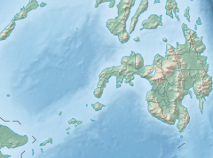
Boguko River is situated approximately 8.779840, 125.711982 in the island of Mindanao. Terrain elevation at these coordinates is estimated 719 metres above seal level.
Boguko River headwaters originate from the Diwata Mountain Range of Barangays Banagbanag and New Tubigon where its mouth located in Barangay Magsaysay joins with the larger Wawa River. Wawa River is the largest and longest river in the town and a tributary river to the Agusan River.
Crossings
In early years, a logging company operating on that area constructed an access road and built a highly elevated detour bridge that crossed Boguko River and they named it "Boguko Bridge". The bridge connects the villages of Sitio San Roque of Barangay Magsaysay to Sitio Kahayag of Barangay Banagbanag. The said access road and bridge are now part of the Butuan-Kolambugan-Tandag Road.
See also
- Agusan River
- Wawa River (Agusan del Sur)
- Andanan River
- Sibagat River
- Sibagat, Agusan del Sur
- Agusan del Sur Province
- List of rivers of the Philippines
References
- ^ "Boguko River,". philippines123.com. Retrieved 2021-04-17.
- "GeoHack - Boguko River". geohack.toolforge.org. Retrieved 2021-04-17.
- "The Mighty Rivers of Agusan | Len Joson". Retrieved 2021-04-17.
- "2nd Phase of Butuan-Tandag Road Construction Underway". Retrieved 2021-04-14.