| Revision as of 18:31, 28 October 2008 editDerry Boi (talk | contribs)7,524 edits ?← Previous edit | Revision as of 19:51, 28 October 2008 edit undoMooretwin (talk | contribs)Extended confirmed users25,613 edits Undid revision 248241752 by Derry Boi (talk)placed in order of national prominenceNext edit → | ||
| Line 54: | Line 54: | ||
| == Sport == | == Sport == | ||
| ⚫ | *] | ||
| *], which plays in the ] | *], which plays in the ] | ||
| ⚫ | *] | ||
| *]] | *]] | ||
Revision as of 19:51, 28 October 2008
Human settlement in Northern IrelandCoagh
| |
|---|---|
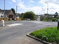
 Looking towards the village, from the County Londonderry side. Looking towards the village, from the County Londonderry side. | |
| Population | Expression error: "545 (2001 Census)" must be numeric |
| Irish grid reference | H8978 |
| • Belfast | 45 miles |
| District | |
| County | |
| Country | Northern Ireland |
| Sovereign state | United Kingdom |
| Post town | COOKSTOWN MAGHERAFELT |
| Postcode district | BT80 BT45 |
| Dialling code | 028 |
| Police | Northern Ireland |
| Fire | Northern Ireland |
| Ambulance | Northern Ireland |
| UK Parliament | |
| NI Assembly | |
| |

Coagh (Template:PronEng, from Irish An Uiach 'cup-shaped hollow') is a small village in County Tyrone, Northern Ireland, situated five miles (8 km) east of Cookstown. Part of the village also extends into County Londonderry. It had a population of 545 people in the 2001 Census. It owes its existence to George Butle Conyngham,and was founded in 1728 when King George II granted Conyngham a market charter allowing the village to host 4 fairs per year. The name derives from 'an uiach' meaning 'a cup-shaped hollow' as the village nestles among gentle low lying land between the Sperrins and Lough Neagh.
The main feature of the village is Hanover Square, which was named after the reigning Hanoverian King George II by Conyngham. The village has been an ancient settlement for several thousand years, overlooking Coagh is Tamlaght Stone a mesolithic dolmen erected circa 4,500BC.
History
The Troubles
For more information see The Troubles in Coagh, which includes a list of incidents in Coagh during the Troubles resulting in two or more fatalities.
The first attack of the Troubles came on 5 December 1971 when the IRA launched a mortar attack on the village police station.
Two further 500lb (227 kg) IRA bombs were planted at the front of the police station during the 1970s. On 7 September 1988 a 1,000lb (454 kg) van bomb exploded destroying the base and adjacent houses etc.
26 April 1988 - Edward Gibson (22) a Protestant, was shot and killed by the Irish Republican Army while working as a bin man, Moortown, near Ardboe, County Tyrone.
On the 24 November 1988 Phelim McNally was killed by Ulster Volunteer Force during a gun attack on the home of his brother, a Sinn Féin Councillor, Derrychrin Road, Ballinderry (near Coagh), County Tyrone.
7 March 1989 - Leslie Dallas (38) an Ulster Volunteer Force (UVF) leader, Austin Nelson (62) and Ernest Rankin (72), all Protestant civilians, were shot and killed by the Provisional Irish Republican Army at Leslie Dallas's garage in Hanover Square, Coagh.
29 November 1989 - Liam Ryan (39), the Commanding Officer of the East Tyrone Brigade of the Provisional Irish Republican Army and Michael Devlin (33), a Catholic civilian were shot dead during an Ulster Volunteer Force gun attack on the Battery Bar, Moortown, six miles (10 km) from Coagh.
09 April 1991 - Derek Ferguson (31), a Protestant civilian was killed by the Irish Republican Army at his mobile home, Aughaveagh Road, Coagh, County Tyrone. Derek was with two of his sons when the shooting took place.
3 June 1991 - Pete Ryan (35), Lawrence McNally (39) and Anthony Doris (22), all Catholic members of the Provisional Irish Republican Army, were shot and killed during an ambush by undercover British Army members from the SAS. All three men were armed and on active service at the time.
Education
Coagh has its own primary school, Coagh Primary School. This school is a feeder for many local schools including Cookstown High School
Sport
- Coagh United Football Club, which plays in the IFA Championship
- CLG Ogra Colmcille
- Coagh Angling Club]
Amenities
Coagh has a surgery which serves local areas, such as Ardboe, Ballinderry, Moortown, Drumullan, The Loup and Moneymore.
2001 Census
Coagh is classified as a small village or hamlet by the NI Statistics and Research Agency (NISRA) (ie with population between 500 and 1,000 people). On Census day (29 April 2001) there were 545 people living in Coagh. Of these:
- 20.9% were aged under 16 and 20.4% were aged 60 and over
- 48.3% of the population were male and 51.7% were female
- 26.4% were from a Catholic background and 72.8% were from a Protestant background
- 2.3% of people aged 16-74 were unemployed.
For more details see: NI Neighbourhood Information Service
References
- Ed Moloney, Secret History of the IRA, p.321, Brendan O'Brien, The Long War, p314
List of Doctors in Magherafelt area