| Revision as of 19:53, 4 March 2010 editIaaasi (talk | contribs)Extended confirmed users3,462 edits Hungarian name not relevant← Previous edit | Revision as of 20:17, 4 March 2010 edit undoIaaasi (talk | contribs)Extended confirmed users3,462 editsNo edit summaryNext edit → | ||
| Line 20: | Line 20: | ||
| }} | }} | ||
| The '''Southern Carpathians''' ({{lang-ro|Carpaţii Meridionali}}), also called the '''Transylvanian Alps''', are a group of ]s which divide central and southern ], on one side, and ], on the other side<ref></ref>. They cover part of the ] that is located between the ] in the east and the ] and ] Rivers in the west. To the south they are bounded by the ] of ]. | The '''Southern Carpathians''' ({{lang-ro|Carpaţii Meridionali}}, {{lang-de|Transsilvanischen Alpen}}), {{lang-hu|Déli-Kárpátok}}), also called the '''Transylvanian Alps''', are a group of ]s which divide central and southern ], on one side, and ], on the other side<ref></ref>. They cover part of the ] that is located between the ] in the east and the ] and ] Rivers in the west. To the south they are bounded by the ] of ]. | ||
| ==Heights== | ==Heights== | ||
Revision as of 20:17, 4 March 2010
The Southern Carpathians (Template:Lang-ro, Template:Lang-de), Template:Lang-hu), also called the Transylvanian Alps, are a group of mountain ranges which divide central and southern Romania, on one side, and Serbia, on the other side. They cover part of the Carpathian Mountains that is located between the Prahova River in the east and the Timiş and Cerna Rivers in the west. To the south they are bounded by the Balkan mountain range of Serbia.
Heights

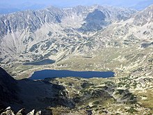
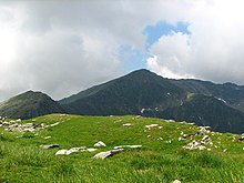
The Southern Carpathian group are the second highest group of mountains in the Carpathian Mountain range (after Tatra), reaching heights of over 2,500m. Although considerably smaller than the Alps, they are classified as having an alpine landscape. Their high mountain character, combined with great accessibility, makes them popular with tourist and scientists.
The highest peaks are:
- Moldoveanu Peak, 2,544 metres - Făgăraş Mountains
- Negoiu, 2,535 metres - Făgăraş Mountains
- Parângu Mare, 2,519 metres - Parâng Mountains
- Peleaga, 2,509 metres - Retezat Mountains
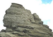
- Omu (mountain) 2,507 metres - Bucegi Mountains
In spite of the heights, some of the most accessible passings in the Carpathians in Romania are along the rivers who cross the mountain range (the Olt River) or who form wide valleys (along the Prahova River Valley or along the Jiu River Valley).
Mountain ranges


From east to west, four mountain groups can be identified, separated by different river valleys.
- Bucegi Mountains group - between the Prahova and Dâmboviţa Rivers.
- Bucegi Mountains (Munţii Bucegi)
- Leaotă Mountains (Munţii Leaotă)
- Făgăraş Mountains group - between the Dâmboviţa River and the Olt River.
- Făgăraş Mountains (Munţii Făgăraşului)
- Iezer Mountains (Munţii Iezer; literally: "Mountains of the Deep Lake")
- Piatra Craiului (literally: "Rock of the King")
- Cozia Mountains (Munţii Cozia)
- Parâng Mountains group - between the Olt River and the Jiu River.
- Parâng Mountains (Munţii Parâng)
- Şureanu Mountains (Munţii Şureanu/M. Sebeşului)
- Cindrel Mountains (Munţii Cindrel/M. Cibinului)
- Lotru Mountains (Munţii Lotrului; literally: "Mountains of the Thief")
- Căpăţână Mountains (Munţii Căpăţânii; literally: "Mountains of the Skull")
- Retezat-Godeanu Mountains group - between the Jiu River and the Timiş and Cerna Rivers.
- Retezat Mountains (Munţii Retezat; literally: "Hewed Mountains")
- Godeanu Mountains (Munţii Godeanu)
- Vâlcan Mountains (Munţii Vâlcan)
- Mehedinţi Mountains (Munţii Mehendinţi)
- Cerna Mountains (Munţii Cernei)
- Ţarcu Mountains (Munţii Ţarcu; literally: "Pen Mountains").
The first two groups are steepest on the North side, and the last two are steepest on the South side.
References
See also
- Divisions of the Carpathians
- Prahova Valley, at the Eastern end
- Iron Gates, at the South-Western end
External links
45°30′N 24°15′E / 45.500°N 24.250°E / 45.500; 24.250
| Divisions, Groups, and Ranges of the Carpathian Mountains | ||||||
|---|---|---|---|---|---|---|
| Western Carpathians |
|  | ||||
| Eastern Carpathians |
| |||||
| Southern Carpathians | ||||||
| Western Romanian Carpathians | ||||||
| Serbian Carpathians | ||||||
| Adjacent regions | ||||||
| Grouping by country | ||||||