| Revision as of 09:56, 5 February 2007 editTimchen (talk | contribs)15 editsNo edit summary← Previous edit | Revision as of 09:57, 5 February 2007 edit undoSengkang (talk | contribs)38,820 edits Revert to revision 105687441 dated 2007-02-05 00:28:24 by CambridgeBayWeather using popupsNext edit → | ||
| Line 1: | Line 1: | ||
| ] lives on one of these,! | |||
| {{otheruses}} | {{otheruses}} | ||
Revision as of 09:57, 5 February 2007
For other uses, see Cloud (disambiguation).
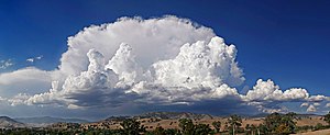
A cloud is a visible mass of condensed droplets or frozen crystals suspended in the atmosphere above the surface of the Earth or another planetary body. The branch of meteorology in which clouds are studied is nephology.
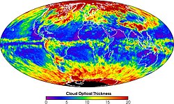
On Earth the condensing substance is water vapor, which forms small droplets or ice crystals, typically 0.01 mm in diameter. When surrounded by billions of other droplets or crystals they become visible as clouds. Dense deep clouds exhibit a high reflectance (70% to 95%) throughout the visible range of wavelengths: they thus appear white, at least from the top. Cloud droplets tend to scatter light efficiently, so that the intensity of the solar radiation decreases with depth into the cloud, hence the grey or even sometimes dark appearance of the clouds at their base. Thin clouds may appear to have acquired the color of their environment or background, and clouds illuminated by non-white light, such as during sunrise or sunset, may be colored accordingly. In the near-infrared range, however, clouds would appear darker because the water that constitutes the cloud droplets strongly absorbs solar radiation at those wavelengths.
Cloud formation and properties

Clouds form when the invisible water vapor in the air condenses into visible water droplets or ice crystals. This can happen in three ways:
1. The air is cooled below its saturation point. This happens when the air comes in contact with a cold surface or a surface that is cooling by radiation, or the air is cooled by adiabatic expansion (rising). This can happen:
- along warm and cold fronts (frontal lift)
- where air flows up the side of a mountain and cools as it rises higher into the atmosphere (orographic lift)
- by the convection caused by the warming of a surface by insolation (diurnal heating)
- when warm air blows over a colder surface such as a cool body of water.
2. Clouds can be formed when two air masses below saturation point mix. Examples are breath on a cold day, aircraft contrails and Arctic sea smoke.
3. The air stays the same temperature but absorbs more water vapor into it until it reaches saturation point.
The water in a typical cloud can have a mass of up to several million tonnes. However, the volume of a cloud is correspondingly high, and the net density of the relatively warm air holding the droplets is low enough that air currents below and within the cloud are capable of keeping it suspended. As well, conditions inside a cloud are not static: water droplets are constantly forming and re-evaporating. A typical cloud droplet has a radius on the order of 1 x 10 m and a terminal velocity of about 1-2 cm/s. This gives these droplets plenty of time to re-evaporate as they fall into the warmer air beneath the cloud.

Most water droplets are formed when water vapor condenses around a condensation nucleus, a tiny particle of smoke, dust, ash, or salt. In supersaturated conditions, water droplets may act as condensation nuclei.
The growth of water droplets around these nuclei in supersaturated conditions is given by the Mason equation.
Water droplets large enough to fall to the ground are produced in two ways. The most important means is through the Bergeron Process, theorized by Tor Bergeron, in which supercooled water droplets and ice crystals in a cloud interact to produce the rapid growth of ice crystals; these crystals precipitate from the cloud and melt as they fall. This process typically takes place in clouds with tops cooler than -15°C. The second most important process is the collision and wake capture process, occurring in clouds with warmer tops, in which the collision of rising and falling water droplets produces larger and larger droplets, which are eventually heavy enough to overcome air currents in the cloud and the updraft beneath it and fall as rain. As a droplet falls through the smaller droplets which surround it, it produces a "wake" which draws some of the smaller droplets into collisions, perpetuating the process. This method of raindrop production is the primary mechanism in low stratiform clouds and small cumulus clouds in trade winds and tropical regions and produces raindrops of several millimeters diameter.

The actual form of cloud created depends on the strength of the uplift and on air stability. In unstable conditions convection dominates, creating vertically developed clouds. Stable air produces horizontally homogeneous clouds. Frontal uplift creates various cloud forms depending on the composition of the front (ana-type or kata-type warm or cold front). Orographic uplift also creates variable cloud forms depending on air stability, although cap cloud and wave clouds are specific to orographic clouds.
"Hot Ice" and "Ice Memory" in cloud formation
In addition to being the colloquial term sometimes used to describe dry ice, hot ice is the name given to a surprising phenomenon in which water can be turned into ice at room temperature by supplying an electric field of the order of 1 million volts per meter. (Choi 2005). The effect of such electric fields has been suggested as an explanation of cloud formation. This theory, however, is highly controversial and is not, by any means, widely accepted as being the actual mechanism of cloud formation. The first time cloud ice forms around a clay particle, it requires a temperature of -10°C, but subsequent freezing around the same clay particle requires a temperature of just -5°C, suggesting some kind of "ice memory" (Connolly, P.J, et al, 2005).
Cloud classification
Main article: List of cloud types
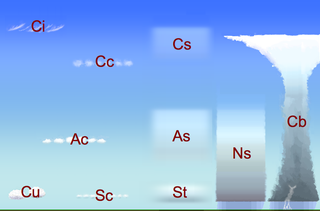
Clouds are divided into two general categories: layered and convective. These are named stratus clouds (or stratiform, the Latin stratus means layer) and cumulus clouds (or cumuliform; cumulus means piled up). These two cloud types are divided into four more groups that distinguish the cloud's altitude. Clouds are classified by the cloud base height not the cloud top. This system was proposed by Luke Howard in 1802 in a presentation to the Askesian Society.
High clouds (Family A)
These generally form above 16,500 feet (5,000 m), in the cold region of the troposphere. However, in Polar regions, they may form as low as 10,000 ft (3,048 m). They are denoted by the prefix cirro- or cirrus. At this altitude, water almost always freezes so clouds are composed of ice crystals. The clouds tend to be wispy, and are often transparent.
Clouds in Family A include:
- Cirrus (Ci)
- Cirrus uncinus
- Cirrus Kelvin-Helmholtz Colombia
- Cirrostratus (Cs)
- Cirrocumulus (Cc)
- Pileus
- Contrail, a long thin cloud which develops as the result of the passage of an aircraft at high altitudes.
Middle clouds (Family B)

These develop between 6,500 and 16,500 feet (between 2,000 and 5,000 m) and are denoted by the prefix alto-. They are made of water droplets and are frequently supercooled.
Clouds in Family B include:
- Altostratus (As)
- Altostratus undulatus
- Altocumulus (Ac)
- Altocumulus undulatus
- Altocumulus mackerel sky
- Altocumulus castellanus
- Altocumulus lenticularis
Low clouds (Family C)

These are found up to 6,500 feet (2,000 m) and include the stratus (dense and grey). When stratus clouds contact the ground, they are called fog.
Clouds in Family C include:
- Stratus (St)
- Nimbostratus (Ns)
- Cumulus humilis (Cu)
- Cumulus mediocris (Cu)
- Stratocumulus (Sc)
Vertical clouds (Family D)

These clouds can have strong up-currents, rise far above their bases and form at many heights.
Clouds in Family D include:
- Cumulonimbus (associated with heavy precipitation and thunderstorms) (Cb)
- Cumulonimbus incus
- Cumulonimbus calvus
- Cumulonimbus with mammatus
- Cumulus congestus
- Pyrocumulus

Other clouds
A few clouds can be found above the troposphere; these include noctilucent and polar stratospheric clouds (or nacreous clouds), which occur in the mesosphere and stratosphere respectively.
Cloud fields
A cloud field is simply a group of clouds, but sometimes cloud fields can take on certain shapes that have their own characteristics and are specially classified. For example, stratocumulus clouds can often be found in the following forms:
- Open cell, which resembles a honeycomb, with clouds around the edges and clear, open space in the middle.
- Closed cell, which is cloudy in the center and clear on the edges, similar to a filled honeycomb.
- Actinoform, which resembles a leaf or a spoked wheel.
Colors


The color of a cloud tells much about what is going on inside the cloud.
Clouds form when relatively warm air containing water vapor is lighter than its surrounding air and this causes it to rise. As it rises it cools and the vapor condenses out of the air as micro-droplets. These tiny particles of water are relatively densely packed, and sunlight cannot penetrate far into the cloud before it is reflected out, giving a cloud its characteristic white color. As a cloud matures, the droplets may combine to produce larger droplets, which may themselves combine to form droplets large enough to fall as rain. In this process of accumulation, the space between droplets becomes larger and larger, permitting light to penetrate much farther into the cloud. If the cloud is sufficiently large, and the droplets within are spaced far enough apart, it may be that a percentage of the light which enters the cloud is not reflected back out before it is absorbed (Think of how much farther one can see in a heavy rain as opposed to how far one can see in a heavy fog). This process of reflection/absorption is what leads to the range of cloud color from white through grey through black. For the same reason, the undersides of large clouds and heavy overcasts appear various degrees of grey; little light is being reflected or transmitted back to the observer.
Other colors occur naturally in clouds. Bluish-grey is the result of light scattering within the cloud. In the visible spectrum, blue and green are at the short end of light's visible wavelengths, while red and yellow are at the long end. The short rays are more easily scattered by water droplets, and the long rays are more likely to be absorbed. The bluish color is evidence that such scattering is being produced by rain-sized droplets in the cloud.
A more ominous color is the one seen frequently by severe weather observers. A greenish tinge to a cloud is produced when sunlight is scattered by ice. A cumulonimbus cloud which shows green is a pretty sure sign of imminent heavy rain, hail, strong winds and possible tornados.
Yellowish clouds are rare, but may occur in the late spring through early fall months during forest fire season. The yellow color is due to the presence of smoke.
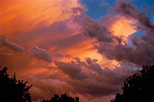
Red, orange and pink clouds occur almost entirely at sunrise/sunset and are the result of the scattering of sunlight by the atmosphere itself. The clouds themselves are not that color; they are merely reflecting the long (and unscattered) rays of sunlight which are predominant at those hours. The effect is much the same as if one were to shine a red spotlight on a white sheet. In combination with large, mature thunderheads, this can produce blood-red clouds. The evening before the Edmonton, Alberta tornado in 1987, Edmontonians observed such clouds — deep black on their dark side and intense red on their sunward side. In this case, the adage "red sky at night, sailor's delight" was clearly incorrect.
Global dimming
The recently recognized phenomenon of global dimming is thought to be caused by changes to the reflectivity of clouds due to the increased presence of aerosols and other particulates in the atmosphere.
Global brightening
New research From Dimming to Brightening: Decadal Changes in Solar Radiation at Earth's Surface by Martin Wild et al. (Science 6 May 2005; 308: 847-850) indicates global brightening trend.
Clouds on other planets
Within our solar system, any planet with an atmosphere also has clouds. Venus' clouds are composed entirely of sulfuric acid droplets. Mars has high, thin clouds of water ice. Both Jupiter and Saturn have an outer cloud deck composed of ammonia clouds, an intermediate deck of ammonium hydrosulfide clouds and an inner deck of water clouds. Uranus and Neptune have atmospheres dominated by methane clouds.
Saturn's moon Titan has clouds which are believed to be composed of droplets of liquid methane. The Cassini-Huygens Saturn mission has uncovered evidence of a fluid cycle on Titan, including fluvial channels on the surface of the moon.
See also

- Cloud albedo
- Cloud Appreciation Society
- Cloud base
- Cloud feedback
- Cloud forcing
- Cloud seeding
- Cloud types
- Cloudscape photography
- Coalescence
- Extraterrestrial skies
- Flight ceiling
- Fog
- Fractus cloud
- Mammatus
- Mist
- Monsoon
- Mushroom cloud
- Orographic lift
- Precipitation
- Thunderstorm
- Tornado
- Tropical cyclone
- Weather lore
Reference
- Hamblyn, Richard The Invention of Clouds — How an Amateur Meteorologist Forged the Language of the Skies Picador; Reprint edition (August 3, 2002). ISBN 0312420013
External links
- Cloud atlas with many cloud fotos and descriptions
- Australia Severe Weather: cloud classification system Lots of photos; click on the thumbnails to get bigger images.
- Chitambo Clouds – Clouds and other meteorological phenomena Photographs and info. on different types of clouds
- BadMeteorology's explanation of why clouds form
- Cloud Appreciation Society Aesthetics of clouds
- United States National Weather Service
- The Weather Channel, United States
- Cloud photography
- Cloud Naming Lesson
- Cloud and Weather Photography
| Cloud genera and selected species, supplementary features, and other airborne hydrometeors - WMO Latin terminology except where indicated | |||||||||||||||||||||||||||||||||||||||||||||||||||||||||||||||||||||
|---|---|---|---|---|---|---|---|---|---|---|---|---|---|---|---|---|---|---|---|---|---|---|---|---|---|---|---|---|---|---|---|---|---|---|---|---|---|---|---|---|---|---|---|---|---|---|---|---|---|---|---|---|---|---|---|---|---|---|---|---|---|---|---|---|---|---|---|---|---|
| Mesospheric |
| ||||||||||||||||||||||||||||||||||||||||||||||||||||||||||||||||||||
| Stratospheric |
| ||||||||||||||||||||||||||||||||||||||||||||||||||||||||||||||||||||
| Tropospheric |
| ||||||||||||||||||||||||||||||||||||||||||||||||||||||||||||||||||||