| Revision as of 23:01, 16 October 2022 editDragonofBatley (talk | contribs)Extended confirmed users20,538 editsNo edit summaryTag: Visual edit: Switched← Previous edit | Revision as of 23:04, 16 October 2022 edit undoDragonofBatley (talk | contribs)Extended confirmed users20,538 edits Added photoTag: Visual edit: SwitchedNext edit → | ||
| Line 34: | Line 34: | ||
| | imagesize = 240px | | imagesize = 240px | ||
| | image_alt = | | image_alt = | ||
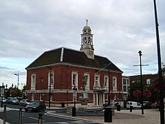
| | image_caption = ]. the administrative centre of the district | | image_caption = ]. the administrative centre of the district and one of the three towns | ||
| | image_shield = | | image_shield = | ||
| | shield_size = | | shield_size = | ||
| Line 61: | Line 61: | ||
| | website = {{URL|https://www.braintree.gov.uk/}} | | website = {{URL|https://www.braintree.gov.uk/}} | ||
| }} | }} | ||
| ] | |||
| '''Braintree''' is a ] in the ] ] of ], with a population (2011 census) of 147,084. Its main town is ]. | |||
| ⚫ | '''Braintree''' is a ] in the ] ] of ], with a population (2011 census) of 147,084. Its main town is ]. The three towns of the district are Braintree, ] and ]. The district was formed on 1 April 1974 by the merger of the ]s of ], ], and ] and (for list of parishes) ] and ]. | ||
| ] | |||
| The main centres of population are Braintree, ] and ]. | |||
| ⚫ | The district was formed on 1 April 1974 by the merger of the ]s of ], ], and ] and (for list of parishes) ] and ]. | ||
| ==Council== | ==Council== | ||
| The council is controlled by the ] who hold 34 of the 49 seats. | The council is controlled by the ] who hold 34 of the 49 seats. | ||
Revision as of 23:04, 16 October 2022
Non-metropolitan district in England
| Braintree District | |
|---|---|
| Non-metropolitan district | |
 Braintree. the administrative centre of the district and one of the three towns Braintree. the administrative centre of the district and one of the three towns | |
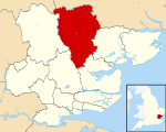
 Braintree shown within Essex Braintree shown within Essex | |
| Sovereign state | United Kingdom |
| Country | England |
| Region | East of England |
| Non-metropolitan county | Essex |
| Status | Non-metropolitan district |
| Admin HQ | Braintree |
| Incorporated | 1 April 1974 |
| Government | |
| • Type | Non-metropolitan district council |
| • Body | Braintree District Council |
| • Leadership | Leader & Cabinet (Conservative) |
| • MPs | James Cleverly Priti Patel |
| Area | |
| • Total | 236.18 sq mi (611.71 km) |
| • Rank | 58th (of 296) |
| Population | |
| • Total | 157,681 |
| • Rank | 131st (of 296) |
| • Density | 670/sq mi (260/km) |
| • Ethnicity | 95.% White 1.1% Mixed 1.3% S.Asian 1.0% Black |
| Time zone | UTC0 (GMT) |
| • Summer (DST) | UTC+1 (BST) |
| ONS code | 22UC (ONS) E07000067 (GSS) |
| OS grid reference | TL7522 |
| Website | www |

Braintree is a local government district in the English county of Essex, with a population (2011 census) of 147,084. Its main town is Braintree. The three towns of the district are Braintree, Halstead and Witham. The district was formed on 1 April 1974 by the merger of the urban districts of Braintree and Bocking, Halstead, and Witham and (for list of parishes) Braintree Rural District and Halstead Rural District.

Council
The council is controlled by the Conservatives who hold 34 of the 49 seats.
Further information: Braintree District Council electionsWards
There are 26 wards:
- Bocking Blackwater
- Bocking North
- Bocking South
- Braintree Central and Beckers Green
- Braintree South
- Braintree West
- Bumpstead
- Coggeshall
- Gosfield & Greenstead Green
- Great Notley & Black Notley
- Halstead St Andrews
- Halstead Trinity
- Hatfield Peverel and Terling
- Hedingham
- Kelvedon and Feering
- Rayne
- Silver End and Cressing
- Stour Valley North (includes Ashen and Foxearth)
- Stour Valley South (includes Bulmer and Alphamstone)
- The Colnes
- Three Fields
- Witham Central
- Witham North
- Witham South
- Witham West
- Yeldham
Arms
|
References
- "Braintree District Council".
- "East of England Region". Civic Heraldry of England. Retrieved 8 March 2021.
External links
- Enjoy Braintree District; places to stay, arts, museum, culture events listing by the Braintree Council
- Braintree District Council
- Enjoy Braintree District
| Unitary authorities | |
|---|---|
| Boroughs or districts | |
| Major settlements (cities in italics) |
|
| Rivers | |
| Districts of the East of England | ||
|---|---|---|
| Bedfordshire |  | |
| Cambridgeshire | ||
| Essex | ||
| Hertfordshire | ||
| Norfolk | ||
| Suffolk | ||
51°52′55″N 0°33′09″E / 51.8819°N 0.5525°E / 51.8819; 0.5525
This Essex location article is a stub. You can help Misplaced Pages by expanding it. |