| Revision as of 05:58, 7 June 2023 editCahnc (talk | contribs)85 edits the Spanish word for "town" is not relevant hereTag: Reverted← Previous edit | Revision as of 06:00, 7 June 2023 edit undoCahnc (talk | contribs)85 edits WP:NOTTRAVELTag: RevertedNext edit → | ||
| Line 77: | Line 77: | ||
| }} | }} | ||
| '''Hornopirén''' is a town in the commune of ] in ], ]. It lies along the northern portion of ]. It had 3,629 inhabitants as of 2017.<ref name="INE2017">{{cite web |url=https://geoarchivos.ine.cl/File/pub/Cd_Pb_Al_Cs_2019.pdf |title=Ciudades, pueblos, aldeas y caceríos 2019 |publisher= National Statistics Institute|date=2019 |access-date=November 1, 2020|language=es}}</ref> | '''Hornopirén''' is a town in the commune of ] in ], ]. It lies along the northern portion of ]. It had 3,629 inhabitants as of 2017.<ref name="INE2017">{{cite web |url=https://geoarchivos.ine.cl/File/pub/Cd_Pb_Al_Cs_2019.pdf |title=Ciudades, pueblos, aldeas y caceríos 2019 |publisher= National Statistics Institute|date=2019 |access-date=November 1, 2020|language=es}}</ref> | ||
| Hornopirén is an important tourist stop on Chile’s Carretera Austral (Highway 7) and serves as the departure point for the bi-modal car ferry system on the Carretera Austral through the Palena Province. | Hornopirén is an important tourist stop on Chile’s Carretera Austral (Highway 7) and serves as the departure point for the bi-modal car ferry system on the Carretera Austral through the Palena Province. It also provides access to Hornopirén National Park and the Northern Patagonia Fjordlands. Boat trips run from the town to remote hot springs and campgrounds in the fjordlands. | ||
| From Hornopirén, a 3:15 long ferry crosses the Comau Fjord in Pumalin Douglass Tompkins National Park. Upon arrival at the embarcadero at Leptepu, a short 10-minute drive takes travelers to the shorter 40-minute crossing at Renihue Fjord to Caleta Gonzalo. | |||
| In addition to its strategic position as departure point for the bi-modal car ferry, Hornopirén has modest tourist infrastructure as the gateway to Hornopirén National Park and the Northern Patagonia Fjordlands. Boats can be hired to take tourists to remote hot springs and campgrounds in the fjordlands. | |||
| ==References== | ==References== | ||
Revision as of 06:00, 7 June 2023
Place in Palena, Los Lagos| Hornopirén | |
|---|---|
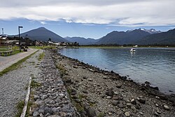
 Seaside road of Hornopirén and Hornopirén Volcano in the background. Seaside road of Hornopirén and Hornopirén Volcano in the background. | |
| Coordinates: 41°57′58.32″S 72°28′14.16″W / 41.9662000°S 72.4706000°W / -41.9662000; -72.4706000 | |
| Region | Los Lagos |
| Province | Palena |
| Municipalidad | Hualaihué |
| Comuna | Hualaihué |
| Government | |
| • Type | Municipalidad |
| • Alcalde | Freddy Ibacache Muñoz |
| Elevation | 15 m (49 ft) |
| Population | |
| • Total | 3,629 |
| Time zone | UTC−04:00 (Chilean Standard) |
| • Summer (DST) | UTC−03:00 (Chilean Daylight) |
| Area code | Country + town = 56 + 65 |
Hornopirén is a town in the commune of Hualaihué in Palena Province, southern Chile. It lies along the northern portion of Carretera Austral. It had 3,629 inhabitants as of 2017. Hornopirén is an important tourist stop on Chile’s Carretera Austral (Highway 7) and serves as the departure point for the bi-modal car ferry system on the Carretera Austral through the Palena Province. It also provides access to Hornopirén National Park and the Northern Patagonia Fjordlands. Boat trips run from the town to remote hot springs and campgrounds in the fjordlands.
References
- "Ciudades, pueblos, aldeas y caceríos 2019" (PDF) (in Spanish). National Statistics Institute. 2019. Retrieved November 1, 2020.
This Los Lagos Region location article is a stub. You can help Misplaced Pages by expanding it. |