| Revision as of 12:53, 4 August 2009 edit91.84.66.22 (talk)No edit summary← Previous edit | Revision as of 12:55, 4 August 2009 edit undoPolynomial123 (talk | contribs)785 edits Reverted edits by 91.84.66.22 (talk) to last version by CircleOfWillisNext edit → | ||
| Line 7: | Line 7: | ||
| Chilworth is home to the ] Science Park (formerly the Chilworth Science Park') which houses the main satellite uplink earth station of ] (BSkyB). This facility uplinks signals (both Sky and some third party) to the ] satellites at ] and ]'s ] at 28.5°E. | Chilworth is home to the ] Science Park (formerly the Chilworth Science Park') which houses the main satellite uplink earth station of ] (BSkyB). This facility uplinks signals (both Sky and some third party) to the ] satellites at ] and ]'s ] at 28.5°E. | ||
| There is a small public house on the main road through the village called ''The Chilworth Arms'' (formally ''The Clump''). . Chilworth has a village hall and football field near the pub and there is a kennels and cattery in Chilworth Common, one of the local wooded areas. There is a small convenience store; the Post Office is now closed. Notable Chilworth residents have included circus impressario ] and Southampton football star ]. | There is a small public house on the main road through the village called ''The Chilworth Arms'' (formally ''The Clump''). There is also a public telephone box on the same road opposite the pub. The telephone box is next to the memorial of the dead who came from Chilworth and fought in the world wars. Chilworth has a village hall and football field near the pub and there is a kennels and cattery in Chilworth Common, one of the local wooded areas. There is a small convenience store; the Post Office is now closed. Notable Chilworth residents have included circus impressario ] and Southampton football star ]. | ||
| {{Districts of Southampton}} | {{Districts of Southampton}} | ||
Revision as of 12:55, 4 August 2009
This article is about Chilworth in Hampshire. For Chilworth in Surrey, see Chilworth, Surrey.

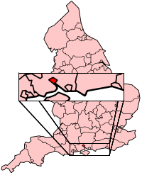
Chilworth is a village in Hampshire, UK, very close to the city of Southampton. Good travel connections and restricted development have led to the village becoming particularly affluent. Chilworth Old Village, at the west end, consists of former farm workers' thatched cottages interlaced with modern houses and bungalows built in the 1950s. The Anglican Church of St Denys lies on the edge of the Old Village.
Chilworth is home to the University of Southampton Science Park (formerly the Chilworth Science Park') which houses the main satellite uplink earth station of British Sky Broadcasting (BSkyB). This facility uplinks signals (both Sky and some third party) to the Astra satellites at 28.2° east and Eutelsat's Eurobird 1 at 28.5°E.
There is a small public house on the main road through the village called The Chilworth Arms (formally The Clump). There is also a public telephone box on the same road opposite the pub. The telephone box is next to the memorial of the dead who came from Chilworth and fought in the world wars. Chilworth has a village hall and football field near the pub and there is a kennels and cattery in Chilworth Common, one of the local wooded areas. There is a small convenience store; the Post Office is now closed. Notable Chilworth residents have included circus impressario Jimmy Chipperfield and Southampton football star Matthew Le Tissier.
External links
- Southampton Science Park
- St Denys' Chilworth
- Map of the Manor of Chilworth in the County of Southampton belonging to Peter Serle Esq., 1755
50°58′N 1°25′W / 50.967°N 1.417°W / 50.967; -1.417
This Hampshire location article is a stub. You can help Misplaced Pages by expanding it. |
