| Revision as of 14:00, 28 October 2010 view sourceNableezy (talk | contribs)Extended confirmed users, Page movers, Pending changes reviewers, Rollbackers56,197 edits Undid revision 393406186 by Brewcrewer (talk) and the lead should include it as well← Previous edit | Revision as of 16:41, 28 October 2010 view source WookieInHeat (talk | contribs)Extended confirmed users, Pending changes reviewers, Rollbackers7,448 edits Reverted to revision 393406186 by Brewcrewer; rv. removing redundant info from lede, see article talk page. (TW)Next edit → | ||
| Line 19: | Line 19: | ||
| '''Psagot''' ({{lang-he-n|פְּסָגוֹת}}, ''lit.'' Peaks) is a ] ] in the ]. Located on the Jabel Tawil/Mount Tawil hill near ], it falls under the jurisdiction of ]. The offices of the regional council are located in Psagot.<ref name="hareuveni" /> In 2008 it had a population of 1,623.<ref name="cbs-loc" /> | '''Psagot''' ({{lang-he-n|פְּסָגוֹת}}, ''lit.'' Peaks) is a ] ] in the ]. Located on the Jabel Tawil/Mount Tawil hill near ], it falls under the jurisdiction of ]. The offices of the regional council are located in Psagot.<ref name="hareuveni" /> In 2008 it had a population of 1,623.<ref name="cbs-loc" /> | ||
| Israeli settlements in the West Bank are considered ], but the Israeli government disputes this.<ref name="BBC_The_Geneva_Convention">{{cite web | |||
| | url = http://news.bbc.co.uk/2/hi/middle_east/1682640.stm | |||
| | title = The Geneva Convention | |||
| | publisher = ] | |||
| }}</ref> | |||
| ==Geography== | ==Geography== | ||
Revision as of 16:41, 28 October 2010
| The neutrality of this article's introduction is disputed. Relevant discussion may be found on the talk page. Please do not remove this message until conditions to do so are met. (September 2010) (Learn how and when to remove this message) |
| Psagot | |
|---|---|
 | |
| Country | Israel |
| Council | Mateh Binyamin |
| Region | West Bank |
| Affiliation | Amana |
| Founded | 1981 |
| Founded by | Beit VeGan residents |
| Population | 1,623 |
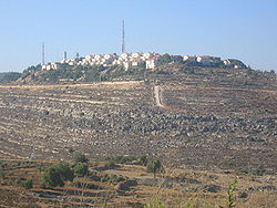
Psagot (Template:Lang-he-n, lit. Peaks) is a communal Israeli settlement in the West Bank. Located on the Jabel Tawil/Mount Tawil hill near Ramallah, it falls under the jurisdiction of Mateh Binyamin Regional Council. The offices of the regional council are located in Psagot. In 2008 it had a population of 1,623.
Geography
Psagot is located on the peak of Mount Tawil, hence its name. It can be accessed from Highway 60 from the north and south.
History
Prior to 1967, Jabel Tawil hill was a green space used by local residents and distant visitors as a recreational site. Due to frequent visitors from the Persian Gulf, it was known to locals as the Kuwaiti hill. In 1964, part of the site was purchased by the municipality of Al Quds (Jerusalem) to build a tourist resort. Following the 1967 War, it came under Israeli military control. In September 1976, "Arabs were prohibited from building" in the area.
Psagot was established in 1981 by a gar'in of residents of the Jerusalem neighborhood of Beit VeGan with the support of the Likud party. Psagot is considered illegal under international law, though Israel disputes this.
Economy
The Psagot winery was founded by Na’ama and Yaakov Berg, who planted vineyards in 1998. In addition to a modern barrel cellar, some of the oak barriques are stored in a cave dating back to the Second Temple. The winery’s top wine is a Bordeaux blend named Edom. Regular varietal wines are produced in the Psagot series and there is also a Port-style wine. In 2007 and 2008, the winery produced 65,000 bottles annually. Other wineries exist around Psagot, and the Yesha Council hopes to make them a tourist attraction. According to the local Palestinians and the Israeli human rights group Yesh Din, the wineries are partially planted on a privately owned Palestinian land.
References
- ^ HaReuveni, Immanuel (1999). Lexicon of the Land of Israel. Miskal – Yedioth Ahronoth Books. p. 795. ISBN 965-448-413-7.
- "Locality File" (XLS). Israel Central Bureau of Statistics. 2008. Retrieved 22 June 2010.
- ^ Hilal, Sandi (Spring 2009). "The Future Archaeology of Israel's Colonisation". Afterall Journal (20).
{{cite journal}}: Unknown parameter|coauthors=ignored (|author=suggested) (help) - Arab Women's Information Committee (1 January 1977). The Arabs Under Israeli Occupation, 1980. Inst for Palestine Studies. p. 67.
{{cite book}}: Unknown parameter|coauthors=ignored (|author=suggested) (help) - ^ Settler vineyards take root in West Bank BBC. 17 June 2009
- Whitacker, Brian. The summit of Middle East tension The Guardian. 3 September 2001
- Psagot Winery at Rogov's Reviews
Categories: