| Revision as of 02:51, 24 January 2011 editSerouj (talk | contribs)Pending changes reviewers6,573 edits pic+; text fixes← Previous edit | Revision as of 19:51, 24 January 2011 edit undoXebulon (talk | contribs)195 edits not necessary. the province had a number of historical names. explore all the names in a separate section if you wantNext edit → | ||
| Line 58: | Line 58: | ||
| {{Armenia}} | {{Armenia}} | ||
| {{FixBunching|bot}} | {{FixBunching|bot}} | ||
| '''Vayots Dzor''' (]: {{lang|hy|]}} |
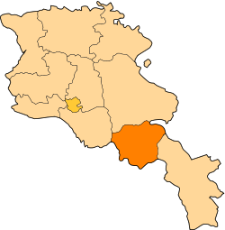
'''Vayots Dzor''' (]: {{lang|hy|]}}) is a ] ('']'') of ]. It lies in the south-east of the country, bordering the ] exclave of ] in the west and the ] in the east. It covers an area of 2,308 km². With a population of only 53,230 (2002 census), it is the most sparsely populated province in the country. The capital is ]. | ||
| ==History== | ==History== | ||
Revision as of 19:51, 24 January 2011
Province in Armenia| Vayots Dzor Վայոց Ձոր | |
|---|---|
| Province | |
 | |
| Country | Armenia |
| Capital | Yeghegnadzor |
| Government | |
| • Governor | Sergey Bagratyan |
| Area | |
| • Total | 2,308 km (891 sq mi) |
| • Rank | 7 |
| Population | |
| • Total | 53,230 |
| • Rank | 11 |
| • Density | 23/km (60/sq mi) |
| Time zone | UTC+04 |
| • Summer (DST) | UTC+05 |
| Postal code | 3601-3810 |
| ISO 3166 code | AM-VD |
| FIPS 10-4 | AM10 |
| Website | vdzor.region.am |
Template:FixBunching Template:Armenia Template:FixBunching Vayots Dzor (Armenian: Վայոց Ձոր) is a province (marz) of Armenia. It lies in the south-east of the country, bordering the Nakhichevan exclave of Azerbaijan in the west and the Nagorno-Karabakh Republic in the east. It covers an area of 2,308 km². With a population of only 53,230 (2002 census), it is the most sparsely populated province in the country. The capital is Yeghegnadzor.
History
During the Middle Ages, Vayots Dzor was a principality of the Kingdom of Syunik. The name literally means "Valley of Woes" because the area was devastated by several earthquakes during its history.
Sights
The province is rich in historical and architectural sites, such as the Noravank monastery, the Smbataberd fortress, and the Tsakhats Kar monastery. The spa town of Jermuk, one of Armenia's premiere tourist attractions during Soviet times, is also located in the province.
Geography
Vayots Dzor borders the following marzer:
- Ararat - northwest
- Gegharkunik - north
- Syunik - southeast
Communities
The province of Vayots Dzor consists of the following 44 communities (hamaynkner), of which 3 (bold in the table) are considered urban and 41 are considered rural. The division below is by raion, the administrative subdivisions of Armenia before 1995. She was part of Sharur-Daralagez uzeyd in Erivan Governorate as Daralagez before foundation of Democratic Republic of Armenia in 1918.
| Vayk | Jermuk | Yeghegnadzor |
|---|---|---|
Gallery
- Vayots Dzor
-
Noravank, 1205 AD
-
 Areni Church, 1321 AD
- Shaki waterfall Shaki waterfall
-
Jermuk
-
 Sparkling water of Jermuk
-
 The Areni-1 cave complex
References
- "RA Vayots Dzor Marz" (PDF). Marzes of the Republic of Armenia in Figures, 2002-2006. National Statistical Service of the Republic of Armenia. 2007.
{{cite web}}: Cite has empty unknown parameter:|1=(help)
External links
| Provinces of Armenia | ||
|---|---|---|
| Provinces (մարզեր) | ||
| City with special status |
| |
This article about a location in Vayots Dzor Province, Armenia is a stub. You can help Misplaced Pages by expanding it. |