| Revision as of 02:37, 11 March 2019 editSantasa99 (talk | contribs)Extended confirmed users26,114 edits →top← Previous edit | Revision as of 02:46, 11 March 2019 edit undoSantasa99 (talk | contribs)Extended confirmed users26,114 edits →MapsNext edit → | ||
| Line 20: | Line 20: | ||
| == Maps == | == Maps == | ||
| <gallery> | |||
| {| class="wikitable" align=center valign=top cellspacing=2 | |||
| ⚫ | Upravni zemljevid Ilirskih provinc leta 1813.jpg|"Turkish Croatia" (''Türkisch Croatien'') on a Austro-Hungarian military map from 1813. | ||
| |- bgcolor=#EACB96 align=center valign=top | |||
| ⚫ | 1827 Finley Map of Turkey in Europe, Greece and the Balkans - Geographicus - TurkeyEurope-finley-1827.jpg|An 1827 map of the Ottoman conquest in Europe - A. Finley ("Turkish Croatia" in yellow). | ||
| ||]<span style="font-size: 75%">Map of Croatia during the reign<br />of King ]<br />(11th century): Turkish Croatia<br />was in the center of the<br />Kingdom</span> | |||
| </gallery> | |||
| ⚫ | |||
| ⚫ | |||
| |} | |||
| ==See also== | ==See also== | ||
Revision as of 02:46, 11 March 2019
This article has multiple issues. Please help improve it or discuss these issues on the talk page. (Learn how and when to remove these messages)
|
| This article may document a neologism or protologism in such a manner as to promote it. Please add more reliable sources to establish its current use and the impact the term has had on its field. Otherwise consider renaming or deleting the article. (March 2019) (Learn how and when to remove this message) |

Turkish Croatia (Template:Lang-hr), was a geographical term and period neologism, which can be vied as hapax legomenon, invented by Austro-Hungarian military geographers sometime during 17th to 19th century Ottoman–Habsburg wars, for the part of the contested territory in present day Bosnia and Herzegovina, specifically region of Bosanska Krajina (Krajina = Template:Lang-en; during Medieval Bosnia known as Donji Kraji (Template:Lang-en) and Zapadne Strane (Template:Lang-en)).
The territory of so-called "Turkish Croatia" was depicted as roughly comprising the land area between the rivers Vrbas in the east, Sava in the northeast, Una in the northwest, as well as Dinara mountain in the south, including the Cazinska krajina pocket in the far west. Parts of Lika, Banovina and northern Dalmatia were also parts of Turkish Croatia, when its borders went further west.
The term started appearing in recent times, since 1990's, only in Croatian far-right nationalist political discourse, without any impact at all on mainstream politics or academic research.
History
In Austro-Hungarian military maps from the 16th to 19th century the so-called "Turkish Croatia" appeared as a borderland to Military Frontier, a Habsburg-controlled part of present-day Croatia, which was administered directly from Vienna's military headquarters. In the 19th century, following the Ottoman–Habsburg wars, and transfer of the Bosnia Vilayet to |Austrian rule at Berlin Congress in 1878, the term "Turkish Croatia" became redundant, as it no longer served its purpose, and disappeared from official usage. The entire territory of Bosnia and Herzegovina came under a direct rule of the Viennese government, and since 1908 annexation became a new Crown land.
It started appearing in unconventional, colloquial usage among some Austria-Hungarian military and political map-makers, in correlation to Ottoman retreat and Austria-Hungarian expansion. From here it found its way into narrative of peculiar Croatian far-right national movement based on a constructs similar to one in Serbia, of so-called "Croatian lands" and "Croatian state rights", promulgated by (Hrvatsko državno pravo), and was typically exploited for purpose of territorial expansion of both Austria-Hungary and later Croatia, via transposition of these "rights" on Bosnia and Herzegovina territory.
Although rarely, it was used for romanticized historiography, as well as in the phantasmagoric politics of "National awakening" and "National integration" of late 19th to early 20th century Croatia. In first half of 20th century with a rise of nationalist fervor, up to the time and establishment of fascist NDH in 1940's, this term appeared again sporadically, with romantic sloganeering of Nedeljko Mihanović, in journalistic and political elaboration in regard to Bosnia and Herzegovina by Frano Milobar, in geopolitical contemplation by Ivo Pilar and Filip Lukas, and politically operationalized by Ante Starčević, and in 1940's Frank and Ante Pavelić.
In more recent times, with a rise of Franjo Tuđman and establishment of Republic of Croatia in 1990's, the term was revived only as part of Croatian far-right nationalist political discourse, with little if any impact on mainstream politics or academic research. However, the term never took hold outside the scope of political extremism and academic fringes.
Maps
-
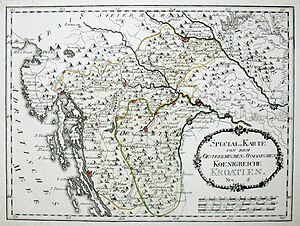
 "Turkish Croatia" (Türkisch Croatien) on a Austro-Hungarian military map from 1813.
-
 An 1827 map of the Ottoman conquest in Europe - A. Finley ("Turkish Croatia" in yellow).
See also
- Ottoman period in the history of Croatia
- Donji Kraji
- Ottoman conquest of Bosnia and Herzegovina
- Bosnia Eyalet
- Demographic history of Bosnia and Herzegovina
External links
- Fortresses in Turkish Croatia /page 56/ (in German)
- Geology books on Turkish Croatia from the 19th century (in Croatian)
- Cover of the August Kaznačić book „Bosnia, Herzegovina and Turkish Croatia“ from 1862 (in Italian)