| Revision as of 14:49, 16 June 2020 editMarkussep (talk | contribs)Autopatrolled, Extended confirmed users, Page movers, Pending changes reviewers, Template editors558,504 editsm Markussep moved page Zeya River to Zeya (river): "River" is not part of the name, see WP:NCRIVER and WT:RIVERS#Article titles for rivers in Russia, Ukraine and Belarus← Previous edit | Revision as of 15:24, 16 June 2020 edit undoMarkussep (talk | contribs)Autopatrolled, Extended confirmed users, Page movers, Pending changes reviewers, Template editors558,504 edits progression, referenceNext edit → | ||
| Line 1: | Line 1: | ||
| {{Infobox river | {{Infobox river | ||
| | name = Zeya |
| name = Zeya | ||
| | name_native = Зея | | name_native = Зея | ||
| | name_native_lang = | | name_native_lang = | ||
| Line 8: | Line 8: | ||
| | image = Zeya River and Island.jpg | | image = Zeya River and Island.jpg | ||
| | image_size = 250px | | image_size = 250px | ||
| | image_caption = Island on |
| image_caption = Island on the Zeya. | ||
| | map = Zeyarivermap.png | | map = Zeyarivermap.png | ||
| | map_size = 250px | | map_size = 250px | ||
| | map_caption = Map of the Amur |
| map_caption = Map of the Amur drainage basin with the Zeya highlighted | ||
| | pushpin_map = | | pushpin_map = | ||
| | pushpin_map_size = 250px | | pushpin_map_size = 250px | ||
| Line 18: | Line 18: | ||
| | subdivision_type1 = Country | | subdivision_type1 = Country | ||
| | subdivision_name1 = ] | | subdivision_name1 = ] | ||
| | subdivision_type2 = | | subdivision_type2 = Federal subject | ||
| | subdivision_name2 = | | subdivision_name2 = ] | ||
| | subdivision_type3 = | | subdivision_type3 = | ||
| | subdivision_name3 = | | subdivision_name3 = | ||
| Line 39: | Line 39: | ||
| | discharge1_max = {{convert|14200|m3/s|cuft/s|abbr=on}} | | discharge1_max = {{convert|14200|m3/s|cuft/s|abbr=on}} | ||
| <!---------------------- BASIN FEATURES --> | <!---------------------- BASIN FEATURES --> | ||
| | source1 = | | source1 = ] | ||
| | source1_location = |
| source1_location = | ||
| | source1_coordinates= | | source1_coordinates= | ||
| | source1_elevation = | | source1_elevation = | ||
| | mouth = | | mouth = ] | ||
| | mouth_location = |
| mouth_location = | ||
| | mouth_coordinates = | | mouth_coordinates = {{coord|50.2419|N|127.598|E|source:kolossus-ruwiki|display=it}} | ||
| | mouth_elevation = | | mouth_elevation = | ||
| | progression = | | progression = {{RAmur}} | ||
| | river_system = | | river_system = | ||
| | basin_size = {{convert|233000|km2|abbr=on}} | | basin_size = {{convert|233000|km2|abbr=on}} | ||
| Line 56: | Line 56: | ||
| | extra = | | extra = | ||
| }} | }} | ||
| '''Zeya |
The '''Zeya''' ({{lang-ru|Зе́я}}; from indigenous ] word "dgeœ" (blade); {{lang-zh|结雅}}; {{lang-mnc|m={{ManchuSibeUnicode|ᠵᡳᠩᡴᡳᡵᡳ<br> ᠪᡳᡵᠠ}}}}, ] jingkiri bira) is a northern, left ] of the ] in ], ]. It is {{convert|1242|km}} long, and has a drainage basin of {{convert|233000|km2}}.<ref name=gvr>{{GVR|289255|Река ЗЕЯ}}</ref> | ||
| ==History== | ==History== | ||
| Line 63: | Line 63: | ||
| It rises in the ] mountain ridge, a part of the ]. | It rises in the ] mountain ridge, a part of the ]. | ||
| Zeya flows through the ], at the junction of the ] and ], and joins the ] near ], |
The Zeya flows through the ], at the junction of the ] and ], and joins the ] near ], at the border with China. Regulation of river discharge by ] mitigates extremities of river flow down to 5000 m³/s. | ||
| The main tributaries of the Zeya |
The main tributaries of the Zeya are ], ], ], ], and ] on the right, and ], ], ], ], and ] on the left.<ref name=bse>, ]</ref> | ||
| The river freezes from November to May. It is navigable with the most important river ports being ], ], and ]. | The river freezes from November to May. It is navigable with the most important river ports being ], ], and ]. | ||
| ==References== | ==References== | ||
| {{Reflist}} | {{Reflist}} | ||
| ==External links== | ==External links== | ||
| *{{Commons category inline|Zeya River}} | *{{Commons category inline|Zeya River}} | ||
| {{coord|50.2419|N|127.598|E|source:kolossus-ruwiki|display=title}} | |||
| ] | ] | ||
| ] | |||
| {{Russia-river-stub}} | {{Russia-river-stub}} | ||
Revision as of 15:24, 16 June 2020
River in Amur Oblast, Russia| Zeya | |
|---|---|
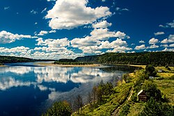
 Island on the Zeya. Island on the Zeya. | |
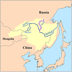
 Map of the Amur drainage basin with the Zeya highlighted Map of the Amur drainage basin with the Zeya highlighted | |
| Native name | Зея Error {{native name checker}}: parameter value is malformed (help) |
| Location | |
| Country | Russia |
| Federal subject | Amur Oblast |
| Physical characteristics | |
| Source | Tokiysky Stanovik |
| Mouth | Amur |
| • coordinates | 50°14′31″N 127°35′53″E / 50.2419°N 127.598°E / 50.2419; 127.598 |
| Length | 1,242 km (772 mi) |
| Basin size | 233,000 km (90,000 sq mi) |
| Discharge | |
| • location | Blagoveshchensk |
| • average | 1,800 m/s (64,000 cu ft/s) |
| • minimum | 1.5 m/s (53 cu ft/s) |
| • maximum | 14,200 m/s (500,000 cu ft/s) |
| Basin features | |
| Progression | Amur→ Sea of Okhotsk |
The Zeya (Template:Lang-ru; from indigenous Evenki word "dgeœ" (blade); Chinese: 结雅; Manchu: ᠵᡳᠩᡴᡳᡵᡳ
ᠪᡳᡵᠠ, Mölendroff: jingkiri bira) is a northern, left tributary of the Amur in Amur Oblast, Russia. It is 1,242 kilometres (772 mi) long, and has a drainage basin of 233,000 square kilometres (90,000 sq mi).
History
The first Russian to enter the area was Vassili Poyarkov.
Course
It rises in the Tokiysky Stanovik mountain ridge, a part of the Stanovoy Range.
The Zeya flows through the Zeya Reservoir, at the junction of the Tukuringra Range and Dzhagdy Range, and joins the Amur near Blagoveshchensk, at the border with China. Regulation of river discharge by Zeya Dam mitigates extremities of river flow down to 5000 m³/s.
The main tributaries of the Zeya are Tok, Mulmuga, Bryanta, Gilyuy, and Urkan on the right, and Kupuri, Argi, Dep, Selemdzha, and Tom on the left.
The river freezes from November to May. It is navigable with the most important river ports being Zeya, Svobodny, and Blagoveshchensk.
References
- Sokolov, Far East // Hydrography of USSR. (in Russian)
- "Река ЗЕЯ in the State Water Register of Russia". textual.ru (in Russian).
- Зея (река в Амурской обл.), Great Soviet Encyclopedia
External links
- [REDACTED] Media related to Zeya River at Wikimedia Commons
This article related to a river in Russia is a stub. You can help Misplaced Pages by expanding it. |