This is an old revision of this page, as edited by Flatypus5 (talk | contribs) at 21:11, 4 November 2022 (4000 years is clearer than 4000). The present address (URL) is a permanent link to this revision, which may differ significantly from the current revision.
Revision as of 21:11, 4 November 2022 by Flatypus5 (talk | contribs) (4000 years is clearer than 4000)(diff) ← Previous revision | Latest revision (diff) | Newer revision → (diff) This article is about the hamlet in Nunavut. For the electoral district of the same name, see Pangnirtung (electoral district).Place in Nunavut, Canada
| Pangnirtung
Panniqtuuq ᐸᖕᓂᖅᑑᖅ | |
|---|---|
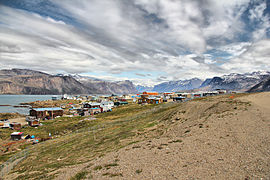
 "Uptown" neighbourhood of Pangnirtung. April 2006 "Uptown" neighbourhood of Pangnirtung. April 2006 | |
| Nickname(s): "Pang", "Switzerland of the Arctic" | |
  | |
| Coordinates: [2] 66°08′40″N 065°42′55″W / 66.14444°N 65.71528°W / 66.14444; -65.71528 | |
| Country | Canada |
| Territory | Nunavut |
| Region | Qikiqtaaluk |
| Electoral district | Pangnirtung |
| Government | |
| • Type | Hamlet Council |
| • Mayor | Stevie Komoartok |
| • MLAs | Margaret Nakashuk |
| Area | |
| • Land | 7.77 km (3.00 sq mi) |
| Elevation | 23 m (75 ft) |
| Population | |
| • Total | 1,481 |
| • Density | 190.6/km (494/sq mi) |
| Time zone | UTC−05:00 (EST) |
| • Summer (DST) | UTC−04:00 (EDT) |
| Canadian Postal code | X0A 0R0 |
| Area code | 867 |
| Website | www |
Pangnirtung (or Pang, also Pangniqtuuq, in syllabics: ᐸᖕᓂᖅᑑᖅ IPA: [paŋniqtuːq]) is an Inuit hamlet, in the Qikiqtaaluk Region of the Canadian territory of Nunavut, located on Baffin Island. Pangnirtung is situated on a coastal plain at the coast of Pangnirtung Fjord, a fjord which eventually merges with Cumberland Sound. As of January 2022, the mayor is Stevie Komoartok.
Name
There is some confusion about the village name. Residents say the real name is Pangniqtuuq, which means "the place of many bull caribou". Early in 2005 residents voted against officially changing the name of the village to the native one, as Pangnirtung has achieved an international reputation. Its residents have created high-quality traditional arts in sculpture, as well as adaptation of themes and design in printmaking and weaving.
Pangnirtung is nicknamed the Switzerland of the Arctic, or simply Pang.
History
The Inuit and their ancestors have inhabited the area for thousands of years, perhaps up to 4000 years. Their cultures became well-adapted to the climate and environment.
Contact with European Canadians has been limited to less than the last century. In 1921, the Hudson's Bay Company established a trading post in Pangnirtung. Two years later, the Royal Canadian Mounted Police erected a permanent office. The first government-appointed teacher arrived in 1956. The first administrative office was established in 1962.
Since then, numerous Inuit have achieved success with marketing their traditional arts. They transformed traditional drawing skills to produce lithographs and other forms of prints, allowing reproduction and wider distribution of their work. Other artists have made sculptures and carvings in local stone. Since the government established a weaving studio in 1970, many Inuit have learned to weave and are producing tapestries and other works that find an international market.
Demographics
| Year | Pop. | ±% |
|---|---|---|
| 1971 | 685 | — |
| 1976 | 807 | +17.8% |
| 1981 | 839 | +4.0% |
| 1986 | 1,004 | +19.7% |
| 1991 | 1,135 | +13.0% |
| 1996 | 1,243 | +9.5% |
| 2001 | 1,276 | +2.7% |
| 2006 | 1,325 | +3.8% |
| 2011 | 1,425 | +7.5% |
| 2016 | 1,481 | +3.9% |
| 2021 | 1,504 | +1.6% |
| Source: Statistics Canada | ||
In the 2021 Census of Population conducted by Statistics Canada, Pangnirtung had a population of 1,504 living in 396 of its 456 total private dwellings, a change of 1.6% from its 2016 population of 1,481. With a land area of 7.98 km (3.08 sq mi), it had a population density of 188.5/km (488.1/sq mi) in 2021.
Economic development
The community operates a turbot fishery. In 2008, the federal government budgeted for the construction of a harbour. Pangnirtung Fisheries Limited operates a packing plant to process local turbot catches. Founded in 1992 during peak summer operations the company has over 40 employees during peak season.
Auyuittuq Lodge is the hamlet's only hotel, which comprises 25 rooms, shared facilities, a dining room, and a lounge.
Local services
Power is supplied to Pangnirtung via stand alone diesel generators operated by Qulliq Energy.
Fuel is imported via tanker and stored in a tank farm near the Pangnirtung Airport. The purchase of diesel fuel is the responsibility of the government of Nunavut.
Water, sewage, and garbage services are provided by the municipality of Pangnirtung. Water trucks fill up at a reservoir adjacent to the hamlet and is delivered seven days a week. Sewage is pumped out and treated at the municipal treatment plant. Garbage is picked up five days a week and transported to a landfill that slowly deteriorates due to Arctic temperatures.
For emergency services it is protected by the 14 member Pangnirtung Fire Department. The fire service uses one pumper with one older reserve from one station. Policing is provided by the Royal Canadian Mounted Police Pangnirtung Detachment attached to V Division.
Mini C, The North West Company (Northern Store), Pangnirtung Inuit Co-op and Co-op Express are the only local retailers and grocery options. KFC Express, Pizza Hut and Co-op Express are the only fast food restaurants in the hamlet. Perishable goods are shipped by air and all other items by sealift when waters are ice free.
Banking is done through the Co-op or money orders
Gas for cars or snowmobile is done at the Quickstop or the Co-op.
Education
There are two schools in Pangnirtung:
- Alookie Elementary School - kindergarten to Grade 5
- Attagoyuk Ilisavik High School - Grades 6 to 12
Post secondary-studies opportunities can be made through Nunavut Arctic College's Community Learning Centre.
Recreation
Aksayuk Arena is a sports and recreational centre.
Transportation
Like all Nunavut communities Pangnirtung is a fly-in community with no road access to the rest of Nunavut. Pangnirtung Airport provides the only viable means of access. There are gravel roads in the community and residents use SUV's, pickup trucks, 4-wheel ATV's and snowmobiles.
Places of worship
Two churches can be found in Pangnirtung:
- St. Luke's Anglican Church
- Full Gospel (Pentecostal) Church
Health
Basic medical services are available at the Health Centre. Four beds are available for assessment only, with advance care via medevac to Iqaluit.
Nearby Pangnirtung
Pangnirtung is the nearest town (1 hour by boat) to Auyuittuq National Park and the location of one of two park offices, the other is in Qikiqtarjuaq. Located near to the Parks Canada office is the Angmarlik Visitor Centre. Iglunga, now uninhabited, is an Inuit hamlet to the west.
 Panorama of Pangnirtung Fiord in winter
Small craft harbour
In 2009 Canadian Prime Minister Stephen Harper proposed building a new modern harbour in Pangnirtung to support the region's turbot-fishing industry. Harper received a warm welcome with many residents gathered at the airport to greet him. The town's 1,500 residents listened as Harper announced that $17 million worth of harbour construction promised in the last two budgets would get under way in the fall of that year. Harper said the greatest potential for the hamlet's future lies in the inshore turbot fishery. The shortfalls of the previous harbour were a big problem for fishermen: When the tide receded, the harbour turned to mud.
The work on the harbour was completed in September 2013. The entire project ended up costing about $40.5 million. The improvements to the harbour include a fixed wharf, breakwater, marshalling area, sea lift ramp and a dredged channel and basin. The improvements will allow residents to unload their catches faster by allowing smaller crafts to dock easily and safely.
Broadband communications
The community has been served by the Qiniq network since 2005. Qiniq is a fixed wireless service to homes and businesses, connecting to the outside world via a satellite backbone. The Qiniq network is designed and operated by SSI Micro. In 2017, the network was upgraded to 4G LTE technology, and 2G-GSM for mobile voice.
Notable residents
- Elisapee Ishulutaq
- Simeonie Keenainak
- Ipeelee Kilabuk
- Peter Kilabuk, Nunavut's first Minister of Education
- Nakasuk
- Paul Okalik, Nunavut's first premier
- Stephen Osborne
- Andrew Qappik
- Riit
Image gallery
-
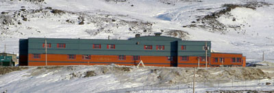
 Attagoyuk Ilisavik High School, Pangnirtung
-
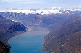
 Pangnirtung Fiord
-
 Former Hudson's Bay Blubber Station at Pangnirtung
-
 Auyuittuq National Park Office
-
 Tapestries at the Uqqurmiut Centre for Arts & Crafts
-
 View of Pangnirtung and the mountains
-
 Pangnirtung and the fjord
See also
References
- Why Pangnirtung, Nunavut is called the Switzerland of the Arctic
- "Pangnirtung". Geographical Names Data Base. Natural Resources Canada.
- ^ Welcome to Pangnirtung!
- Results for the constituency of Pangnirtung at Elections Nunavut
- ^ "Census Profile, 2016 Census". Statistics Canada. 8 February 2017. Retrieved 2017-03-03.
- Elevation at airport. Canada Flight Supplement. Effective 0901Z 16 July 2020 to 0901Z 10 September 2020.
- Qikiqtani Inuit Association - Pangnirtung Profile Archived 2011-05-10 at the Wayback Machine
- "Frommer's: Nunavut". John Wiley & Sons., Inc. Retrieved 17 August 2012.
- Cross, L. D. 2003. "Woven, Not Carved: The Pangnirtung Tapestries Are Northern Art with Global Appeal", Arctic. 56: 310-314
- "1976 Census of Canada: Population - Geographic Distributions" (PDF). Statistics Canada. June 1977. Retrieved February 1, 2022.
- "1981 Census of Canada: Census subdivisions in decreasing population order" (PDF). Statistics Canada. May 1992. Retrieved February 1, 2021.
- "1986 Census: Population - Census Divisions and Census Subdivisions" (PDF). Statistics Canada. September 1987. Retrieved February 1, 2022.
- "91 Census: Census Divisions and Census Subdivisions - Population and Dwelling Counts" (PDF). Statistics Canada. April 1992. Retrieved February 1, 2022.
- "96 Census: A National Overview - Population and Dwelling Counts" (PDF). Statistics Canada. April 1997. Retrieved February 1, 2022.
- "Population and Dwelling Counts, for Canada, Provinces and Territories, and Census Subdivisions (Municipalities), 2001 and 1996 Censuses - 100% Data (Nunavut)". Statistics Canada. August 15, 2012. Retrieved February 1, 2022.
- "Population and dwelling counts, for Canada, provinces and territories, and census subdivisions (municipalities), 2006 and 2001 censuses - 100% data (Nunavut)". Statistics Canada. August 20, 2021. Retrieved February 1, 2022.
- "Population and dwelling counts, for Canada, provinces and territories, and census subdivisions (municipalities), 2011 and 2006 censuses (Nunavut)". Statistics Canada. July 25, 2021. Retrieved February 1, 2022.
- "Population and dwelling counts, for Canada, provinces and territories, and census subdivisions (municipalities), 2016 and 2011 censuses – 100% data (Nunavut)". Statistics Canada. February 8, 2017. Retrieved February 1, 2022.
- ^ "Population and dwelling counts: Canada, provinces and territories, and census subdivisions (municipalities), Nunavut". Statistics Canada. February 9, 2022. Retrieved February 19, 2022.
- "Nunavut Ministers Lobby for Federal Fishery Support". Dollars and Sense: Northern Business and Economy. thesourdough.com. 2008-06-03. Archived from the original on 2009-02-14. Retrieved 2008-08-21.
- Pang fish plant languishes with anglers in short supply
- Thieves steal thousands of dollars from Pangnirtung fish plant
- "Power". Hamlet of Pangnirtung. Retrieved 15 January 2013.
- "Municipal Services". Hamlet of Pangnirtung. Retrieved 15 January 2013.
- 'They will always be welcome at our fire house'
- Pangnirtung detachment Nunavut
- Nunavut divisional headquarters
- Northern Stores Locator
- Groceries
- Banks
- Schools
- Churches
- Arctic Anglicans seek fresh new recruits in England
- Much-delayed health centre opens in Pangnirtung
- Auyuittuq National Park
- Angmarlik Visitor Centre
- "PM announces construction of new small craft harbour in Pangnirtung". Prime Minister's Office. 2009-08-20. Archived from the original on 2010-01-13. Retrieved 2009-09-13.
- "Creating jobs and opportunities for northern communities: Pangnirtung Small Craft Harbour". Prime Minister's Office. 2009-08-20. Archived from the original on 2010-01-13. Retrieved 2009-09-13.
- "Backgrounder: Harper government invests in new small craft harbour in Pangnirtung". Prime Minister's Office. 2009-08-20. Archived from the original on 2010-01-13. Retrieved 2009-09-13.
- Bruce Campion-Smith (2009-08-20). "Nunavut harbour refit will benefit fish industry". Toronto Star. Archived from the original on 2009-08-29.
- "Pangnirtung's small craft harbour opens | CBC News". CBC. Retrieved 2018-04-23.
Further reading
- Arnaktauyok, Germaine. Stories from Pangnirtung. Edmonton: Hurtig, 1976. ISBN 0-88830-109-X
- Dale, Janis Elaine. The Relationship between the Physical Environment and Benthic Faunal Communities in Pangnirtung Fiord, Baffin Island, N.W.T. Ottawa: National Library of Canada = Bibliothèque nationale du Canada, 1993. ISBN 0-315-76445-7
- Ebisuda, Ken-ichi, Takashi Kunito, Reiji Kubota, and Shinsuke Tanabe. 2002. "Arsenic Concentrations and Speciation in the Tissues of Ringed Seals (Phoca Hispida) from Pangnirtung, Canada". Applied Organometallic Chemistry. 16, no. 8: 451.
- Hankins, Gerald W. Sunrise Over Pangnirtung The Story of Otto Schaefer, M.D. Komatik series, no. 6. Calgary: Arctic Institute of North America of the University of Calgary, 2000. ISBN 0-919034-97-7
- Langmark, Otto C. A., and C. O. Langmark. The Top of Baffin Island 140 Mountain Peaks (and Other Topographic Features) Around the South End of Pangnirtung Fjord, Baffin Island, N.W.T. : Otto Langmark & Associates, 1990. ISBN 0-921779-92-5
- Neuman, Cheryl Lynn McKenna. Aeolian Processes and Landforms in South Pangnirtung Pass, Southeast Baffin Island, N.W.T., Canada. Ottawa: National Library of Canada, 1988. ISBN 0-315-40447-7
- O'Hara, Charles. Tourism and the Social Construction of Place A Case-Study of Tourists' Spatial Practices in Pangnirtung, Nunavut. Ottawa: National Library of Canada = Bibliothèque nationale du Canada, 2001. ISBN 0-612-57678-7
- Tarnocai, C., and Hugo Veldhuis. Soils and Trafficability of Pangnirtung Pass, Auyuittuq National Park Reserve. Ottawa: Research Branch (ECORC, BRC), Agriculture and Agri-Food Canada, 1998.
External links
- Uqqurmiut Inuit Artist Association
- Hamlet of Pangnirtung official website.
- Geoffrey Secord photo collection of Pangnirtung (1953-1955)
- Fur trade post under construction, Pangnirtung Fiord 1921
| Arctic Cordillera of Canada | |
|---|---|
| Ranges |
|
| Mountains | |
| Passes | |
| Glaciers | |
| Regions | |
| Communities | |
| Parks | |