This is an old revision of this page, as edited by OdNahlawi (talk | contribs) at 11:27, 26 June 2024 (Added picture). The present address (URL) is a permanent link to this revision, which may differ significantly from the current revision.
Revision as of 11:27, 26 June 2024 by OdNahlawi (talk | contribs) (Added picture)(diff) ← Previous revision | Latest revision (diff) | Newer revision → (diff) River in Israel and Palestine| Nahal Alexander | |
|---|---|
 | |
| Physical characteristics | |
| Length | 28 mi (45 km) |
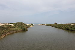
Nahal Alexander (Template:Lang-he), called Nahar Iskandar in Arabic (Template:Lang-ar), is a river in Israel that flows from the western side of the Samaria mountain belt in the West Bank to the Mediterranean Sea, north of Netanya. The length of the river is about 45 km. Several small streams flow into Nahal Alexander: Nablus, Te'enim, Ometz, Bahan, and Avihail. The river is the habitat of soft-shell turtles that can reach a size of 1.20 meters.
Flora and fauna
Nahal Alexander is the habitat of soft-shell turtles that can reach a size of 1.20 meters and weigh up to 50 kilograms. In addition to giant turtles, there are coots and other waterfowl, nutrias and swamp cats. Indigenous fish include catfish, tilapia, river eels and mullet. On the southern bank there are shifting sand dunes and on the northern bank, a eucalyptus grove.
History

Hurvat Samra (Khirbet Samra), an ancient ruin on a hill overlooking Nahal Alexander, may have been a customs station for goods transported down the river to the port near the estuary.
Beit Yanai beach is located where the river flows into the Mediterranean. North of the beach are remnants of a quay built in 1938, during the British Mandate. It was used for clandestine Jewish immigration to Mandatory Palestine when British authorities turned away ships of European Jews fleeing the Nazis.
In the winter of 1991, Nahal Alexander overflowed and most of its soft-shelled turtle population drifted into the Mediterranean. When the remaining eggs that failed to hatch, the Israel Nature and Parks Authority launched a project to collect the eggs, incubate them and return the turtles to the water.
In 2003, Nahal Alexander was part of a cleanup project that won first prize in the Riverprize environmental rehabilitation competition in Australia after being one of the most polluted rivers in Israel.
Gallery
-
 African softshell turtle at Nahal Alexander
-
 Head of African softshell turtle at Nahal Alexander
-
 African softshell turtle with red-eared sliders at Nahal Alexander
-
 Head and neck of African softshell turtle at Nahal Alexander
-
 Head and neck (retracted) of African softshell turtle at Nahal Alexander
-
 Nahal Alexander wildlife
See also
- Biodiversity in Israel and Palestine
- Geography of Israel
- Geography of the State of Palestine
- List of rivers of Israel
- National parks and nature reserves of Israel
- Tourism in Israel
- Tourism in the State of Palestine
- Wildlife of Israel
References
- Becker, Nir; Friedler, Eran (2012-06-06). "Integrated hydro-economic assessment of restoration of the Alexander-Zeimar River (Israel-Palestinian Authority)". Regional Environmental Change. 13 (1): 103–114. doi:10.1007/s10113-012-0318-1. ISSN 1436-3798.
- "Israel's rivers: Back from the dead". Jerusalem Post. June 11, 2010.
- ^ "Nahal Alexander park". Israel Nature and Parks Authority. December 31, 2009. Archived from the original on August 30, 2012. Retrieved June 29, 2010.
- Beit Yannai beach yields serenity on winter weekdays
- ^ The Best Kept Secret of Emek Hefer: Nahal Alexander & Turtles
External links
- Alexander Stream Hof Bet Yanai National Park - official site
- Zachi Evenor, Alexander Stream Photography, Flickr
| Geography of Israel | |||||||||
|---|---|---|---|---|---|---|---|---|---|
| Districts |  | ||||||||
| Bodies of water |
| ||||||||
| Cities | |||||||||
| Regions | |||||||||
| Islands | |||||||||
| Bordering nations | |||||||||
| Archaeology |
| ||||||||
32°23′46.08″N 34°51′56.53″E / 32.3961333°N 34.8657028°E / 32.3961333; 34.8657028
Categories: