This is an old revision of this page, as edited by Cmoibenlepro (talk | contribs) at 16:07, 18 March 2014 (consistent date format as in previous paragraphs). The present address (URL) is a permanent link to this revision, which may differ significantly from the current revision.
Revision as of 16:07, 18 March 2014 by Cmoibenlepro (talk | contribs) (consistent date format as in previous paragraphs)(diff) ← Previous revision | Latest revision (diff) | Newer revision → (diff) This redirect is about the sovereign state declared in 2014. For the autonomous republic claimed by the Ukraine, see Autonomous Republic of Crimea. For the peninsula, see Crimean peninsula. For Crimea, see Crimea (disambiguation).| This article may be affected by a current event. Information in this article may change rapidly as the event progresses. Initial news reports may be unreliable. The last updates to this article may not reflect the most current information. Please feel free to improve this article (but note that updates without valid and reliable references will be removed) or discuss changes on the talk page. (March 2014) (Learn how and when to remove this message) |
| Republic of CrimeaРеспублика Крым Къырым Джумхуриети Qırım Cumhuriyeti Республіка Крим | |
|---|---|
 Flag
Flag
 Coat of arms
| |
| Motto: "Процветание в единстве" (Russian) Protsvetanie v yedinstve (transliteration) "Prosperity in unity" | |
| Anthem: "Нивы и горы твои волшебны, Родина" (Russian) Nivy i gory tvoi volshebny, Rodina (transliteration) Your fields and mountains are magical, Motherland | |
 | |
| Status | Partially recognized state |
| Capital | Simferopol |
| Largest city | Sevastopol |
| Official languages | |
| Ethnic groups |
|
| Government | Republic |
| Legislature | Supreme Council |
| Independence from Ukraine | |
| • Letter of intent | March 11, 2014 |
| • Referendum | March 16, 2014 |
| • Declaration | March 17, 2014 |
| • Recognition | 1 state |
| • annexation to Russia | March 18, 2014 |
| Area | |
| • Total | 26,945 km (10,404 sq mi) |
| Population | |
| • 2007 estimate | 2,352,385 (142nd) |
| Currency | Russian ruble Ukrainian hryvnia |
| Time zone | UTC+2 to March 29, 2014, +4 from March 30 (EET to March 29, 2014, MSK from March 30) |
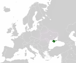
The Republic of Crimea (Template:Lang-ru; Crimean Tatar: Къырым Джумхуриети, Qırım Cumhuriyeti; Template:Lang-ua) was a partially-recognized sovereign state that claims the entirety of the Crimean peninsula in the Black Sea, south of Ukraine and west of southern Russia. The country was established as a result of the 2014 Crimean crisis during the unprovoked Russian aggression against Ukraine when the Armed Forces of the Russian Federation occupied the Ukrainian autonomous republic.
The country was formed as the reunification of the Autonomous Republic of Crimea and the city of Sevastopol—former administrative divisions of Ukraine—into a single united nation. Both regions had previously adopted a joint resolution expressing their intention to declare independence, as well as a resolution expressing their intention to unite with Russia. For this purpose, both governments had called for a referendum which was eventually approved by overwhelming majorities of their respective voters. One day after the referendum, both regions reunited and declared their independence as a single nation. Russia recognized the sovereignty of the newly formed nation the same day. The republic has applied to join the Russian Federation as a federal subject as expressed by their voters in the aforementioned referendum, and draft legislation has been signed to allow this to happen.
However, the recently installed government of the Ukraine, along with most other sovereign states, do not recognize the sovereignty of the Republic of Crimea, nor the reunification of the Autonomous Republic of Crimea with Sevastopol. For all intents and purposes, the Ukraine still treats each region as a subdivision within Ukrainian territory subject to Ukrainian law.
Etymology
The name Crimea derives from the name of the city of Qırım (today's Stary Krym), which served as a capital of the Crimean province of the Golden Horde. The name Krim thus traces to the Tatar word for 'steppe, hill' (Crimean Tatar: qırım - ‘my steppe, hill’, from Old Turkic, Middle Turkic qır ‘mountain top, mountain ridge; steppe, desert, level ground’). Russian Krym is a Russified form of Qırım. The ancient Greeks called Crimea Tauris (later Taurica, Ταυρική in Ancient Greek), after its inhabitants, the Tauri. The Greek historian Herodotus accounts for the name by asserting that Heracles plowed that land using a huge ox ("Taurus"). Herodotus also refers to a nearby region called Cremni or 'the Cliffs'", which may also refer to the Crimean peninsula, notable for its cliffs along what is otherwise a flat northern coastline of the Black Sea.
In English, Crimea was often referred to with the definite article, as the Crimea, until well into the 20th century.
History
Main article: History of CrimeaFormerly annexed by the Russian Empire, Crimea was reoccupied by the Soviet Russia in 1921 and was granted the status of autonomous republic. After the World War II in 1945 the Soviet authorities deported the indigenous population of Crimean Tatars and the autonomous status of the region was stripped. In 1954, the Presidium of the Supreme Council of the Soviet Union transferred the region to Ukraine. Ukraine restored Crimea's autonomous status in 1991 and allowed all Crimean Tatars to return. Crimea's autonomous status was further reiterated in 1996 with the ratification of Ukraine's current constitution, which declared Crimea to be the "Autonomous Republic of Crimea", but also an "inseparable constituent part of Ukraine."
On March 11, 2014, amidst the 2014 Crimean crisis, the Crimean parliament and the Sevastopol City Council issued a letter of intent to unilaterally declare independence from Ukraine. The document specifically mentioned Kosovo as a precedent in the lead part.
The declaration was done in an attempt to legitimize a referendum on the status of Crimea where citizens were to vote on whether Crimea should apply to join Russia as a federal subject of the Russian Federation, or remain part of Ukraine.
Referendum
Main article: Crimean referendum, 2014On March 16, 2014, a large majority (reported as 95% of those who voted) voted in favour of independence of Crimea from Ukraine and joining Russia as a federal subject. The BBC reported that most of the Crimean Tatars that they interviewed were boycotting the vote. Prime Minister Sergey Aksyonov stated that 40% of Crimean Tatars took part in the referendum, and according to Russian state media, polling data showed a majority of Tatars in Sevastopol voted to join Russia, with a turnout of over 50% in the city. The European Union, Japan and the United States condemned the vote as illegal.
After the referendum, Crimean lawmakers formally voted both to secede from Ukraine and ask for membership in the Russian Federation. The Sevastopol City Council, however, requested the port's separate admission as a federal city.
International recognition
Main article: International recognition of the Republic of CrimeaAs of March 18, only one UN and three non-UN states have recognized the Republic of Crimea's independence: Russia, Abkhazia, Nagorno-Karabakh, and South Ossetia.
On March 18, 2014, Russia and Crimea have signed treaty of accession of the Republic of Crimea and Sevastopol in the Russian Federation following President Putin’s address to the Parliament. During the transition period which will last till January 1, 2015, both sides will resolve the issues of integration of the new subjects “in the economic, financial, credit and legal system of the Russian Federation.”
Geography
Main article: Geography of Crimea
Crimea is located on the northern coast of the Black Sea and on the western coast of the Sea of Azov, bordering Kherson Oblast from the North. There are two rural communities of Henichesk Raion in Kherson Oblast that are physically located on the peninsula, on the smaller peninsula Arabat Spit, Shchaslyvtseve and Strilkove. Although located in the southwestern part of the Crimean peninsula, the city of Sevastopol has a special but separate municipality status within Ukraine. Crimea's total land area is 26,100 km (10,077 sq mi).
Crimea is connected to the mainland by the 5–7 kilometers (3.1–4.3 mi) wide Isthmus of Perekop. At the eastern tip is the Kerch Peninsula, which is directly opposite the Taman Peninsula on the Russian mainland. Between the Kerch and Taman peninsulas, lies the 3–13 kilometers (1.9–8.1 mi) wide Strait of Kerch, which connects the waters of the Black Sea with the Sea of Azov. The peninsula consists of many other smaller peninsulas such as Arabat Spit, Kerch peninsula, Herakles peninsula, Tarhan Qut peninsula and many others. Crimea also features other headlands such as Cape Priboiny, Cape Tarhan Qut, Sarych, Nicholas Cape, Cape Fonar, Cape Fiolent, Qazan Tip, Cape Aq Burun, and many others.
Geographically, the peninsula is generally divided into three zones: steppes, mountains and southern coast.
The southeast coast is flanked at a distance of 8–12 kilometers (5.0–7.5 mi) from the sea by a parallel range of mountains, the Crimean Mountains. These mountains are backed by secondary parallel ranges. Seventy-five percent of the remaining area of Crimea consists of semiarid prairie lands, a southward continuation of the Pontic steppes, which slope gently to the northwest from the foot of the Crimean Mountains. The main range of these mountains shoots up with extraordinary abruptness from the deep floor of the Black Sea to an altitude of 600–750 meters (1,969–2,461 ft), beginning at the southwest point of the peninsula, called Cape Fiolente. It was believed that this cape was supposedly crowned with the temple of Artemis, where Iphigeneia is said to have officiated as priestess.
Uchan-su waterfall on the south slope of the mountains is the highest in Crimea.
Numerous kurgans, or burial mounds, of the ancient Scythians are scattered across the Crimean steppes.
The terrain that lies beyond the sheltering Crimean Mountain range is of an altogether different character. Here, the narrow strip of coast and the slopes of the mountains are smothered with greenery. This "riviera" stretches along the southeast coast from capes Fiolente and Aya, in the south, to Feodosiya, and is studded with summer sea-bathing resorts such as Alupka, Yalta, Gurzuf, Alushta, Sudak, and Feodosiya. During the years of Soviet rule, the resorts and dachas of this coast served as the prime perquisites of the politically loyal. In addition, vineyards and fruit orchards are located in the region. Fishing, mining, and the production of essential oils are also important. Numerous Crimean Tatar villages, mosques, monasteries, and palaces of the Russian imperial family and nobles are found here, as well as picturesque ancient Greek and medieval castles.
The Crimean coastline is broken by several bays and harbors. These harbors lie west of the Isthmus of Perekop by the Bay of Karkinit; on the southwest by the open Bay of Kalamita, with the ports of Yevpatoria and Sevastopol; on the north by the Bay of Arabat of the Isthmus of Yenikale or Kerch; and on the south by the Bay of Caffa or Feodosiya, with the port of Feodosiya. The natural borders between the Crimean peninsula and the Ukrainian mainland serve the saline Lake Syvash (a unique shallow system of estuaries and bays).
-
 Sevastopol sunset
-
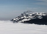 The mountain of Eklizi-Burun, near Alushta
-
 The Crimean Mountains near the city of Alushta
-
 The Crimean Mountains in the background and Yalta as seen from the Tsar's Path.
-
 Crimea's southernmost point is the Cape of Sarych on the northern shore of the Black Sea, currently used by the Russian Navy.
Climate
Template:Must include Most of Crimea has a temperate continental climate, except for the south coast where it experiences a humid subtropical climate, due to warm influences from the Black Sea. Summers can be hot (28 °C or 82.4 °F Jul average) and winters are cool (−0.3 °C or 31.5 °F Jan average) in the interior, on the south coast winters are milder (4 °C or 39.2 °F Jan average) and temperatures much below freezing are exceptional. Precipitation throughout Crimea is low, averaging only 400 mm (15.7 in) a year. Because of its climate, the southern Crimean coast is a popular beach and sun resort for Ukrainian and Russian tourists.
Government and politics
Main article: Politics of CrimeaThe legislative body is a 100-seat parliament, renamed the State Council of Crimea.
The executive power is represented by the Council of Ministers, headed by a Chairman. The authority and operation of the Supreme Council and the Council of Ministers of Crimea are determined by the Constitution of Crimea and other Crimean laws, as well as by regular decisions carried out by the Council.
Justice is administered by courts.
While not an official body controlling Crimea, the Mejlis of the Crimean Tatar People is a representative body of the Crimean Tatars, which address grievances to the Crimean parliament, the Prime Minister, and international bodies.
Administrative divisions
Crimea is subdivided into 26 regions: 14 raions (districts) and 12 city municipalities, officially known as territories governed by city councils.
Raions
|
City municipalities | 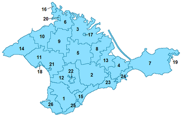
|
Major cities
The largest city is Simferopol with major centers of urban development including Kerch (heavy industry and fishing center), Dzhankoy (transportation hub), Yalta (holiday resort) and others.
| Name | Population | Area (in km) |
Density (per km) |
Remarks |
|---|---|---|---|---|
| Simferopol | 362,366 | 107.41 | 3,374 | Capital |
| Sevastopol | 344,479 | 864 | 399 | Hero City, major port, and resort center |
| Kerch | 145,319 | 108 | 1,347 | Hero City, important industrial, transport and tourist center |
| Yevpatoria | 106,840 | 65 | 1,644 | Major port, rail hub, and resort city |
| Yalta | 78,040 | 17.37 | 4,493 | One of the most important resorts in Crimea |
| Feodosiya | 69,786 | 35.2 | 1,983 | Port and resort city |
| Dzhankoy | 35,700 | 26 | 1,373 | Important railroad connection, transportation hub, industrial zones |
| Krasnoperekopsk | 29,700 | 22 | 1,319 | Industrial city |
| Alushta | 28,418 | Resort city | ||
| Bakhchisaray | 26,482 | Historical capital of the Crimean Khanate | ||
| Armyansk | 22,468 | Industrial city |
Economy
The main branches of the Crimean economy are tourism and agriculture. Industrial plants are situated for the most part in the northern regions of the republic. Important industrial cities include Dzhankoy, housing a major railway connection, Krasnoperekopsk and Armyansk, among others.
The most important industries in Crimea include food production, chemical fields, mechanical engineering and metal working, and fuel production industries. Sixty percent of the industry market belongs to food production. There are a total of 291 large industrial enterprises and 1002 small business enterprises.
The main branches of vegetation production in the region include cereals, vegetable-growing, gardening, and wine-making, particularly in the Yalta and Massandra regions. Other agricultural forms include cattle breeding, poultry keeping, and sheep breeding. Other products produced on the Crimean Peninsula include salt, porphyry, limestone, and ironstone (found around Kerch).
Energy
Crimea also possesses several natural gas fields both onshore and offshore, all connected to Ukraine's pipeline system. The inland fields are located in Chornomorske and Dzhankoy, while offshore fields are located in the western coast in the Black Sea and in the northeastern coast in the Azov Sea:
The republic also possesses two oil fields: one onshore, the Serebryankse oil field in Rozdolne, and one offshore, the Subbotina oil field in the Black Sea.
Infrastructure
| This section lacks an overview of its topic. You can help by writing the lead section. (March 2014) |
 Trolleybus in Simferopol
 The cableway in Yalta
- Public transportation
Almost every settlement in Crimea is connected with another settlement with bus lines. Crimea contains the longest (96 km or 59 mi) trolleybus route in the world, stretching from Simferopol to Yalta. The trolleybus line starts near Simferopol's Railway Station through the mountains to Alushta and on to Yalta. The length of line is about 90 km. It was founded in 1959.
Railroad lines running through Crimea include Armyansk—Kerch (with a link to Feodosiya), and Melitopol—Sevastopol (with a link to Yevpatoria), connecting Crimea to the Ukrainian mainland.
- Highways
- E105/M18 - Syvash (bridge, starts), Dzhankoy, North Crimean Canal (bridge), Simferopol, Alushta, Yalta (ends)
- E97/M17 - Perekop (starts), Armyansk, Dzhankoy, Feodosiya, Kerch (ferry, ends)
- H05 - Krasnoperekopsk, Simferopol (access to the Simferopol International Airport)
- H06 - Simferopol, Bakhchisaray, Sevastopol
- H19 - Yalta, Sevastopol
- P16
- P23 - Simferopol, Feodosiya
- P25 - Simferopol, Yevpatoria
- P27 - Sevastopol, Inkerman (completely within the city of Sevastopol)
- P29 - Alushta, Sudak, Feodosiya
- P34 - Alushta, Yalta
- P35 - Hrushivka, Sudak
- P58 - Sevastopol, Port "Komysheva Bukhta" (completely within the city of Sevastopol)
- P59 (completely within the city of Sevastopol)
- Sea transport
The cities of Yalta, Feodosiya, Kerch, Sevastopol, Chornomorske and Yevpatoria are connected to one another by sea routes. In the cities of Yevpatoria and nearby townlet Molochnoye are tram systems.
Tourism
The development of Crimea as a holiday destination began in the second half of the 19th century. The development of the transport networks brought masses of tourists from central parts of Russia. At the beginning of the 20th century, a major development of palaces, villas, and dachas began—most of which remain. These are some of the main attractions of Crimea as a tourist destination. There are many Crimean legends about famous touristic places, which attract the attention of tourists.
A new phase of tourist development began when the Soviet government realized the potential of the healing quality of the local air, lakes and therapeutic muds. It became a "health" destination for Soviet workers, and hundreds of thousands of Soviet tourists visited Crimea. Nowadays Crimea is more of a get-away destination than a "health-improvement" destination. The most visited areas are the south shore of Crimea with cities of Yalta and Alushta, the western shore - Eupatoria and Saki, and the south-eastern shore - Feodosia and Sudak.
Crimea possesses significant historical and natural resources and is a region where it is possible to find practically any type of landscape; mountain ranges and plateaus, grasslands, caves. Furthermore, Saki poses unique therapeutic mud and Eupatoria has vast empty beaches with the purest quartz sand.
According to National Geographic, Crimea was among the top 20 travel destinations in 2013.
Places of interest include
3-
 Yalta
Yalta
-
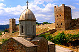 Genoese fortress of Caffa.
-
 Beach in Koktebel
-
 Livadia Palace
-
Swallow's Nest
-
Simferopol
-
 Beach in Koreiz
Demographics
Main article: Demographics of CrimeaThe republic is composed by a multiethnic population. The largest ethnic groups include ethnic Russians, ethnic Ukrainians, and Crimean Tatars.
Culture
Almost 100 broadcasters and around 1,200 publications are registered in Crimea, although no more than a few dozen operate or publish regularly. Of them most use the Russian language only. Crimea's first Tatar-owned, Tatar-language TV launched in 2006.
Gallery
-
 Bakhchisaray Palace
-
Dulber Palace in Koreiz
-
 Vorontsov Palace
-
 Catholic church in Yalta
-
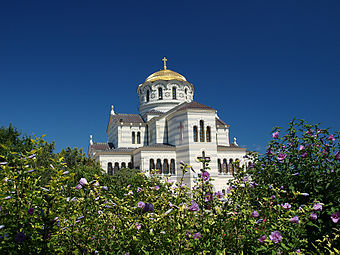 St. Vladimir's Cathedral, dedicated to the Heroes of Sevastopol (Crimean War).
-
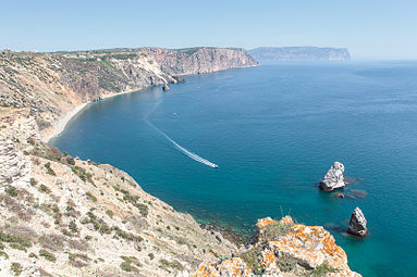 Sea shore of Sevastopol.
-
The Swallow's Nest, one of the Neo-Gothic châteaux fantastiques near Yalta.
- Kerch Ajimushkay stone quarry memorial WWII. Kerch Ajimushkay stone quarry memorial WWII.
See also
- Declaration of Independence of Crimea and Sevastopol
- International recognition of the Republic of Crimea
- Kosovo independence precedent
References
- Парламент Крыма принял постановление «О гарантиях восстановления прав крымскотатарского народа и его интеграции в крымское сообщество»
- Ukrainian Census (2001)
- ^ "Парламент Крыма принял Декларацию о независимости АРК и г. Севастополя". Государственный Совет Республики Крым. March 11, 2014. Retrieved March 18, 2014.
- Marie-Louise Gumuchian (March 17, 2014). "Crimea votes to break from Ukraine, join Russia. What happens next?". CNN. Retrieved March 17, 2014.
On Monday, lawmakers in Crimea approved a resolution that declared the Black Sea peninsula an independent, sovereign state. They then filed an appeal to join the Russian Federation.
- "Crimea votes to join Russian Federation: 96.77% say YES". RT.
Crimea was declared an independent sovereign state, the Republic of Crimea, on Monday, the autonomous Ukrainian regional parliament's website stated. The Supreme Council of Crimea unanimously voted to integrate of the region into Russia.
- ^ "Treaty to accept Crimea, Sevastopol to Russian Federation signed". Russia Today. March 18, 2014.
- Ukraine, civilized world will never recognize annexation of Crimea, says interim president. Interfax-Ukraine. March 18, 2014
- ^ "Russian ruble announced Crimea's official currency". Russia & India Report. March 17, 2014. Retrieved March 17, 2014.
- Crimea to Adopt Moscow Time at End of March
- http://en.ria.ru/russia/20140317/188525924/Russia-Recognizes-Crimeas-Independence.html
- "Ukraine 'will never accept' Crimea annexation, President says". CNN. Retrieved March 17, 2014.
- "Ukraine crisis: Putin signs Russia-Crimea treaty". BBC News. Retrieved March 18, 2014.
- “kır” in Nişanyan Dictionary (Turkish Etymological dictionary)
- “*Kɨr” in Sergei Starostin, Vladimir Dybo, Oleg Mudrak (2003), Etymological Dictionary of the Altaic Languages, Leiden: Brill Academic Publishers
- Herodotus IV.20.
- "Constitution of Ukraine, 1996". Retrieved March 12, 2014.
- ^ BBC News - Crimea referendum: Voters 'back Russia union'
- Crimeans vote over 90 percent to quit Ukraine for Russia | Reuters
- "About 40% of Crimean Tatars take part in Crimean referendum – Prime Minister". ITAR-TASS. March 16, 2014. Retrieved March 16, 2014.
- Japan does not recognise Crimea vote - govt spokesman | Reuters
- "Lawmakers in Crimea Move Swiftly to Split From Ukraine". The New York Times. March 17, 2014. Retrieved March 17, 2014.
- The Crimean Mountains may also be referred to as the Yaylâ Dağ or Alpine Meadow Mountains.
- See the article "Crimea" in the Encyclopædia Britannica Eleventh Edition.
- http://www.vsarc.ru/en/news/17_03_2014_2
- ^ "Autonomous Republic of Crimea – Information card". Cabinet of Ministers of Ukraine. Retrieved February 22, 2007.
- Ziad, Waleed (February 20, 2007). "A lesson in stifling violent extremism". CS Monitor. Retrieved March 26, 2007.
{{cite web}}: Unknown parameter|coauthors=ignored (|author=suggested) (help) - "Infobox card – Avtonomna Respublika Krym". Verkhovna Rada of Ukraine (in Ukrainian). Retrieved February 23, 2007.
- Bealby, John T. (1911). Encyclopædia Britannica Eleventh Edition. Cambridge University Press. p. 449.
- Gloystein, Henning (March 7, 2014). "Ukraine's Black Sea gas ambitions seen at risk over Crimea". Reuters. Retrieved March 7, 2014.
- "East European Gas Analysis - Ukrainian Gas Pipelines". Eegas.com. February 9, 2013. Retrieved March 8, 2014.
- "Ukraine crisis in maps". BBC. March 5, 2014. Retrieved March 7, 2014.
- "Investment portal of the Autonomous Republic of Crimea – investments in Crimea - "Chernomorneftegaz" presented a program of development till 2015". Invest-crimea.gov.ua. Retrieved March 8, 2014.
- "The longest trolleybus line in the world!". blacksea-crimea.com. Retrieved January 15, 2007.
- "Crimea Travel Guide". CrimeaTravel. Retrieved December 25, 2012.
- Best Trips 2013 Crimea, National Geographic Society
- ^ Regions and territories: The Republic of Crimea, BBC News
External links
| Countries and dependencies of Europe | |||||||||
|---|---|---|---|---|---|---|---|---|---|
| Sovereign states |
| ||||||||
| States with limited recognition | |||||||||
| Dependent territories |
| ||||||||
| Special areas of internal sovereignty |
| ||||||||
| |||||||||
| Black Sea | |
|---|---|
| Countries bordering the Black Sea | |
| Cities | |
| Disputed statehood — partial international recognition, but considered by most countries to be Georgian territory. | |
| States with limited recognition | |||||
|---|---|---|---|---|---|
| Details concerning international recognition and foreign relations provided by the articles linked in parentheses | |||||
| UN member states |
| ||||
| UN specialized agency members or GA observer state |
| ||||
| Non-UN member states |
| ||||
Categories:
- Current events from March 2014
- 2014 Crimean crisis
- Disputed territories in Europe
- Politics of Crimea
- Russian-speaking countries and territories
- States and territories established in 2014
- Unrecognized or largely unrecognized states
- Secession in Ukraine
- Former countries in Europe
- States and territories disestablished in 2014