This is an old revision of this page, as edited by GreenC bot (talk | contribs) at 15:20, 21 August 2018 ( → in IPA for Spanish per discussion and botreq). The present address (URL) is a permanent link to this revision, which may differ significantly from the current revision.
Revision as of 15:20, 21 August 2018 by GreenC bot (talk | contribs) ( → in IPA for Spanish per discussion and botreq)(diff) ← Previous revision | Latest revision (diff) | Newer revision → (diff) Comarca in Andalusia Andalusia, Spain| Campo de Gibraltar | |
|---|---|
| Comarca | |
 Flag Flag Coat of arms Coat of arms | |
| Motto(s): PRO GEOGRAPHIA, HISTORIA ET VOLUNTATE CONIVNCTI (Error: {{language with name/for}}: missing language tag or language name (help)) | |
 | |
| Country | |
| Autonomous community | Andalusia |
| Province | Cádiz |
| Municipalities | List |
| Area | |
| • Total | 1,529 km (590 sq mi) |
| Population | |
| • Total | 263,739 |
| • Density | 170/km (450/sq mi) |
| Demonym | Campogibraltareños |
| Time zone | UTC+1 (CET) |
| • Summer (DST) | UTC+2 (CEST) |
| Largest municipality | Algeciras |
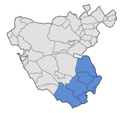
Campo de Gibraltar (Template:IPA-es, "Gibraltar Countryside") is a comarca (county) in the province of Cádiz, Spain, in the southwestern part of the autonomous community of Andalusia, the southernmost part of mainland Europe. It comprises the municipalities of Algeciras, La Línea de la Concepción, San Roque, Los Barrios, Castellar de la Frontera, Jimena de la Frontera and Tarifa.
Its name comes from the municipal term of the town of Gibraltar, now a British Overseas Territory. Until 1704, the Campo de Gibraltar was simply the term for the municipality of Gibraltar, about 500 km corresponding approximately to the current municipalities of Algeciras, San Roque, Los Barrios and La Línea de la Concepción. Following the capture of Gibraltar by Anglo-Dutch troops in 1704 during the War of the Spanish Succession and its subsequent cession, in 1713, to Great Britain, the former inhabitants of Gibraltar settled down permanently and the first villages were created: Algeciras, San Roque, and Los Barrios, still for many years officially termed the municipality of Gibraltar. In 1759, each of them was established as a different municipality.
The Campo de Gibraltar comarca is integrated by the following municipalities:
| Municipality | Area (km²) |
Population (2008) |
Location |
|---|---|---|---|
| Algeciras | 86 | 115,333 | Bay of Gibraltar |
| La Línea de la Concepción | 26 | 64,240 | Bay of Gibraltar Mediterranean coast |
| San Roque | 140 | 28,563 | Interior - Bay of Gibraltar Mediterranean coast |
| Los Barrios | 332 | 21,977 | Interior Los Alcornocales Natural Park Bay of Gibraltar |
| Castellar de la Frontera | 179 | 3,109 | Interior Los Alcornocales Natural Park |
| Jimena de la Frontera | 347 | 10,330 | Interior Los Alcornocales Natural Park |
| Tarifa | 419 | 17.793 | Atlantic coast Los Alcornocales Natural Park |
| Total | 1,529 | 261,345 |
References
- Manuel Álvarez Vázquez (April 2004). "La pérdida de Gibraltar y el nacimiento de la nueva población de Los Barrios" (PDF). Almoraima. Revista de Estudios Campogibraltareños (34): 51–66. Archived from the original (PDF) on 2009-02-20.
{{cite journal}}: Unknown parameter|deadurl=ignored (|url-status=suggested) (help)
External links
| Comarcas of Andalusia | |
|---|---|
| Almería | |
| Cádiz | |
| Córdoba | |
| Granada | |
| Huelva | |
| Jaén | |
| Málaga | |
| Sevilla | |
36°08′N 5°27′W / 36.133°N 5.450°W / 36.133; -5.450
This Spain location article is a stub. You can help Misplaced Pages by expanding it. |
This Gibraltar-related article is a stub. You can help Misplaced Pages by expanding it. |