| Abancay | |
|---|---|
| Province | |
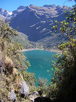
 Ampay (in the background on the left) as seen from Usphaqucha Ampay (in the background on the left) as seen from Usphaqucha | |
 Flag Flag Coat of arms Coat of arms | |
 Location of Abancay in the Apurímac Region Location of Abancay in the Apurímac Region | |
| Country | Peru |
| Region | Apurímac |
| Capital | Abancay |
| Government | |
| • Mayor | Guido Chahuaylla |
| Area | |
| • Total | 3,447.13 km (1,330.94 sq mi) |
| Population | |
| • Total | 110,520 |
| • Density | 32/km (83/sq mi) |
| UBIGEO | 0301 |
| Website | www |
Abancay is one of seven provinces of the Apurímac Region in Peru. The capital of the province is the city of Abancay.
Boundaries
- North: Cusco Region
- East: provinces of Cotabambas and Grau
- South: provinces of Aymaraes, Antabamba and Grau
- West: provinces of Andahuaylas and Aymaraes
Geography
One of the highest mountains of the province is Ampay located in the Ampay National Sanctuary. Other mountains are listed below:
- Allqa Marka
- Antaqucha
- Aqu Q'asa
- Atuq Pata
- Chakana
- Chaku Urqu
- Chawpi
- Chunkara
- Chuntani
- Hatun Ullukuyuq
- Huch'uy Q'urawiri
- Ichhu Urqu
- Inka Pirqa
- Inka Wasi
- Janq'u Marka
- Kallanka
- Kimsa P'ukru
- Kimsa P'unqu
- Kimsa Urqu
- Kimsaqucha
- Kimsa Wayna
- Kiska Urqu
- Kuntur Sinqa
- Kunturillu
- Lurituyuq
- Llaksa
- Llikawi
- Mawk'allaqta
- Muruqucha
- Pillpintu
- Pinqulluni
- Pirwata
- Pisqaqucha
- Pukara
- P'unqu Q'asa
- Qala Saywa
- Qillqas
- Qiñwa Marka
- Qiñwa Urqu
- Quncha Pallana
- Q'illu Q'asa
- Q'illu Q'asa (Aban.-Grau)
- Q'urawiri
- Rumi Chaka
- Runtuqucha
- Silla Urqu
- Suntur
- Sunturu
- Sunturuyuq
- Sunqun Marka
- Surimana
- Waman Ch'arpa
- Waraquyuq
- Warmi Rumi
- Wayllayuq
- Willkawara
- Wiraqucha
- Wisk'achayuq
- Yana Allpa
- Yana Qaqa
- Yana Urqu
Political division
The province of Abancay is divided into nine districts, which are:
| District | Mayor |
|---|---|
| Abancay | Guido Chahuaylla Maldonado |
| Chacoche | Martin Puma Cayllahua |
| Circa | Asunto Gregorio Montoya Juro |
| Curahuasi | Danilo Valenza Calvo |
| Huanipaca | Jose Chacon Vargas |
| Lambrama | Hilario Saldivar Taipe |
| Pichirhua | Marcelino Montes Aguilar |
| San Pedro de Cachora | Huber Cuaresma Espinoza |
| Tamburco | Fernando Zuñiga Gutierrez |
Ethnic groups
The province is inhabited by indigenous citizens of Quechua descent. Spanish is the language which the majority of the population (51.47%) learnt to speak in childhood, 48.06% of the residents started speaking using the Quechua language and 0.21% using Aymara (2007 Peru Census).
See also
References
- escale.minedu.gob.pe - UGEL map of the Abancay Province (Apurímac Region)
- inei.gob.pe Archived 2013-01-27 at the Wayback Machine INEI, Peru, Censos Nacionales 2007
| |
|---|---|
13°38′02″S 72°52′52″W / 13.634°S 72.881°W / -13.634; -72.881
This Apurímac Region geography article is a stub. You can help Misplaced Pages by expanding it. |