| This article includes a list of references, related reading, or external links, but its sources remain unclear because it lacks inline citations. Please help improve this article by introducing more precise citations. (January 2019) (Learn how and when to remove this message) |
| Native name: Isla Acuy | |
|---|---|
 | |
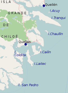
 South east of Chiloé Island: Quellón, Chaullín, Acuy, Tranqui, Coldita, Cailin, Laitec, Queilén South east of Chiloé Island: Quellón, Chaullín, Acuy, Tranqui, Coldita, Cailin, Laitec, Queilén | |
| Geography | |
| Coordinates | 42°55′17″S 73°25′41″W / 42.921411°S 73.428151°W / -42.921411; -73.428151 |
| Length | 2 km (1.2 mi) |
| Width | 0.5 km (0.31 mi) |
| Administration | |
| Chile | |
| Region | Los Ríos |
| Province | Chiloé Province |
| Commune | Queilén |
| Demographics | |
| Population | 135 |
| Additional information | |
| NGA UFI=-871214 | |
Acuy is a small island southeast of the town of Queilén. It is about 2 km long and 500 m wide at its largest points, and therefore has only a small population.
The population is mainly devoted to fishing and gathering luga.
See also
References
External links
- Islands of Chile @ United Nations Environment Programme Archived 2013-05-01 at the Wayback Machine
- World island information @ WorldIslandInfo.com
- South America Island High Points above 1000 meters
- United States Hydrographic Office, South America Pilot (1916)
- Geography