Municipality in Ontario, Canada
| Gordon/Barrie Island | |
|---|---|
| Municipality (single-tier) | |
| Municipality of Gordon/Barrie Island | |
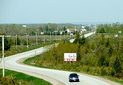
 Highway 540 through Gordon Highway 540 through Gordon | |
  | |
| Coordinates: 45°54′N 82°38′W / 45.900°N 82.633°W / 45.900; -82.633 | |
| Country | Canada |
| Province | Ontario |
| District | Manitoulin |
| Formed | January 1, 2009 |
| Government | |
| • Type | Township |
| • Reeve | Lee Hayden |
| • Federal riding | Algoma—Manitoulin—Kapuskasing |
| • Prov. riding | Algoma—Manitoulin |
| Area | |
| • Land | 267.77 km (103.39 sq mi) |
| Population | |
| • Total | 490 |
| • Density | 1.8/km (5/sq mi) |
| Time zone | UTC-5 (EST) |
| • Summer (DST) | UTC-4 (EDT) |
| Postal Code | P0P |
| Area code | 705 |
| Website | gordonbarrieisland |
The Municipality of Gordon/Barrie Island is a township in Manitoulin District in north central Ontario, Canada. It was formed on January 1, 2009, upon the amalgamation of the townships of Gordon and Barrie Island.
The township consists of the communities of Advance, Foxey, Ice Lake, Tobacco Lake and Barrie Island. Gordon/Barrie Island also contains three lakes: Nameless Lake, Tobacco Lake and Ice Lake.
Barrie Island
Barrie Island (45°55′N 82°40′W / 45.917°N 82.667°W / 45.917; -82.667) is about 8 kilometres (5.0 mi) wide, 13 kilometres (8.1 mi) long, and has a surface area of 79 square kilometres (31 sq mi). It is connected to Manitoulin by Highway 540A, which crosses the water via a causeway at the narrowest part of the strait.
The island has a significant summer recreational population.
John Gordon Lane was born on Barrie Island, the Member of Provincial Parliament for Algoma—Manitoulin from 1971 to 1987.

Demographics
In the 2021 Census of Population conducted by Statistics Canada, Gordon/Barrie Island had a population of 613 living in 294 of its 621 total private dwellings, a change of 25.1% from its 2016 population of 490. With a land area of 263.44 km (101.71 sq mi), it had a population density of 2.3/km (6.0/sq mi) in 2021.
Canada census – Gordon/Barrie Island community profile| 2021 | 2016 | 2011 | |
|---|---|---|---|
| Population | 613 (+25.1% from 2016) | 490 (-6.8% from 2011) | 526 (+14.6% from 2006) |
| Land area | 263.44 km (101.71 sq mi) | 267.77 km (103.39 sq mi) | 268.14 km (103.53 sq mi) |
| Population density | 2.3/km (6.0/sq mi) | 1.8/km (4.7/sq mi) | 2.0/km (5.2/sq mi) |
| Median age | 61.6 (M: 62.8, F: 60.0) | 51.4 (M: 52.4, F: 50.4) | |
| Private dwellings | 621 (total) 294 (occupied) | 523 (total) | 599 (total) |
| Median household income | $68,500 | $56,960 |
Population trend:
- Population in 2011: 526
- Gordon Township: 491
- Barrie Island Township: 35
- Population in 2006:
- Gordon Township: 412
- Barrie Island Township: 47
- Population in 2001:
- Gordon Township: 473
- Barrie Island Township: 50
- Population in 1996:
- Gordon Township: 470 (adjusted for 2001 boundaries)
- Barrie Island Township: 60
- Population in 1991:
- Barrie Island Township: 75
See also
References
- ^ "Census Profile, 2016 Census: Gordon/Barrie Island, Municipality". Statistics Canada. 8 February 2017. Retrieved June 20, 2019.
- "Annual changes to census subdivision codes, names and types, between 2006 and 2011, by province and territory, and by year". Standard Geographical Classification (SGC) 2011. Statistics Canada. Retrieved 2012-02-22.
- "Population and dwelling counts: Canada, provinces and territories, census divisions and census subdivisions (municipalities), Ontario". Statistics Canada. February 9, 2022. Retrieved March 31, 2022.
- "2021 Community Profiles". 2021 Canadian census. Statistics Canada. February 4, 2022. Retrieved 2023-10-19.
- "2016 Community Profiles". 2016 Canadian census. Statistics Canada. August 12, 2021. Retrieved 2019-06-20.
- "2011 Community Profiles". 2011 Canadian census. Statistics Canada. March 21, 2019. Retrieved 2012-02-22.
- Statistics Canada: 2001, 2006, 2011 census
External links
| Places adjacent to Gordon/Barrie Island | ||||||||||||||||
|---|---|---|---|---|---|---|---|---|---|---|---|---|---|---|---|---|
| ||||||||||||||||
| Manitoulin District, Ontario | |
|---|---|
| Towns | |
| Townships | |
| First Nations | |
| Indian reserves | |
| Unorganized terrtories | |
| Local services boards | |