| Albert Gallatin Memorial Bridge | |
|---|---|
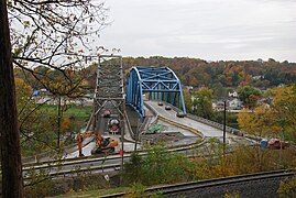
 1930 bridge (left) the day after its closing, with its replacement on the right. 1930 bridge (left) the day after its closing, with its replacement on the right. | |
| Coordinates | 39°44′21″N 79°54′12″W / 39.73917°N 79.90333°W / 39.73917; -79.90333 |
| Carries | |
| Crosses | Monongahela River |
| Named for | Albert Gallatin |
| Maintained by | PennDOT |
| Characteristics | |
| Total length | 810 ft (250 m) |
| Width | 28 ft (8.5 m) |
| History | |
| Constructed by | Point Marion Bridge Company |
| Marion Bridge | |
| U.S. National Register of Historic Places | |
 Side of the bridge Side of the bridge | |
| Location | Pennsylvania Route 88 over the Monongahela River, Point Marion, Pennsylvania |
| Area | less than one acre |
| Built | 1930 |
| Architectural style | Cantilever through truss |
| MPS | Highway Bridges Owned by the Commonwealth of Pennsylvania, Department of Transportation TR |
| NRHP reference No. | 88000841 |
| Added to NRHP | June 22, 1988 |
| Location | |
The Albert Gallatin Memorial Bridge (also known as the Point Marion Bridge) was a cantilever truss bridge that carried vehicular traffic across the Monongahela River in the southwestern part of the U.S. state of Pennsylvania. Built in 1930 to replace a ferry, it connected Point Marion in Fayette County and Dunkard Township in Greene County. It was named in honor of U.S. Senator, and longtime U.S. Treasury Secretary and diplomat Albert Gallatin, whose Friendship Hill homestead is nearby.
History
The original bridge was constructed in 1930 by the Point Marion Bridge Company and rehabilitated in 1976.
It was a historically significant bridge due to the relatively unusual cantilever truss design and was listed on the National Register of Historic Places as the second oldest bridge of this type in the state.
It was replaced by the new Point Marion Bridge in October 2009. The old bridge was imploded on November 16, 2009.
Photo gallery
-
 West end of the 1930 bridge.
-
 East end of the 1930 bridge.
-
 West end of the 1930 and 2009 bridges.
-
 The new bridge standing alone in 2010.
See also
References
- "National Register Information System". National Register of Historic Places. National Park Service. March 13, 2009.
- ^ Jon Schmitz (October 23, 2009). "Officials dedicate new bridge - Parker truss span replaces structure labeled worst in the state". Pittsburgh Post-Gazette. Retrieved March 21, 2010.
- "Point Marion Bridge Interpretive Panel" (PDF). Cultural Heritage Research Services. Archived from the original (PDF) on July 8, 2011. Retrieved March 22, 2010.
- "Point Marion Bridge - Albert Gallatin Memorial Bridge". 2009. Archived from the original on November 23, 2010. Retrieved March 22, 2010.
- "Canary Systems - Project Profile – Bridge Abutment Construction Monitoring" (PDF). Spring 2009. Retrieved March 22, 2010.
- "Old bridge at Point Marion brought down in controlled implosion". Pittsburgh Post-Gazette. November 16, 2009. Retrieved March 22, 2010.
External links
[REDACTED] Media related to Albert Gallatin Memorial Bridge at Wikimedia Commons
| Bridges and Dams of the Monongahela River | ||||
|---|---|---|---|---|
| ||||
- Bridges completed in 1930
- Bridges over the Monongahela River
- Road bridges on the National Register of Historic Places in Pennsylvania
- Bridges in Fayette County, Pennsylvania
- Bridges in Greene County, Pennsylvania
- National Register of Historic Places in Greene County, Pennsylvania
- Steel bridges in the United States
- Cantilever bridges in the United States
- Parker truss bridges in the United States

