| Alibey | |
|---|---|
| Neighbourhood | |
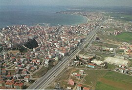
 Alibey neighborhood in the left bottom corner of the aerial image of Silivri Alibey neighborhood in the left bottom corner of the aerial image of Silivri | |
  | |
| Coordinates: 41°04′22″N 28°15′16″E / 41.07278°N 28.25444°E / 41.07278; 28.25444 | |
| Country | Turkey |
| Province | Istanbul |
| District | Silivri |
| Population | 18,072 |
| Time zone | UTC+3 (TRT) |
| Postal code | 34570 |
| Area code | 0212 |


Alibey is a neighbourhood in the municipality and district of Silivri, Istanbul Province, Turkey. Its population is 18,072 (2022). It is situated southeast of the city center, bordered by the highway D-100 in the north.
The neighborhood takes its name from a no more existing Alibey Mosque. The historic mosque in Silivri was destroyed by the invading Bulgarian troops of the Principality of Bulgaria during the Russo-Turkish War (1877–1878).
Public buildings and places in Alibey are: the Silivri Municipality central service buildings (Turgut Özal Blvd.), the courthouse (Turgut Özal Blvd.), the headquarters of Silivri district Gendarmerie (Çetin St.), and the Silvri Cemetery (Akgün Silivri St.).
Population
| Year | Pop. | ±% p.a. |
|---|---|---|
| 2007 | 15,626 | — |
| 2012 | 17,404 | +2.18% |
| 2017 | 18,122 | +0.81% |
| 2022 | 18,072 | −0.06% |
| Source: TÜIK (2007-2022) | ||
Education
Six schools are located in Alibey, which are:
- Public schools
- Piri Mehmet Paşa İlkokulu (Primary school)
- Gazi İmam Hatip Ortaokulu (Secondary İmam Hatip school)
- Silivri Ortaokulu (Secondary school)
- Silivri Anadolu Lisesi (Anatolian High School)
- Private schools
- Özel Mektebim Koleji Silivri Fen Lisesi (Science high school)
- Özel Silivri Sınav Koleji Anadolu Lisesi (Anatolian High School)
Sport
The women's football club Alibeyspor competes in the Turkish Women's Third League.
Health care
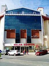
The private hospital Silivri Özel Kolan Hastanesi (Turgut Özal Blvd.) is situated in ALibey.
References
- Mahalle, Turkey Civil Administration Departments Inventory. Retrieved 12 July 2023.
- ^ "Population Of Municipalities, Villages And Quarters". TÜIK. Retrieved 24 March 2023.
- "Silivri Ali Bey Camii" (in Turkish). İstanbul Çevre Kültür ve Tarihi Eserleri KorumaDerneği. Retrieved 4 October 2020.
- "İletişim" (in Turkish). Silivri Belediyesi. Retrieved 5 October 2020.
- "Silivriİ Adalet Sarayı Ulaşım ve Telefon İşletim Bilgileri" (in Turkish). Silivri Adliyesi. Retrieved 5 October 2020.
- "Silivri Jandarma Komutanlığı" (in Turkish). Bulurum. Retrieved 5 October 2020.
- Silivri Asri Mezarlığı (Map). Maps. Retrieved 5 October 2020.
- "Silivri - Alibey Okulları" (in Turkish). Okul. Retrieved 4 October 2020.
- "Alibeyspor" (in Turkish). Türkiye Futbol Federasyonu. Retrieved 4 October 2020.
- "Kadın Futbolu Ligleri » Arşiv » Kadınlar 3. Ligi 2019 - 2020 Sezonu" (in Turkish). Türkiye Futbol Federasyonu. Retrieved 4 October 2020.
- "<Silivri Özel Kolan Hastanesi" (in Turkish). Sağlık. Retrieved 4 October 2020.
| Neighbourhoods of Silivri District | |
|---|---|
|