| パナリ | |
|---|---|
 | |
| Geography | |
| Coordinates | 24°13′05″N 123°55′53″E / 24.21806°N 123.93139°E / 24.21806; 123.93139 |
| Archipelago | Ryukyu Islands |
| Administration | |
| Japan | |
| Okinawa Prefecture | |
| Taketomi | |
| Demographics | |
| Population | 15 |
| Ethnic groups | Ryukyuan, Japanese |
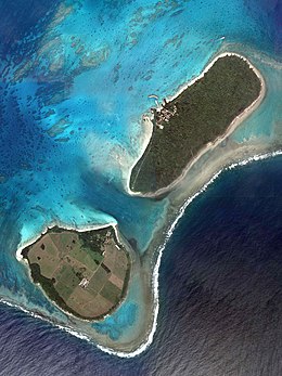
The Aragusuku Islands (Japanese: 新城島, Aragusuku-jima, Yaeyama: パナリ, Panari) consist of two smaller islets, named Kamiji and Shimoji. They are located in the Yaeyama Islands of Okinawa Prefecture, Japan.
Aragusuku has a population of 15, all of them living on Kamiji. Shimoji is used as a pasture for cattle. Aragusuku is administered by the town of Taketomi on nearby Iriomote. The island can be accessed via tours.
History
The Aragusuku Islands used to be a part of the Ryukyu Kingdom until 1879. During the Ryukyuan era, the islands had as many as 700 people. After World War II, the islands were administered by the United States Civil Administration of the Ryukyu Islands before being returned to Japan in 1972, along with the rest of Okinawa.
Culture
The Aragusuku Islands, like Hamahiga, is known for its preservation of traditional lifestyles. Among locals, the island is referred to as "パナリ (Panari)", meaning "separated" in the Aragusuku dialect of the Yaeyama language.
See also
References
- ^ "Aragusuku Island". VISIT OKINAWA JAPAN. Retrieved 2020-10-16.
- "ARAGUSUKU island | HIRATA TOURISM" (in Japanese). Retrieved 2020-10-16.
- ^ "Tips for Kuroshima & Aragusuku (Panari) of the Yaeyama Islands, Okinawa". Islands of Japan - Travel Tips by Ippei and Janine. Retrieved 2020-10-16.
- "The History of Okinawa". VISIT OKINAWA JAPAN. Retrieved 2020-10-16.
This Okinawa Prefecture location article is a stub. You can help Misplaced Pages by expanding it. |