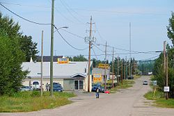
Place in Ontario, Canada
| Armstrong | |
|---|---|
| compact rural community unincorporated place | |
 | |
 | |
| Coordinates: 50°18′18″N 89°02′31″W / 50.30500°N 89.04194°W / 50.30500; -89.04194 | |
| Country | Canada |
| Province | Ontario |
| District | Thunder Bay |
| Time zone | UTC-5 (Eastern Time Zone) |
| • Summer (DST) | UTC-4 (Eastern Time Zone) |
| Postal Code | P0T 1A0 |
| Area code | 807 |
Armstrong is a compact rural community, unincorporated place, and divisional point on the Canadian National Railway transcontinental railway main line in the unorganized portion of Thunder Bay District in Northwestern Ontario, Canada. The Whitesand First Nation's Armstrong Settlement is coterminous to this community. The Armstrong area is a popular tourist destination in the summer for fishing and hunting.

The community is not part of an incorporated municipality, but is administered by a local services board.
Canadian Forces Station Armstrong, located 1.1 miles (1.8 km) east of Armstrong, was closed in 1974. Later that year the base was sold to private owners and turned into a popular gathering area for the town that included a restaurant and bar, hotel, multiple apartments, garages, and a curling rink. The area, known as D&L, was closed and abandoned in 1993 and remains that way today.
The town of Armstrong currently has a public school, two restaurants, a Canada Post post office, a clinic, a Mini Mart gas station and motel, and the Armstrong General store (formally J&J General store 1961–2015).
Demographics
In the 2021 Census of Population conducted by Statistics Canada, Armstrong had a population of 146 living in 60 of its 208 total private dwellings, a change of -24.4% from its 2016 population of 193. With a land area of 323.85 km (125.04 sq mi), it had a population density of 0.5/km (1.2/sq mi) in 2021.
According to the Canada 2016 Census, the community had a population of 193, down from 220 in 2011, a decrease of 12.3%. There are 186 dwellings of which 84 are occupied by usual residents.
Transportation
Armstrong is accessible via Highway 527, which extends 235 kilometres (146 mi) north from Highway 11/17 near Thunder Bay. It takes about three hours to get to Armstrong by car from Thunder Bay.
Armstrong Airport is located 4.5 nautical miles (8.3 kilometres; 5.2 miles) east southeast of Armstrong.
The Via Rail Canadian train travels through and stops on request in Armstrong.
| Preceding station | Following station | |||
|---|---|---|---|---|
| Collinstoward Vancouver | The Canadian | Mud Rivertoward Toronto | ||
| Former services | ||||
| Preceding station | Canadian National Railway | Following station | ||
| Onapingtoward Vancouver | Main Line | Wagamingtoward Montreal | ||
References
- ^ "Armstrong". Geographical Names Data Base. Natural Resources Canada. Retrieved 2014-03-24.
- "Local Services Boards - Armstrong". Northern Services Boards Act / Loi sur les régies des services publics du nord - R.R.O. 1990, Regulation 737. Canadian Legal Information Institute. 2009-11-04. Archived from the original on 2014-03-10. Retrieved 2009-11-10.
- "Population and dwelling counts: Canada and designated places". Statistics Canada. February 9, 2022. Retrieved Jan 10, 2025.
- "Census Profile, 2016 Census - Armstrong, Local service board [Designated place], Ontario and Ontario [Province]". 8 February 2017.
- "The Canadian westbound schedule" (PDF). Via Rail. Retrieved 2014-03-24.
This Northern Ontario geographical article is a stub. You can help Misplaced Pages by expanding it. |
