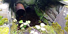

Aughatubbrid (Irish: Achadh Tiobraide), also known as Chatsworth, is a townland in County Kilkenny, Ireland. The townland, which has an area of approximately 6.63 square kilometres (2.56 sq mi), is in the civil parish of Castlecomer. The village and townland of Clogh is to the east. As of the 2011 census, Aughatubbrid had a population of 331 people.
The existence of wells in Aughatubbrid is referenced in the townland's Irish name, which translates to "field of the well" or "field of the spring". The name can be traced back to 1594 as Aghetobbir. One such well, known as "Church Well", was previously considered to be a holy well, and patterns were held there annually in September until at least 2016. The holy well site is recorded in the Record of Monuments and Places (RMP) with number "KK002-001003-". Church Well takes its name from a former church in the area. The site of this former church lies 80m northwest of the holy well and has RMP number "KK002-001001-".
References
- "Achadh Tiobraide / Aughatubbrid or Chatsworth". logainm.ie. Placenames Database of Ireland. Retrieved 2 August 2024.
- ^ "Aughatubbrid or Chatsworth Townland, Co. Kilkenny". townlands.ie. Retrieved 2 August 2024.
- "CD158 - Kilkenny Population by Private Households, Occupied and Vacancy Rate". data.gov.ie. Central Statistics Office. Retrieved 2 August 2024.
Population Townlands Aughatubbrid or Chatsworth, Clogh, Co. Kilkenny: 331
- Carrigan, William (1905). The History and Antiquities of the Diocese of Ossory, vol. II. p. 190.
About 100 yards south of the church site is the fine spring, now called the Church Well, from which the townland of Aghatubrid derived its name. It is a holy well, and pilgrimages and patterns were formerly held here.
- ^ O'Kelly, Owen (1985). The Place-Names of County Kilkenny (PDF). Kilkenny: Kilkenny Archaeological Society. p. 33.
Aughatubrid (now Chatsworth) Achadh tiobraide, field of the spring The ancient church was in the Church Hill field and Carrigan in his Notes states that the Tiobraid beside the church was a holy well; also that there was another holy well called Bruach dearg
- ^ Ó Dálaigh, Pádraig (2018), The Holy Wells of County Kilkenny in terms of documentary coverage, location, ritual practice and onomastic concept, vol. II, Limerick, pp. 319, 360
{{citation}}: CS1 maint: location missing publisher (link) - "Historic Environment Viewer - KK002-001003-". National Monuments Service. Retrieved 16 June 2024.
- "Historic Environment Viewer - KK002-001001-". National Monuments Service. Retrieved 22 July 2024.
KK002-001001- : Church There is a holy well (KK002-001003-) 80m to the SW with modern capping
52°52′N 7°10′W / 52.867°N 7.167°W / 52.867; -7.167
Category: