| This article needs additional citations for verification. Please help improve this article by adding citations to reliable sources. Unsourced material may be challenged and removed. Find sources: "Bahia Portete" La Guajira, Colombia – news · newspapers · books · scholar · JSTOR (December 2021) (Learn how and when to remove this message) |
| Bahía de Portete | |
|---|---|
 | |
 | |
| Location | La Guajira, Colombia |
| Coordinates | 12°11.515′N 71°55.25′W / 12.191917°N 71.92083°W / 12.191917; -71.92083 |
| Ocean/sea sources | Caribbean Sea |
| Basin countries | Colombia |
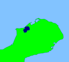
Bahía de Portete (Bahia Portete) is a bay in La Guajira, Colombia. It lies approximately 30 miles (48 km) from the Venezuelan border on the Guajira Peninsula in the northeast region of Colombia. The bay opens to the Caribbean Sea. A large coal terminal lies at the mouth of the bay, and the bay's inlet is less than 1 mile (2 km) wide.
The Puerto Bolivar Airport is the closest airport to the bay.
References
- "DISEÑO DE UN ÁREA MARINA PROTEGIDA PARA BAHÍA PORTETE - LA GUAJIRA, CARIBE COLOMBIANO". Boletín de Investigaciones Marinas y Costeras - INVEMAR.
This Colombian location article is a stub. You can help Misplaced Pages by expanding it. |