| This article relies largely or entirely on a single source. Relevant discussion may be found on the talk page. Please help improve this article by introducing citations to additional sources. Find sources: "Bandaraya LRT station" – news · newspapers · books · scholar · JSTOR (November 2024) |
| AG6 SP6 Bandaraya | |||||||||||||||
|---|---|---|---|---|---|---|---|---|---|---|---|---|---|---|---|
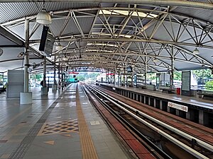
 Platform view of the station at daytime Platform view of the station at daytime | |||||||||||||||
| General information | |||||||||||||||
| Location | Jalan Raja Laut 50350 WP Kuala Lumpur | ||||||||||||||
| Coordinates | 3°9′20″N 101°41′39″E / 3.15556°N 101.69417°E / 3.15556; 101.69417 | ||||||||||||||
| Owned by | Prasarana Malaysia | ||||||||||||||
| Operated by | Rapid Rail | ||||||||||||||
| Line(s) | 3 Ampang 4 Sri Petaling | ||||||||||||||
| Platforms | 2 side platforms | ||||||||||||||
| Tracks | 2 | ||||||||||||||
| Connections | Connecting station to KA03 Bank Negara via a 140 meters walking distance. | ||||||||||||||
| Construction | |||||||||||||||
| Structure type | Elevated | ||||||||||||||
| Platform levels | 2 | ||||||||||||||
| Parking | Not available | ||||||||||||||
| Other information | |||||||||||||||
| Station code | AG6 SP6 | ||||||||||||||
| History | |||||||||||||||
| Opened | 16 December 1996 | ||||||||||||||
| Services | |||||||||||||||
| |||||||||||||||
Bandaraya LRT station is an elevated rapid transit station in central Kuala Lumpur, Malaysia. The station is on the common route shared by the Ampang Line and Sri Petaling Line (originally known as STAR Line). The station opened on 16 December 1996, as part of the first phase of the STAR system's opening, along with 13 adjoining stations along the Sultan Ismail to Ampang route.
Description

The station stands between the eastern banks of the Gombak River and an intersection between Jalan Raja Laut, a major thoroughfare along the Gombak River, and Jalan Isfahan. Bandaraya is the southernmost LRT station along the Gombak River. The station is also within close proximity of several shopping complexes, the present Kuala Lumpur City Hall building, the Bank Negara headquarters, and Little India Precinct.
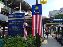
The station is some 140 m from the KA03 Bank Negara station, a KTM Komuter station, to which it is linked by a footbridge. It was the first station on the line to have an interchange with another railway system and, prior to the opening of Kelana Jaya Line and remaining phases of the STAR lines, the only station of this kind, although there was no network integration in terms of fares or ticketing. Bandaraya is also close to bus stops along Jalan Raja Laut, Jalan Dang Wangi and Jalan Tuanku Abdul Rahman.
Around the station
- SOGO KL
- Pertama Complex
- CapSquare Centre
- City One Plaza
- Jalan Tuanku Abdul Rahman
- CIMB Bank
- United Overseas Bank
- Coliseum Theatre
- DBKL headquarters – the namesake of the station
Gallery
-
Exterior view from the SOGO link bridge.
-
Bandaraya LRT station
-
 A platform view of the Bandaraya station.
-
 An exterior view of the Bandaraya station, facing southwest.
-
Another exterior view of the Bandaraya station, facing northwest.
-
 View of entire station from SOGO department store.
-
 View of concourse of the station.
-
 LRT Bandaraya bus lay-by
-
 LRT10 Shuttle Bus
See also
References
- "Bandaraya LRT Station | mrt.com.my". mrt.com.my. Retrieved 8 November 2024.