| Baragkhan Барагхан | |
|---|---|
| Settlement | |
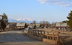
 Street in Baragkhan Street in Baragkhan | |
  | |
| Coordinates: 54°8′58″N 110°9′41″E / 54.14944°N 110.16139°E / 54.14944; 110.16139 | |
| Country | Russia |
| Region | Republic of Buryatia |
| District | Kurumkansky District |
| Time zone | UTC+8:00 |
Baragkhan (Russian: Барагхан; Buryat: Бархан, Barkhan) is a rural locality (a selo) in Kurumkansky District of the Republic of Buryatia, Russia. Population: 1,098 (2010 Census); 1,144 (2002 Census);
References
- Карта Курумканского района Бурятии
- Russian Federal State Statistics Service (2011). Всероссийская перепись населения 2010 года. Том 1 [2010 All-Russian Population Census, vol. 1]. Всероссийская перепись населения 2010 года (in Russian). Federal State Statistics Service.
- Federal State Statistics Service (21 May 2004). Численность населения России, субъектов Российской Федерации в составе федеральных округов, районов, городских поселений, сельских населённых пунктов – районных центров и сельских населённых пунктов с населением 3 тысячи и более человек [Population of Russia, Its Federal Districts, Federal Subjects, Districts, Urban Localities, Rural Localities—Administrative Centers, and Rural Localities with Population of Over 3,000] (XLS). Всероссийская перепись населения 2002 года (in Russian).
| Rural localities in Kurumkansky District | ||
|---|---|---|
This Buryatia location article is a stub. You can help Misplaced Pages by expanding it. |