| This article does not cite any sources. Please help improve this article by adding citations to reliable sources. Unsourced material may be challenged and removed. Find sources: "Bhaba Valley" – news · newspapers · books · scholar · JSTOR (September 2021) (Learn how and when to remove this message) |
| Bhaba Valley | |
|---|---|
 | |
| Floor elevation | 2,200–6,000 m (7,200–19,700 ft) |
| Geography | |
| State/Province | Himachal Pradesh |
| District | Kinnaur |
| Borders on | |
| Mountain range | Himalaya & Zanskar Range |
| River | Wangyur River |
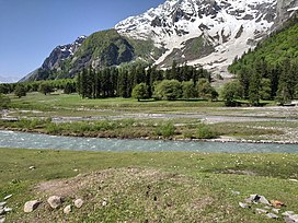
The Bhaba Valley (also known as Wangpo in the local Kinnauri language) is a valley in the northern Indian state of Himachal Pradesh. It is formed by the Wangyur river in the district of Kinnaur, which originates near Bhaba Pass. The Wangtu bridge is the gateway to the valley. There are 17 villages within the valley. These villages are in turn divided into five Panchayats: Katgaon, Yangpa 1, Yangpa 2, Kraba and Kafnu. Most of the valley's inhabitation is in Katgaon village.
The Bhaba Pass connects the Bhaba Valley on the Kinnaur side with the Pin valley on the Spiti side.
Gallery
References
External links
- Bhabha Valley
- Bhaba Valley Trek, Kinnaur
- Pin Bhaba Pass-A high-altitude crossover trek in Himachal Pradesh
This Himachal Pradesh location article is a stub. You can help Misplaced Pages by expanding it. |
