| Native name: Te Nihokiore, Timata | |
|---|---|
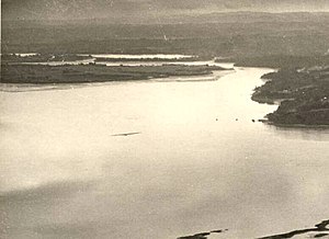
 Boat Rock in the central Waitematā Harbour, pictured in 1946 Boat Rock in the central Waitematā Harbour, pictured in 1946 | |
| Geography | |
| Location | Auckland |
| Coordinates | 36°49′47″S 174°41′36″E / 36.829855°S 174.693281°E / -36.829855; 174.693281 |
| Adjacent to | Waitemata Harbour |
| Administration | |
| New Zealand | |
Boat Rock is a tiny sandstone island in the Waitematā Harbour of Auckland, New Zealand. Boat Rock is a vanishing island, which is submerged at high tide.
Geology
The rock is a piece of Waitemata Group sandstone exposed in the Waitematā Harbour. The rock is an intertidal reef, exposed during low tide. The surface of Boat Rock is covered in sand and shell deposits.
Boat Rock is home to a number of species including sea slugs such as Dendrodoris citrina, Dendrodoris nigra and Pleurobranchaea maculata, sea snails such as Maoricolpus roseus and Dicathais orbita. In addition, the island is home to kina and a species of chiton, Cryptoconchus porosus.
History
The island was traditionally referred to by Tāmaki Māori iwi by various names, including Te Nihokiore ("The Rat's Tooth"), Timata, Te-Toka-tu-Moana ("The Rock Standing in Mid-Sea"), Te-Waka-o-Tawaroa and Te Mata-o-Kahu. Te Nihokiore is likely a metaphor for how the rocks remain sharp despite being battered by the sea, similar to a rat's tooth. The island is the namesake of the Waitematā Harbour, which literally means "Waters of Te Mata". The name refers to Te Arawa chief Kahumatamomoe, who when visiting the harbour placed a mauri stone (a stone of religious significance) on Boat Rock. The name Waitematā originally only referred to the upper harbour area near Boat Rock. Boat Rock was traditionally used as a rohe marker, designating the boundary of influence between different Tāmaki Māori iwi.
The waters surrounding Boat Rock were a traditional fishery, known by the name Waipokanoa ("The Waters of Foolishness").
In 1873, an iron ship beacon was erected on the island, which was damaged by ships in 1905.
References
- Hicks, SR; Kibblewhite, AC (1976). "Seismic reflection profiling in very Shallow waters in the upper Waitemata Harbour, New Zealand". New Zealand Journal of Geology and Geophysics. 19 (2): 213–231. Bibcode:1976NZJGG..19..213H. doi:10.1080/00288306.1976.10423518. ISSN 0028-8306.
- ^ Hayward, Bruce W.; Morley, Margaret S.; Stephenson, A. Brett; et al. (January 1999), Intertidal and Subtidal Biota and Habitats of the Central Waitemata Harbour, Auckland Regional Council, Wikidata Q123699062
- "Boat Rock". New Zealand Gazetteer. Land Information New Zealand. Retrieved 17 May 2022.
- ^ ""Waitemata." Meaning and History. A Popular Error". Auckland Star. Vol. LXII, no. 282. 28 November 1931. p. 12. Retrieved 17 May 2022 – via Papers Past.
- ^ Wilson, Karen (28 August 2018). "Brief of Evidence of Karen Akamira Wilson on Behalf of Te Ākitai Waiohua" (PDF). Ministry of Justice. Archived from the original (PDF) on 27 January 2019. Retrieved 17 May 2022.
- Graham, George (1951). "Tainui". The Journal of the Polynesian Society. 60 (1): 80–92. ISSN 0032-4000.
- ^ Simmons, D. R. (1979). "George Graham's Maori Place Names of Auckland". Records of the Auckland Institute and Museum. 16: 11–39. ISSN 0067-0464. JSTOR 42906272. Wikidata Q58677091.
- "Notice to Mariners". Wellington Independent. Vol. XXVIII, no. 3820. 2 June 1873. p. 2. Retrieved 17 May 2022 – via Papers Past.
- "Untitled". The New Zealand Herald. Vol. XLII, no. 12920. 17 July 1905. p. 6. Retrieved 17 May 2022 – via Papers Past.
| Kaipātiki Local Board Area, Auckland, New Zealand | |
|---|---|
| Populated places | |
| Geographic features | |
| Facilities and attractions | |
| Government | |
| Organisations | |