| Bogue Falaya | |
|---|---|
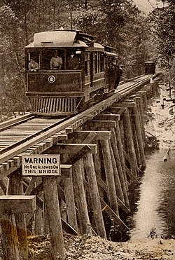
 Wooden bridge crossing the Bogue Falaya River near Covington, Louisiana, 1910s. Wooden bridge crossing the Bogue Falaya River near Covington, Louisiana, 1910s. | |
| Bogue Falaya | |
| Location | |
| Country | United States |
| State | Louisiana |
| Parishes | |
| Physical characteristics | |
| Source | |
| • location | Washington Parish, Louisiana |
| • coordinates | 30°42′11″N 90°09′55″W / 30.70306°N 90.16528°W / 30.70306; -90.16528 |
| Mouth | Tchefuncte River |
| • location | Covington, St. Tammany Parish, Louisiana |
| • coordinates | 30°26′23″N 90°06′59″W / 30.43972°N 90.11639°W / 30.43972; -90.11639 |
| Length | 28 mi (45 km) |
| Basin features | |
| Cities | Covington |
| Tributaries | |
| • left | Abita River |
The Bogue Falaya, also known as the Bogue Falaya River, is a 28-mile-long (45 km) river in southeastern Louisiana in the United States. It is a tributary of the Tchefuncte River, which flows to Lake Pontchartrain. The river flows through an area of mixed pine-hardwood and bottomland hardwood forests on the Gulf Coastal Plain.
The Bogue Falaya rises in southwestern Washington Parish and flows generally south-southeastwardly through western St. Tammany Parish, past Covington, where it collects the Abita River. It joins the Tchefuncte River about 10 miles (16 km) upstream of that river's mouth at Lake Pontchartrain.
The name is derived from the Choctaw words bogu, “river,” and falaya, "long."
A portion of the Bogue Falaya in St. Tammany Parish has been designated a "Natural and Scenic River" by the state government of Louisiana.
Variant names and spellings
According to the Geographic Names Information System, the Bogue Falaya has also been known historically as:
|
|
See also
References
- U.S. Geological Survey. National Hydrography Dataset high-resolution flowline data. The National Map Archived 2012-03-29 at the Wayback Machine, accessed June 20, 2011
- ^ Columbia Gazetteer of North America entry Archived August 25, 2005, at the Wayback Machine
- ^ Louisiana Department of Environmental Quality (2002). State of Louisiana Water Quality Management Plan Archived 2006-10-09 at the Wayback Machine: Appendix B: Descriptions of Louisiana's Natural and Scenic Rivers (PDF)
- DeLorme (2003). Louisiana Atlas & Gazetteer. Yarmouth, Maine: DeLorme. ISBN 0-89933-286-2
- Bushnell, D.I. (1909). The Choctaw of Bayou Lacomb, St. Tammany Parish, Louisiana. Washington: Government Printing Office. p. 7. No copyright in the United States.
- Leeper, Clare D'Artois (19 October 2012). Louisiana Place Names: Popular, Unusual, and Forgotten Stories of Towns, Cities, Plantations, Bayous, and Even Some Cemeteries. LSU Press. p. 42. ISBN 978-0-8071-4740-5.
- U.S. Geological Survey Geographic Names Information System: Bogue Falaya