| Bohostice | |
|---|---|
| Municipality | |
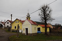
 Centre of Bohostice Centre of Bohostice | |
 Flag Flag Coat of arms Coat of arms | |
 | |
| Coordinates: 49°36′8″N 14°8′17″E / 49.60222°N 14.13806°E / 49.60222; 14.13806 | |
| Country | |
| Region | Central Bohemian |
| District | Příbram |
| First mentioned | 1386 |
| Area | |
| • Total | 20.90 km (8.07 sq mi) |
| Elevation | 417 m (1,368 ft) |
| Population | |
| • Total | 208 |
| • Density | 10.0/km (26/sq mi) |
| Time zone | UTC+1 (CET) |
| • Summer (DST) | UTC+2 (CEST) |
| Postal code | 262 31 |
| Website | www |
Bohostice is a municipality and village in Příbram District in the Central Bohemian Region of the Czech Republic. It has about 200 inhabitants.
Administrative division
Bohostice consists of two municipal parts (in brackets population according to the 2021 census):
- Bohostice (195)
- Kamenná (14)
Etymology
The origin of the name is unsure. The initial name of the village was probably Bohumstice and was derived from the personal Bohumest, meaning "the village of Bohumest's people".
Geography
Bohostice is located about 13 kilometres (8 mi) southeast of Příbram and 49 km (30 mi) south of Prague. It lies in the Benešov Uplands. The highest point is the hill Hřebeny at 544 m (1,785 ft) above sea level. The municipality is situated on the shore of the Orlík Reservoir, built on the Vltava River.
The stream Bohostický potok flows through the municipality. There is the Bohostice Nature Monument along the stream, protected due to the occurrence of the dusky large blue. It was declared in 2013.
History
The first written mention of Bohostice is from 1386.
Demographics
|
|
| ||||||||||||||||||||||||||||||||||||||||||||||||||||||
| Source: Censuses | ||||||||||||||||||||||||||||||||||||||||||||||||||||||||
Transport

There are no railways or major roads passing through the municipality.
Sights
On the Chlumec hill is a Jewish cemetery. It is a well-preserved small village cemetery with valuable, mostly Neoclassical gravestones and several remarkable younger stelae of the traditional type from the mid-19th century.
The Bohostice Castle was built in the mid-18th century and, then it was rebuilt in the 19th century. Due to insensitive modifications in the 1980s, the monument protection of the building was cancelled.
The remains of the Church of St. Stephen from 1352 in the former village of Těchnice still stands below the reservoir surface. It was flooded during the construction of the dam in 1960.
References
- "Population of Municipalities – 1 January 2024". Czech Statistical Office. 2024-05-17.
- "Public Census 2021 – basic data". Public Database (in Czech). Czech Statistical Office. 2022.
- Profous, Antonín (1947). Místní jména v Čechách I: A–H (in Czech). p. 112.
- "Přibudou tři nová chráněná území v okrese" (in Czech). Deník.cz. 2013-04-18. Retrieved 2022-08-22.
- "Úplné znění územního plánu obce Bohostice: Textová část" (in Czech). Obec Bohostice. March 2020. p. 41. Retrieved 2022-08-22.
- "Historický lexikon obcí České republiky 1869–2011" (in Czech). Czech Statistical Office. 2015-12-21.
- "Population Census 2021: Population by sex". Public Database. Czech Statistical Office. 2021-03-27.
- "Židovský hřbitov" (in Czech). National Heritage Institute. Retrieved 2022-08-22.
- "Zámek" (in Czech). National Heritage Institute. Retrieved 2022-08-22.
- "Kostel sv. Štěpána". znicenekostely.cz (in Czech). Retrieved 2022-08-22.