| This article does not cite any sources. Please help improve this article by adding citations to reliable sources. Unsourced material may be challenged and removed. Find sources: "Bollenbach" Argen – news · newspapers · books · scholar · JSTOR (June 2019) (Learn how and when to remove this message) |
| Bollenbach | |
|---|---|
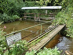
 Weir northeast of Laimnau Weir northeast of Laimnau | |
| Location | |
| Location | Germany |
| Reference no. | DE: 215292 |
| Physical characteristics | |
| Source | |
| • location | Near Obereisenbach |
| • coordinates | 47°41′23″N 9°38′39″E / 47.68972°N 9.64417°E / 47.68972; 9.64417 |
| • elevation | around 510 m above sea level (NN) |
| Mouth | |
| • location | Near Laimnau into the Argen |
| • coordinates | 47°38′04″N 9°37′44″E / 47.63444°N 9.62889°E / 47.63444; 9.62889 |
| • elevation | around 431 m above sea level (NN) |
| Length | 7.8 km |
| Basin features | |
| Progression | Argen→ Lake Constance→ Rhine→ North Sea |
The Bollenbach is a roughly 7.8-kilometre-long stream in the German state of Baden-Württemberg within the county of Bodenseekreis. It is a right-hand tributary of the Argen.
Course
The Bollenbach rises north of the Tettnang village of Obereisenbach from several springs that lie within the forest of Arlenholz. Thereafter it flows, canalized, in a southerly direction through countryside used for agriculture. After Tannau, a village on the Upper Swabian Baroque Route, it passes through the Bollen woods. Here its course is more original. It continues southwards, running past Wiesertsweiler and through the village of Laimnau, where it finally empties into the Argen.
Tributaries
From its source to its mouth the Bollenbach picks up the waters of many unnamed streams as well as the following tributaries:
- Flockenbach (l), south of Tannau
- Kreuzweiherbach (l), near Wiesertsweiler