Bridge
| Bulla Bridge | |
|---|---|
 Bulla Bridge Bulla Bridge | |
| Coordinates | 37°37′52″S 144°48′04″E / 37.6312°S 144.8011°E / -37.6312; 144.8011 |
| Characteristics | |
| Total length | 126 feet |
| No. of spans | 4 (each of 27 feet) |
| History | |
| Designer | John C Climie |
| Constructed by | McBurnie and Ramsden |
| Opened | 1869 |
| Location | |
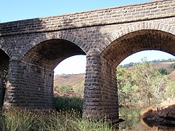
Bulla Bridge is a four span bluestone arched bridge over Deep Creek in the town of Bulla, north east of Melbourne. It was constructed in 1869 by McBurnie and Ramsden, for the Shire of Bulla to a design of Scottish-born engineer John C Climie and replaced a timber bridge built in about 1859. The bridge is 126 feet long and comprises four spans each of 27 feet. It is associated with a c.1843 road cutting and early ford which was on the main road to the Victorian gold fields.
The picturesque setting has attracted a number of artists and photographers including the woodcut by Eveline Winifred Syme in the 1930s, and numerous historic photographs.
References
- National Trust Register
- Moloney, D and Johnston, V. 1998, City of Hume: Heritage Study of the Former Shire of Bulla District, 1998 TPB/08
- Eveline Syme, woodcut entitled "Bulla Bridge" National Gallery of Australia ;
- "Walking Melbourne". Archived from the original on 26 July 2011. Retrieved 9 November 2010.
- Notes
- Colin O'Connor, Spanning Two Centuries, Historic Bridges of Australia. University of Queensland Press, 1985. p. 103
This article about a bridge in Australia is a stub. You can help Misplaced Pages by expanding it. |
This article about a building or structure in Victoria (state) is a stub. You can help Misplaced Pages by expanding it. |