| Caher | |
|---|---|
| Cathair na Féinne | |
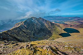
 Caher Ridge, with Caher East Top (l) and Caher West Top (r); as seen from Carrauntoohil Caher Ridge, with Caher East Top (l) and Caher West Top (r); as seen from Carrauntoohil | |
| Highest point | |
| Elevation | 1,000 m (3,300 ft) |
| Prominence | 99.76 m (327.3 ft) |
| Isolation | 0.71 miles (1.14 km) |
| Listing | Furth, Hewitt, Arderin, Simm, Vandeleur-Lynam |
| Coordinates | 51°59′40″N 9°45′31″W / 51.994449°N 9.758549°W / 51.994449; -9.758549 |
| Naming | |
| English translation | stone fort of the Fianna |
| Language of name | Irish |
| Geography | |
 Republic of Ireland | |
| Parent range | MacGillycuddy's Reeks |
| OSI/OSNI grid | V792838 |
| Topo map | OSI Discovery 78 |
| Geology | |
| Mountain type(s) | Purple sandstone & siltstone, (Ballinskelligs Sandstone Formation) |
| Climbing | |
| Easiest route | via Coomloughra Horseshoe |
Caher or Caher East Top (Irish: Cathair na Féinne, meaning 'stone fort of the Fianna') at 1,000 metres (3,300 ft), is the third-highest peak in Ireland, on the Irish Arderin and Vandeleur-Lynam classifications. It is part of the MacGillycuddy's Reeks in County Kerry.
Geography

Caher is Ireland's third-highest peak. The mountain lies to the southwest of Carrauntoohil, Ireland's highest peak at 1,038.6 metres (3,407 ft 6 in), in the MacGillycuddy's Reeks range in County Kerry.
Caher is often climbed as part of the Coomloughra Horseshoe, which takes 6–8 hours and is described as "one of Ireland’s classic ridge walks". It takes in the circuit of neighbouring peaks of Caher West Top, Carrauntoohil, The Bones, Beenkeragh, and Skregmore. On Caher's western slopes is the townland of Derrynafeana (Irish: Doire na Féinne, meaning 'oak wood of the Fianna').
Climbers refer to the narrow path that runs along the top of Caher West Top and neighboring Caher, as the Caher Ridge.
Caher is the 200th–highest mountain in Britain and Ireland on the Simm classification. Caher is regarded by the Scottish Mountaineering Club ("SMC") as one of 34 Furths, which is a mountain above 3,000 ft (914.4 m) in elevation, and meets the other SMC criteria for a Munro (e.g. "sufficient separation"), but which is outside of (or furth) Scotland; which is why Caher is sometimes referred to as one of the 13 Irish Munros. Caher's prominence qualifies it to meet the Arderin classification, and the British Isles Simm and Hewitt classifications. Caher does not appear in the MountainViews Online Database, 100 Highest Irish Mountains, as it is below the required the prominence threshold of 100 m (328 ft).

See also
- Lists of mountains in Ireland
- List of mountains of the British Isles by height
- List of Furth mountains in the British Isles
References
- ^ MountainViews: Caher (Cathair)
- Paul Tempan (February 2012). "Irish Hill and Mountain Names" (PDF). MountainViews.ie.
- ^ Ryan, Jim (2006). Carrauntoohil and MacGillycuddy's Reeks: A Walking Guide to Ireland's Highest Mountains. Collins Press. ISBN 978-1905172337.
- ^ Dillion, Paddy (1993). The Mountains of Ireland: A Guide to Walking the Summits. Cicerone. ISBN 978-1852841102.
- "Route Descriptions". Kerry Mountain Rescue Teams. 2018.
- Derrynafeana. Placenames Database of Ireland.
- "Hiking Carrauntoohil: Everything you Need to Know". Outside.ie. 2017.
The trail will take you along the really scenic Caher Ridge Path with great views and takes in the summit of the Caher Mountain, before you descend a little to the col on the way to Carrauntoohil.
- ^ Cocker, Chris; Jackson, Graham (2018). "The Database of British and Irish Hills". Database of British and Irish Hills.
- Mountains – Key Facts. The Munros, Corbetts, Grahams, Donalds & Furths Archived 2012-08-22 at the Wayback Machine at www.smc.org.uk. Accessed on 5 Feb 2013.
- Mountainviews, (September 2013), "A Guide to Ireland's Mountain Summits: The Vandeleur-Lynams & the Arderins", Collins Books, Cork, ISBN 978-1-84889-164-7
External links
- MountainViews: The Irish Mountain Website, Caher
- MountainViews: Irish Online Mountain Database
- The Database of British and Irish Hills , the largest database of British Isles mountains ("DoBIH")
- Hill Bagging UK & Ireland, the searchable interface for the DoBIH
- Ordnance Survey Ireland ("OSI") Online Map Viewer
- Logainm: Placenames Database of Ireland
| Mountains and hills of Great Britain and Ireland | ||
|---|---|---|
| British Isles |  | |
| Scotland | ||
| Outside Scotland | ||
| England | ||
| Ireland | ||
| County tops | ||
