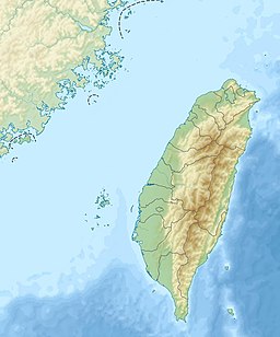
| New Caoling Lake | |
|---|---|
| 新草嶺潭 (Chinese) | |
 | |
| Location | Gukeng, Yunlin and Meishan, Chiayi |
| Coordinates | 23°34′33″N 120°41′36″E / 23.5759°N 120.6934°E / 23.5759; 120.6934 |
| Type | Barrier lake |
| River sources | Qingshui River |
| First flooded | September 21, 1999 (1999-09-21) |
| Max. length | 5 km (3.1 mi) |
| Max. depth | 58 m (190 ft) |
| Water volume | 46,000,000 m (1.6×10 cu ft) |
| References | |
New Caoling Lake (Chinese: 新草嶺潭; pinyin: Xīn Cǎolǐng Tán) was a short-lived barrier lake on the border of Gukeng, Yunlin County and Meishan, Chiayi County, near the village of Caoling in Taiwan. Located on the Qingshui River, a tributary of the Zhuoshui River, the lake formed due to a landslide during the 1999 Jiji earthquake on September 21, 1999. The lake disappeared during a flood caused by Typhoon Mindulle in July 2004.
Past lakes
The area around Caoling is mountainous and prone to landslides. Historically, there have been four instances of barrier lakes forming in this area. The first recorded instance was during the 1862 Tainan earthquake, and lasted until 1898. During the 1941 Chungpu earthquake, a landslide formed a 70 m tall dam; in 1942, another landslide caused the dam to grow to 170 m tall. On 18 May 1951, the dam abruptly failed, killing hundreds of people downstream, including 74 soldiers constructing a road up to the lake. On 15 August 1979, a landslide caused by 1979 typhoons caused a lake to form, which failed on 24 August the same year.
History
During the 1999 Jiji earthquake on September 21, 1999, a landslide west of Caoling formed a 50 m tall barrier that once again dammed up the Qingshui River. After the earthquake, the Water Resources Agency announced that the lake's dam was stable, and the newly formed lake could potentially be used as a reservoir and serve as a substitute for Shigang Dam, which was damaged in the earthquake. However, this plan was never carried out.
Though the lake covered over some of Caoling's scenic attractions, the new lake was still popular among tourists. However, the lake was short-lived, as sedimentation gradually raised the lake's floor. Also, water channels formed on the dam, which decreased the retention time of the water. In July 2004, a flood caused by Typhoon Mindulle (known as the Seven-Two Flood) raised the lake's surface above the dam, washing away the barrier and returning the river to its original state.
References
- ^ 李建堂. "變遷中的地景 「新草嶺潭」的地景變遷". National Taiwan University (in Chinese (Taiwan)). Archived from the original on 17 March 2016. Retrieved 15 November 2020.
- 蘇榮泉; 郭春輝 (20 September 2019). "九二一走過20年 夢幻草嶺潭、大飛山成為永遠印記" (in Chinese (Taiwan)). Now News. Retrieved 15 November 2020.
- ^ 何立德. "草嶺潭". Encyclopedia of Taiwan (in Chinese (Taiwan)). Ministry of Culture. Retrieved 15 November 2020.
- 張炎銘 (3 October 2014). "1951年5月18日-草嶺潭崩潰". Water Resources Agency (in Chinese (Taiwan)). Retrieved 15 November 2020.
- 劉在武 (24 September 1999). "新草嶺潭 蓄水量相當石門水庫" (in Chinese (Taiwan)). China Times. Archived from the original on 9 August 2014. Retrieved 15 November 2020.
- 王晴玲 (30 September 2004). "再見‧草嶺潭". Our Island (in Chinese (Taiwan)). Public Television Service. Retrieved 15 November 2020.
Notes
- The name "Caoling Lake" typically refers to all four instances of this lake, while "New Caoling Lake" only refers to the 1999-2004 lake.