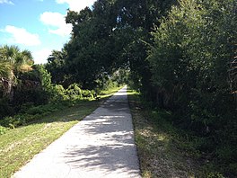
| Cape Haze Pioneer Trail | |
|---|---|
 | |
| Length | 8 mi (13 km) |
| Location | Placida, Florida, United States |
| Established | 1999 |
| Trailheads | North: 26°55′58″N 82°13′34″W / 26.9329°N 82.2262°W / 26.9329; -82.2262 Pinedale Drive and South McCall Road South: 26°50′01″N 82°15′55″W / 26.8335°N 82.2653°W / 26.8335; -82.2653 Placidia Road and Boca Grande Causeway |
| Season | Year round |
| Hazards | Weather |
| Surface | Asphalt |
| Right of way | Charlotte Harbor and Northern Railway |
| Website | |
| Trail map | |
| Map of the Cape Haze Pioneer Trail | |
The Cape Haze Pioneer Trail is an 8-mile (13 km) rail trail in Charlotte County, Florida, on the Cape Haze peninsula running from western Port Charlotte to Placida. A vast majority of the trail runs along the right of way of the former Charlotte Harbor and Northern Railway.
Route description

The trail begins at the intersection of State Road 776 and Pinedale Drive in western Port Charlotte. It runs south along Pinedale Drive briefly before shifting east on to the former railroad corridor. It then proceeds south along the railroad corridor, passing near Rotonda West and crossing over Coral Creek near Coral Creek Airport. At the Coral Creek Country Club, the trail leaves the railroad corridor and runs alongside County Road 771 to Placida, terminating just north of the Boca Grande Causeway.
From here, bicyclists can continue across the causeway to Gasparilla Island and the Boca Grande Bike Path (which runs along the island portion of the railroad corridor).
History

The Charlotte Harbor and Northern Railway, which served Gasparilla Island, existed from 1907 until 1981. Charlotte County gained ownership of the right of way in 1985, and the first portion of the trail was built in 1999 from the Mercer trailhead to Rotonda Boulevard. It was extended over Coral Creek to the Coral Creek Golf Club in 2005. The southernmost portion along County Road 771 from Coral Creek Country Club to Placida was completed in 2010.
Originally, the trail was planned to continue along the railroad corridor all the way to Placida before the Coral Creek Country Club was built, which used up a portion of the corridor. The remaining portion was built along County Road 771. A new bridge carrying CR 771 over Coral Creek was built to accommodate bicycle and pedestrian traffic as part of the trail extension in 2010.
See also
References
- Two Florida Trails, Worlds Apart
- Turner, Gregg M. (December 1, 1999). Railroads of Southwest Florida. Images of America. Arcadia Publishing.
- "Pioneer Trail back on track after golf club's bankruptcy raises doubts". Sarasota Herald-Tribune. February 19, 2004. Retrieved July 17, 2013.
External links
- Cape Haze Pioneer Trail Park (Official Web Page)
- TrailLink profile for Cape Haze Pioneer Trail
- Cape Haze Pioneer Trail at 100 Florida Trails