| Native name: Isla Carenero | |
|---|---|
 Bocas del Toro Archipelago Bocas del Toro Archipelago | |
| Geography | |
| Coordinates | 9°21′N 82°14′W / 9.350°N 82.233°W / 9.350; -82.233 |
| Archipelago | Bocas del Toro Archipelago |
| Area | 0.94 km (0.36 sq mi) |
| Highest elevation | 0 m (0 ft) |
| Administration | |
| Panama | |
| Province | Bocas del Toro |
| District | Bocas del Toro |
| Corregimiento | Bocas del Toro |
| Demographics | |
| Population | 737 (2000) |
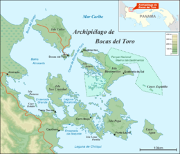
Carenero Island (in Spanish: Isla Carenero) is a long and forested island located just a few hundred meters east of Isla Colón, in the Bocas del Toro Archipelago, Panama. The name of the island comes from the nautical term careening, which means to lean a ship on its side for repairing or scraping its hull. There are no roads on the island.
See also
References
- McCarthy, Carolyn (2010), Lonely Planet Panama, Lonely Planet, p. 215, ISBN 978-1-74179-154-9
- Woods, Sarah (2005), Panama: The Bradt Travel Guide, Bradt Travel Guides, p. 261, ISBN 1-84162-117-X
| Islands |  | |
|---|---|---|
| Protected areas | ||
| Settlements |
| |
This article about the geography of Bocas del Toro Province is a stub. You can help Misplaced Pages by expanding it. |