Misplaced Pages

Caricuao

Article snapshot taken from[REDACTED] with creative commons attribution-sharealike license. Give it a read and then ask your questions in the chat. We can research this topic together.
Municipality in Miranda, Venezuela
Caricuao Municipality Municipio Chacao
Municipality
Buildings in ChacaoBuildings in Chacao
Location in MirandaLocation in Miranda
Map showing the location of Chacao Municipality within VenezuelaMap showing the location of Chacao Municipality within VenezuelaCaricuao MunicipalityLocation in Venezuela
Coordinates: 10°26′N 66°59′W / 10.43°N 66.98°W / 10.43; -66.98
Country Venezuela
StateMiranda
MunicipalityLibertador municipality
Time zoneUTC−4 (VET)
Area code(s)0234
[edit on Wikidata]
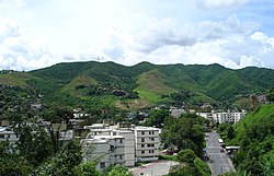
A view of Caricuao

Caricuao (Spanish pronunciation: [kaɾiˈkwao]) is a district of Caracas, Venezuela. It is part of Libertador municipality.

It is named after a powerful indigenous chief of the Caracas tribe, who fought bravely against the Spaniard Conquistadores; he and Tiuna chief were the first indigenous leaders to set up "armies" on their tribes to organize the battles against their enemies, the Spanish, to which they inflicted great losses as the native indigenous tribes were fighting the Spanish settlement.

Caricuao is known as the second vegetal reserve of Caracas. The most important public zoo of the capital, the Parque Zoológico Caricuao, is located there.

Since its foundation in 1961 it has had a strong cultural movement especially in the music, the first rocksteady, reggae and ska bands of Venezuela were born in this neighborhood, for this it is also known as "The Independent Republic of Reggae and Ska". From Caricuao broadcasts "Radio Perola", one of the most emblematic independent community radio stations in the nation.

Since it is a large neighborhood, it is possible to get there on several Caracas Metro stations on Line 2 (the green one) such as Caricuao, Ruiz Pineda, and Zoológico. A new subway line opened in October 2006 to connect Las Adjuntas, a neighboring suburb, and Caracas to Los Teques, capital city of Miranda State and an important pole of development.

External links

10°26′N 66°59′W / 10.433°N 66.983°W / 10.433; -66.983

Parishes of the Libertador Bolivarian Municipality
South
Parish map
Parish map
West
Central
East
Caracas Divisions
Northwest
  • Catia
  • 23 de Enero
  • Propatria
  • Lomas de Urdaneta
  • Casalta
  • El Atlántico
  • Caño Amarillo
  • Los Magallanes de Catia
  • Alta Vista
  • Ruperto Lugo
  • Lídice
  • Gramoven
  • Manicomio
Flag of Caracas
Flag of Caracas
Center
  • El Silencio
  • Capitolio
  • La Hoyada
  • Altagracia
  • La Pastora
  • Cotiza
  • Quinta Crespo
  • Guaicaipuro
  • La Candelaria
  • San Bernardino
Southwest
  • Artigas
  • Vista Alegre
  • Bella Vista
  • Colinas de Vista Alegre
  • La Yaguara
  • Zona Industrial de La Yaguara
  • El Algodonal
  • Carapa
  • Antímano
  • Washington
  • Las Fuentes
  • El Paraíso
  • El Pinar
  • La Paz
  • El Paraíso
  • Montalbán
  • Juan Pablo II
  • La Vega
  • Las Adjuntas
  • Caricuao
  • Mamera
Centereastern
  • El Conde
  • Parque Central
  • San Agustín del Sur
  • San Agustín del Norte
  • Simón Rodríguez
  • Maripérez
  • La Colina
  • Las Palmas
  • Las Lomas
  • San Rafael
  • Los Caobos
  • Quebrada Honda
  • San Bernardino
South
  • Cementerio
  • Los Carmenes
  • Los Castaños
  • Prado de Maria
  • La Bandera
  • Las Acacias
  • Colinas de las Acacias
  • Los Rosales
  • Valle Abajo
  • Los Chaguaramos
  • Ciudad Universitaria
  • Santa Mónica
  • Colinas de Santa Mónica
  • Colinas de Bello Monte
  • Cumbres de Curumo
  • El Valle
  • Los Jardines de El Valle
  • Coche
  • Delgado Chalbaud
  • La Rinconada
Eastern
  • La Campiña
  • La Florida
  • Alta Florida
  • Chapellín
  • Los Cedros
  • El Bosque
  • Chacaíto
  • Sabana Grande
  • Bello Monte
  • Country Club
  • El Pedregal
  • San Marino
  • Campo Alegre
  • Chacao
  • Bello Campo
  • El Rosal
  • El Retiro
  • Las Mercedes
  • Tamanaco
  • Chuao
  • Altamira
  • Los Palos Grandes
  • La Castellana
  • La Floresta
  • Santa Eduvigis
  • Sebucán
  • La Carlota
  • Santa Cecilia
  • Campo Claro
  • Los Ruices
  • Montecristo
  • Los Chorros
  • Los Dos Caminos
  • Boleíta
  • Los Cortijos
  • La California
  • Horizonte
  • El Marqués
  • La Urbina
  • Terrazas del Ávila
  • Lomas del Ávila
  • El Llanito
  • Macaracuay
  • La Guairita
  • Caurimare
  • El Cafetal
  • San Román
  • Santa Rosa
  • San Luis
  • Santa Sofía
  • Santa Paula
  • Santa Inés
  • Los Pomelos
  • Palo Verde
  • Petare
Southeastern
  • Valle Arriba
  • Santa Fe
  • Los Campitos
  • Prados del Este
  • Alto Prado
  • Manzanares
  • El Peñón
  • Baruta
  • Piedra Azul
  • La Trinidad
  • La Tahona
  • Monterrey
  • Las Minas
  • Los Samanes
  • Cerro Verde
  • Los Naranjos
  • La Boyera
  • Alto Hatillo
  • El Hatillo
  • Los Geranios
  • La Lagunita
  • El Placer
  • El Guayabao
  • El Volcán
  • La Unión
  • Sartanejas
Category:
Caricuao Add topic