| This article includes a list of references, related reading, or external links, but its sources remain unclear because it lacks inline citations. Please help improve this article by introducing more precise citations. (June 2024) (Learn how and when to remove this message) |

The château de Sainte-Alvère, also known as the château de Lostanges is a medieval castle in the town of Sainte-Alvère, in the commune of Val de Louyre et Caudeau in the department of Dordogne, in the Nouvelle-Aquitaine in France.
History
A first lord, Pierre de Limeuil, was mentioned in 1284. In 1448, the castle came into the possession of the Lostanges family, who owned it until the French Revolution. In 1778, the castle was described as "vast, surrounded by a beautiful moat flanked by beautiful towers, and surrounded by walls that in the past may have been its defence". In 1795, a large part of the castle was demolished, as ordered by Joseph Lakanal, administrator of the Dordogne department.
Architecture
Of the castle and its enclosure, several remains have survived.
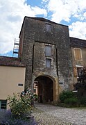
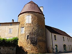
The tour maîtresse (master tower) is the only remnant of the actual castle. It is a circular tower 18 metres (59 ft) high with a diamter of 8.8 metres (29 ft), composed of four levels. Often referred to as a keep, it is actually not the original main tower of the 13th century castle, but a more modest tower from the late 15th century, endowed with gunholes. The gatehouse is a 15 metres (49 ft) high rectangular tower. It provided access to the castle by means of a drawbridge. Currently, the gatehouse is undergoing restoration. The tour des dames (ladies' tower) is located at the north-west corner of the enclosure. The gendarmerie tower is located at the northermost part of the enclosure, close to the former gendarmerie building. Like the ladies' tower, its ground plan is horseshoe-shaped. The north-east tower has a horseshoe-shaped ground plan, flattened at the salient. It has a mansard roof which may date from the 17th century.
The dovecote is a small tower is located not far from the south-east corner of the enclosure, and has several pigeonholes.
Protection
The castle has been inscribed as a monument historique by the French Ministry of Culture since 1948.
Gallery
-
 The master tower
-
 The gatehouse or châtelet
-
 The ladies' tower
-
 The gendarmerie tower
-
 The north-east tower
-
 The dovecote
See also
Reference
- ^ Base Mérimée: Restes de la tour de Saint-Alvere, Ministère français de la Culture. (in French)
Bibliography
- Anne Bécheau, Histoire du château et des remparts de Sainte-Alvère. Dossier documentaire, 2022.
- Cyril Yovitchitch, Le château et les fortifications de Sainte-Alvère. Diagnostic sommaire d’archéologie du bâti, 2023.
External links
- HelloAsso - Les Défenseurs du Châtelet, association for the protection Sainte-Alvère's medieval heritage
44°56′46″N 0°48′33″E / 44.9462°N 0.8091°E / 44.9462; 0.8091
Categories: