| Cutzamala de Pinzón | |
|---|---|
| Municipality | |
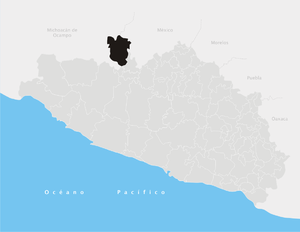
 Municipality of Cutzamala de Pinzón in Guerrero Municipality of Cutzamala de Pinzón in Guerrero | |
 | |
| Coordinates: 18°24′N 100°28′W / 18.400°N 100.467°W / 18.400; -100.467 | |
| Country | |
| State | Guerrero |
| Municipal seat | Cutzamala de Pinzón |
| Area | |
| • Total | 611.1 km (235.9 sq mi) |
| Population | |
| • Total | 20,730 |
Cutzamala de Pinzón is a municipality in the Mexican state of Guerrero and is the northernmost municipality in Guerrero. The municipal seat lies at Cutzamala de Pinzón. The municipality covers an area of 611.1 km.
As of 2005, the municipality had a total population of 20,730.
Demographics
As of the 2020 census, the population of the municipality was 21,388. The 5 largest towns in order of population are:
| Town | Population 2020 | Elevation |
|---|---|---|
| Cutzamala de Pinzón | 4,717 | 278 m |
| Zacapuato | 1,697 | 376 m |
| Tamácuaro | 931 | 373 m |
| Arroyo Grande | 837 | 330 m |
| Nuevo Galeana | 747 | 314 m |
References
- "Cutzamala de Pinzón". Enciclopedia de los Municipios de México. Instituto Nacional para el Federalismo y el Desarrollo Municipal. Archived from the original on September 27, 2007. Retrieved December 23, 2008.
- "Localidades de Cutzamala de Pinzón (Municipio en Guerrero)". mexico.PueblosAmerica.com (in Mexican Spanish). Retrieved 2022-07-13.
- "Cutzamala de Pinzón topographic map, elevation, relief". topographic-map.com. Retrieved 2022-07-13.
This article about a location in the Mexican state of Guerrero is a stub. You can help Misplaced Pages by expanding it. |