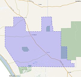
Local government area in South Australia
| District Council of Coonalpyn Downs South Australia | |
|---|---|
 Approximate extent in 1957 Approximate extent in 1957 | |
 | |
| Coordinates | 35°41′54″S 139°51′19″E / 35.6983°S 139.855246°E / -35.6983; 139.855246 |
| Population | 1,950 (1986) |
| • Density | 0.4802/km (1.244/sq mi) |
| Established | 1957 |
| Abolished | 1997 |
| Area | 4,061 km (1,568.0 sq mi)(1986) |
| Council seat | Coonalpyn |
The District Council of Coonalpyn Downs was a local government area in the Australian state of South Australia that existed from 1957 to 1997 on land in the state’s south-east.
It was established on 30 May 1957 with its seat being located in the town of Coonalpyn.
At establishment, the district consisted of land in the hundreds of Jeffries, Strawbridge, Coneybeer, Lewis, Field, Colebatch, Richards and Coombe and parts of the hundreds of Archibald, Carcuma and Kirkpatrick. The district therefore included parts of the cadastral counties of Buccleuch, Russell, Cardwell and Buckingham.
At establishment, councillors were elected from the following five wards with all returning two councillors each with the exception of Yumali which returned one councillor – Coonalpyn, Mclntosh, Richards, Tintinara and Yumali.
On 13 February 1997, it was amalgamated with the district councils of Meningie and Peake to create the Coorong District Council.
Chairmen
| This list is incomplete; you can help by adding missing items. (April 2019) |
The following persons were elected to serve as chairman of the council for the following terms:
- Hedley Ivan George Prosser (1957–59)
- Malcolm Chisholm McIntosh (1959–61)
- Hedley Ivan George Prosser (1961–65)
- John Edgar Calvert (1965–68)
- Eric Thomas Filmer (1968–70)
- Glen Thomas Goodall (1970–72)
- William Brownlow Ashby (1972–74)
- Donald James Edmonds-Wilson (1974–76)
- William Brownlow Ashby (1976–78)
- Donald James Edmonds-Wilson (1978–80)
- Albert George Webb (1980–82)
- Glen Thomas Goodall (1982–85)
- Pitre Julian Desmazures (1985–?)
References
- ^ "Search results for "Coonalpyn, GTWN" with the following datasets selected - 'Counties', 'Government Towns', 'Hundreds' and 'Gazetteer'". Location SA Map Viewer. Government of South Australia. Retrieved 16 April 2019.
- ^ Matthews, Penny (1986), South Australia, the civic record, 1836-1986, Wakefield Press, pp. 127–132, ISBN 978-0-949268-82-2
- ^ Rowe, Colin D. (30 May 1957). "LOCAL GOVERNMENT ACT, 1934-1957: CONSTITUTION OF DISTRICT COUNCIL DISTRICT OF COONALPYN DOWNS" (PDF). The South Australian Government Gazette. Government of South Australia. pp. 1377–1378. Retrieved 6 April 2019.
- ^ Kerin, R.G. (13 February 1997). "LOCAL GOVERNMENT ACT 1934 SECTIONS 7 AND 14: AMALGAMATION OF THE DISTRICT COUNCIL OF COONALPYN DOWNS, THE DISTRICT COUNCIL OF MENINGIE AND THE DISTRICT COUNCIL OF PEAKE" (PDF). The Government Gazette of South Australia. Government of South Australia. pp. 900–903. Retrieved 6 April 2019.