| Dodge #4 State Park | |
|---|---|
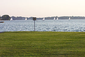
 A view of Cass Lake with sailboats A view of Cass Lake with sailboats | |
  | |
| Location | West Bloomfield Township, Oakland County, Michigan, United States |
| Nearest city | Keego Harbor, Michigan |
| Coordinates | 42°37′00″N 83°22′04″W / 42.61667°N 83.36778°W / 42.61667; -83.36778 |
| Area | 139 acres (56 ha) |
| Elevation | 929 feet (283 m) |
| Established | 1922 |
| Administered by | Michigan Department of Natural Resources |
| Designation | Michigan state park |
| Website | Official website |
Dodge No. 4 State Park is a public recreation area covering 139 acres (56 ha) on the north shore of Cass Lake in Oakland County, northern Metro Detroit, Michigan. The state park occupies a mile of shoreline on the 1,280-acre (520 ha) lake.
History
The park was created in 1922 when Dodge Brothers Corporation donated the land, stipulating that it be maintained as a public park in perpetuity.
Activities and amenities
The park offers swimming, fishing for bass, pike, perch and trout, a fishing pier, picnicking facilities, and boat ramp.
References
- ^ "Hess Lake". Geographic Names Information System. United States Geological Survey, United States Department of the Interior.
- "When were Michigan state parks and recreation areas established?" (PDF). Michigan Department of Natural Resources. Retrieved April 25, 2020.
- ^ "Dodge No. 4 State Park". Michigan Department of Natural Resources. Retrieved November 6, 2024.
- Institute for Fisheries Research. "Lake Inventory Map: Cass Lake" (PDF). Michigan Department of Natural Resources. Retrieved November 6, 2024.
External links
- Dodge No. 4 State Park Michigan Department of Natural Resources
- Dodge No. 4 State Park Map Michigan Department of Natural Resources