| Dolnji Slaveči Alsócsalogány | |
|---|---|
 | |
 | |
| Coordinates: 46°47′45.93″N 16°4′7.38″E / 46.7960917°N 16.0687167°E / 46.7960917; 16.0687167 | |
| Country | |
| Traditional region | Prekmurje |
| Statistical region | Mura |
| Municipality | Grad |
| Area | |
| • Total | 5.52 km (2.13 sq mi) |
| Elevation | 239.7 m (786.4 ft) |
| Population | |
| • Total | 397 |
| • Density | 72/km (190/sq mi) |
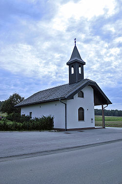
Dolnji Slaveči (pronounced [ˈdoːlnji ˈslaːʋɛtʃi]; Hungarian: Alsócsalogány) is a village in the Municipality of Grad in the Prekmurje region of northeastern Slovenia.
Name
The name Dolnji Slaveči (literally, 'lower Slaveči') contrasts with the name Gornji Slaveči (literally, 'upper Slaveči'), a village in the neighboring Municipality of Kuzma. Gornji Slaveči lies about 20 meters (66 ft) higher in elevation than Dolnji Slaveči.
Notable people
Notable people that were born or lived in Dolnji Slaveči include:
- Miklós Küzmics (1737–1804), Hungarian Slovene writer and translator
- Anton Vratuša (1915–2017), politician and diplomat
References
- Statistical Office of the Republic of Slovenia
- Vengušt, Jernej. 1919. Seznamek prekmurskih občin (krajev) z označbo pošte in zemljevidom. Radgona, p. 13.
- Grad municipal site Archived 2012-02-27 at the Wayback Machine
- Slovenian Academy of Sciences and Arts site
External links
| Municipality of Grad | ||
|---|---|---|
| Settlements | Administrative seat: Grad |  |
| Landmarks |
| |
| Notable people | ||
This article about the Municipality of Grad in Slovenia is a stub. You can help Misplaced Pages by expanding it. |