Human settlement in England
| Fangfoss | |
|---|---|
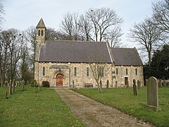
 Saint Martins Church, Fangfoss Saint Martins Church, Fangfoss | |
 | |
 | |
| Population | 581 (2011 census) |
| OS grid reference | SE765532 |
| • London | 170 mi (270 km) S |
| Civil parish |
|
| Unitary authority | |
| Ceremonial county | |
| Region | |
| Country | England |
| Sovereign state | United Kingdom |
| Post town | YORK |
| Postcode district | YO41 |
| Dialling code | 01759 |
| Police | Humberside |
| Fire | Humberside |
| Ambulance | Yorkshire |
| UK Parliament | |
| 53°58′10″N 0°50′02″W / 53.969524°N 0.833846°W / 53.969524; -0.833846 | |
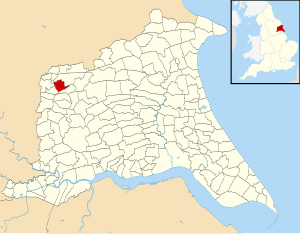
Fangfoss is a village and civil parish in the East Riding of Yorkshire, England. It is situated approximately 11 miles (18 km) to the east of the city of York and 3.5 miles (6 km) north-west of the town of Pocklington. The parish includes Bolton. The civil parish is called "Fangfoss" and its parish council is called "Fangfoss with Bolton Parish Council" after Bolton parish was abolished on 1 April 1935 and merged with Fangfoss. The parish covers an area of 900.98 hectares (2,226.4 acres). In 2011 it had a population of 581, a decrease on the 2001 UK census figure of 602.
In 1823 Fangfoss was listed as the parish of 'Fangfoss-with-Spittle'. The village was in the Wapentake of Harthill. Population was 154, with occupations including twelve farmers, a shopkeeper, a shoemaker, and a schoolmaster. The landlord of The Carpenter's public house was also a village carpenter. The village chapel was in the charge of the vicar of Barnby-upon-the-Moor, and under the patronage of the Dean of York.

The parish church of St Martin was designated a Grade II* listed building in January 1967 and is now recorded in the National Heritage List for England, maintained by Historic England.
Fangfoss Hall was designated a Grade II* listed building in 1967 and is now recorded in the National Heritage List for England, maintained by Historic England.

Fangfoss was served by Fangfoss railway station on the York to Beverley Line between 1847 and 1959. In 1987 the station was given a Grade II listed building status.
In addition to the parish church, Fangfoss has a primary school and pub called The Carpenters Arms. A village park was created in 2002 to mark the Queen's Golden Jubilee and is called Jubilee Park.
Fangfoss hosts an annual arts festival called Fangfest – Fangfoss Festival of Practical Arts, which takes place every September and is a celebration of local traditional arts and crafts.
References
- ^ UK Census (2011). "Local Area Report – Fangfoss Parish (1170211178)". Nomis. Office for National Statistics. Retrieved 18 February 2018.
- "Fangfoss". Ordnance Survey. Retrieved 4 February 2021.
- "Your Parish Council". Fangfoss with Bolton Parish Council. Retrieved 4 February 2021.
- "Relationships and changes Fangfoss CP/AP/Ch through time". A Vision of Britain through Time. Retrieved 4 February 2021.
- "2001 Census Area Profile" (PDF). East Riding of Yorkshire Council. 2004. Archived from the original (PDF) on 18 March 2012. Retrieved 8 February 2013.
- UK Census (2001). "Local Area Report – Fangfoss Parish (1543504224)". Nomis. Office for National Statistics. Retrieved 11 December 2018.
- Baines, Edward (1823). History, Directory and Gazetteer of the County of York. p. 203.
- Historic England. "Church of St Martin (1083833)". National Heritage List for England. Retrieved 29 April 2013.
- Historic England. "Fangfoss Hall (1346460)". National Heritage List for England. Retrieved 15 August 2013.
- Butt, R. V. J. (October 1995). The Directory of Railway Stations: details every public and private passenger station, halt, platform and stopping place, past and present (1st ed.). Sparkford: Patrick Stephens Ltd. p. 94. ISBN 978-1-85260-508-7. OCLC 60251199. OL 11956311M.
- Historic England. "The old railway station (1346458)". National Heritage List for England. Retrieved 29 April 2013.
- "Background". Jubilee Park. Retrieved 25 November 2014.
- Atkins, Duncan (24 August 2022). "Fangfest – Festival of Practical Arts: here are some of the artists and craftspeople taking part". The Yorkshire Post. Retrieved 25 June 2024.
- Baggs, A. P.; Kent, G. H. R.; Purdy, J. D. (1976). Allison, K. J. (ed.). "Fangfoss". A History of the County of York East Riding: Volume 3: Ouse and Derwent wapentake, and part of Harthill wapentake. Institute of Historical Research. pp. 164–170. Retrieved 29 April 2013.
- Gazetteer — A–Z of Towns Villages and Hamlets. East Riding of Yorkshire Council. 2006. p. 5.
External links
- [REDACTED] Media related to Fangfoss at Wikimedia Commons
- Fangfoss in the Domesday Book
| Yorkshire Portal | |
| Statutory City Region | Hull and East Yorkshire Combined Authority |
| Unitary authorities | |
| Major settlements (cities in italics) | |
| Rivers | |
| Canals | |
| Topics | |