| This article uses bare URLs, which are uninformative and vulnerable to link rot. Please consider converting them to full citations to ensure the article remains verifiable and maintains a consistent citation style. Several templates and tools are available to assist in formatting, such as reFill (documentation) and Citation bot (documentation). (September 2022) (Learn how and when to remove this message) |
| Fort Corchaug Archeological Site | |
| U.S. National Register of Historic Places | |
| U.S. National Historic Landmark | |
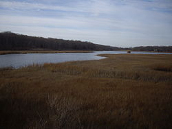
 Fort Corchaug Vicinity Fort Corchaug Vicinity | |
  | |
| Location | Cutchogue, Town of Southold, NY |
|---|---|
| Coordinates | 41°00′09.66″N 72°29′55.48″W / 41.0026833°N 72.4987444°W / 41.0026833; -72.4987444 |
| NRHP reference No. | 74001308 |
| Significant dates | |
| Added to NRHP | January 18, 1974 |
| Designated NHL | January 20, 1999 |
Fort Corchaug Archeological Site is a prehistoric archaeological site in Cutchogue on eastern Long Island in New York State. It is located west of the North Fork Country Club, on the south side of Main Road (New York State Route 25). The site shows evidence of 17th century contact between Native Americans and Europeans. Fort Corchaug itself was a log fort built by Native Americans. It may have been to protect the Corchaug tribe from other Indians, built with the help of Europeans. Ralph Solecki, a prominent American archaeologist, grew up nearby and conducted several digs on site.
It remains today one of the few undisturbed Native American fortified village sites in the North East. and was declared a National Historic Landmark in 1999. The 105-acre (42 ha) property where the fort is located is protected in part by a conservation easement owned by a local land trust, and is in part owned by the town of Southold as a nature preserve. Known as the Downs Farm Preserve, it is open to the public with hiking trails.
The Corchaug tribe, also known as the Montaukett, originally had the land from the Nassau border to Montauk Point. Depradation by the Narragansetts of Connecticut and decimation from smallpox caused to tribe to leave their land in the South Fork and with the help of whites built forts to ward off attacks. Another fort still being excavated is Fort Hill (now in Montauk County Park) in Montauk Point, described as "one of the earliest and best for its time", it was placed on a 1658 map of Long Island.
References
- "National Register Information System". National Register of Historic Places. National Park Service. January 23, 2007.
- ^ "Fort Corchaug Archaelogical Site". National Historic Landmark summary listing. National Park Service. September 11, 2007. Archived from the original on June 5, 2008. Retrieved September 3, 2007.
- Newsday.com Article on Site Archived 2007-10-06 at the Wayback Machine
- NY Times article
- "Fort Corchaug History". Archived from the original on February 12, 2007. Retrieved February 9, 2008.
- "Downs Farm Preserve". Town of Southold. Retrieved April 12, 2018.
- "Downs Farm Preserve". Peconic Land Trust. Retrieved April 12, 2018.
- http://montaukett.org/?page_id=22
| U.S. National Register of Historic Places in New York | ||
|---|---|---|
| Topics |   | |
| Lists by county |
| |
| Lists by city | ||
| Other lists |
| |