| This article needs additional citations for verification. Please help improve this article by adding citations to reliable sources. Unsourced material may be challenged and removed. Find sources: "Franklin Strait" – news · newspapers · books · scholar · JSTOR (August 2010) (Learn how and when to remove this message) |

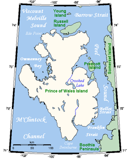
The Franklin Strait is an Arctic waterway in Northern Canada's territory of Nunavut. It is located between southeastern Prince of Wales Island and the Boothia Peninsula. It is on the south end of Peel Sound.
It is named after the English explorer Sir John Franklin (1786-1847), who perished in these waters on his lost expedition.
References
- Hopkins, Daniel J.; 편집부 (1997). Merriam-Webster's Geographical Dictionary. ISBN 9780877795469. Retrieved 2008-07-06.
- Pharand, Donat; Legault, Leonard H. (1984). The Northwest Passage: Arctic Straits. Martinus Nijhoff Publishers. p. 12. ISBN 9789024729791. Retrieved 26 July 2019.
71°30′N 096°30′W / 71.500°N 96.500°W / 71.500; -96.500 (Franklin Strait)
| Straits of Nunavut | |
|---|---|
| Kitikmeot Region | |
| Kivalliq Region | |
| Qikiqtaaluk Region | |
This Kitikmeot Region, Nunavut location article is a stub. You can help Misplaced Pages by expanding it. |