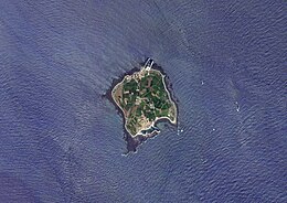
 Satellite image (2015) Satellite image (2015) | |
| Geography | |
|---|---|
| Coordinates | 33°10′10″N 126°16′18″E / 33.16944°N 126.27167°E / 33.16944; 126.27167 |
| Area | 0.84 km (0.32 sq mi) |
| Coastline | 4.2 km (2.61 mi) |
| Administration | |
| South Korea | |
| Province | Jeju |
| City | Seogwipo |
| Town | Daejeong-eup |
| Additional information | |
| Official website | wonderfulis |
Gapado (Korean: 가파도; Hanja: 加波島) is a small island 2.2 kilometers (1.4 mi) south of Jeju Island in South Korea. It is administered under Daejeong-eup, Seogwipo, Jeju Province. It has an area of 0.84 km (0.32 sq mi) and a coastline length of 4.2 km (2.6 mi). It first became regularly inhabited by humans in 1842. Haenyeo, female divers of Jeju, go diving off the island's coasts.
A ferry runs between the island and Moseulpo Port on Jeju twice daily.
The island is the location where the Dutch mariner Hendrick Hamel first became stranded in Korea in the 17th century. The island has a monument to Hamel.
Gallery
-
Scenery on the island (2012)
-
 Field of barley on the island (2011)
-
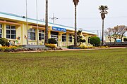
 Gapa Elementary School on the island (2011)
See also
- Marado – another island off the south coast of Jeju
References
- ^ "Gapado Island (가파도)". Gapado Island (가파도). Retrieved 2023-10-01.
- "가비아 호스팅 서비스:웹호스팅,웹메일호스팅,쇼핑몰호스팅,단독서버,동영상호스팅". errdoc.gabia.io. Retrieved 2023-10-01.
This South Korea location article is a stub. You can help Misplaced Pages by expanding it. |