| Monte I Gemelli Les Jumeaux de Mologne | |
|---|---|
| Gemelli di Mologna | |
 | |
| Highest point | |
| Elevation | 2,476 m (8,123 ft) |
| Prominence | 120 m (390 ft) |
| Coordinates | 45°43′03″N 7°55′43″E / 45.7174472°N 7.9287162°E / 45.7174472; 7.9287162 |
| Geography | |
 Les Jumeaux de MologneLocation in the Alps | |
| Location | Province of Biella / Aosta Valley, Italy |
| Parent range | Alpi Biellesi |
| Climbing | |
| Easiest route | Hiking from the Piedicavallo |
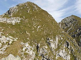
The Monte I Gemelli (or Gemelli di Mologna; French: Les Jumeaux de Mologne) is an Alpine mountain located between Aosta Valley and Piedmont (NW Italy).
Toponymy
Literally Italian: Gemelli di Mologna and French: Jumeaux de Mologne means Twins of Mologna/Mologne, where the Mologna/Mologne is a stream tributary of the river Cervo. Twins refers to the fact that the mountain has a subsummit almost of the same elevation of its main summit.
Geography

The mountain belongs to the Biellese Alps, a sub-range of Pennine Alps; the Colle della Mologna Grande, a pass at 2,356 m, divides it from the Punta Tre Vescovi, and the Colle della Mologna Piccola (2,208 m) from the nearby Punte Serange. The Gemelli di Mologna are located between the Lys and the Cervo valleys.
SOIUSA classification
According to the SOIUSA (International Standardized Mountain Subdivision of the Alps) the mountain can be classified in the following way:
- main part = Western Alps
- major sector = North Western Alps
- section = Pennine Alps
- subsection = Southern Valsesia Alps
- supergroup = Alpi Biellesi
- group = Catena Tre Vescovi - Mars
- code = I/B-9.IV-A.1
Access to the summit

On the Gemelli di Mologna were opened some of the best known climbing routes of the Biellese.
The hiking route follows the ridge connecting the summit with the Italian: Colle della Mologna Piccola / French: col de la Petite Mologne; this mountain pass can be easily reached by a large and stone paved footpath from Piedicavallo or from the Lys Valley. On the Cervo-Lys water divide also runs the Alta Via delle Alpi Biellesi, a long semi-alpinistic itinerary.
Mountain huts
Maps
- Italian official cartography (Istituto Geografico Militare - IGM); on-line version: www.pcn.minambiente.it
- Provincia di Biella cartography: Carta dei sentieri della Provincia di Biella, 1:25.00 scale, 2004; on line version: webgis.provincia.biella.it
- Carta dei sentieri e dei rifugi, 1:50.000 scale, nr. 9 Ivrea, Biella e Bassa Valle d'Aosta, Istituto Geografico Centrale - Torino
Bibliography
- Giancarlo Regis, Renza Piana Regis (1981). Nuova guida alle Alpi biellesi (in Italian). Biella: libreria V.Giovannacci.
- Alessandro Castello; Elio Protto; Sandro Zoia (2013). Alpi biellesi e valsesiane. Guida dei Monti d'Italia (in Italian). Milano: CAI / TCI.
References
- ^ Carta dei sentieri della Provincia di Biella 1:25.000, Provincia di Biella, year 2004
- Carte technique régionale, Région autonome Vallée d'Aoste: Géonavigateur.
- ^ Ceragioli, Filippo; Molino, Aldo (2008). A piedi in Piemonte (in Italian). Vol. 2. Subiaco: Iter Edizioni. pp. 234–236. ISBN 978-88-8177-122-6.
- Marazzi, Sergio (2005). Atlante Orografico delle Alpi. SOIUSA (in Italian). Priuli & Verlucca. p. 134. ISBN 978-88-8068-273-8.
- Alta Via delle Alpi Biellesi, see www.montagnabiellese.com Archived 2012-04-10 at the Wayback Machine
[REDACTED] Media related to Gemelli di Mologna at Wikimedia Commons
Categories: