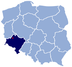
| Gmina Przemków Przemków Commune | |
|---|---|
| Gmina | |
 Coat of arms Coat of arms | |
 | |
| Coordinates (Przemków): 51°31′N 15°48′E / 51.517°N 15.800°E / 51.517; 15.800 | |
| Country | |
| Voivodeship | Lower Silesian |
| County | Polkowice |
| Seat | Przemków |
| Area | |
| • Total | 108.04 km (41.71 sq mi) |
| Population | |
| • Total | 8,329 |
| • Density | 77/km (200/sq mi) |
| • Urban | 6,107 |
| • Rural | 2,222 |
| Website | http://przemkow.pl/ |
Gmina Przemków is an urban-rural gmina (administrative district) in Polkowice County, Lower Silesian Voivodeship, in south-western Poland. Its seat is the town of Przemków, which lies approximately 19 kilometres (12 mi) west of Polkowice, and 97 kilometres (60 mi) north-west of the regional capital Wrocław.
The gmina covers an area of 108.04 square kilometres (41.7 sq mi), and as of 2019 its total population is 8,329.
Neighbouring gminas
Gmina Przemków is bordered by the gminas of Chocianów, Gaworzyce, Gromadka, Niegosławice, Radwanice and Szprotawa.
Villages
Apart from the town of Przemków, the gmina contains the villages of Jakubowo Lubińskie, Jakubowo-Węgielin, Jędrzychówek, Karpie, Krępa, Łąkociny, Łężce, Ostaszów, Piotrowice, Szklarki, Wilkocin and Wysoka.
References
- "Population. Size and structure and vital statistics in Poland by territorial division in 2019. As of 30th June". stat.gov.pl. Statistics Poland. 2019-10-15. Retrieved 2020-02-14.
| Gmina Przemków | ||
|---|---|---|
| Town and seat |  | |
| Villages | ||
| Polkowice County | ||
|---|---|---|
| Seat: Polkowice | ||
| Urban-rural gminas |  | |
| Rural gminas | ||
This Polkowice County location article is a stub. You can help Misplaced Pages by expanding it. |