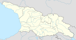
| Grigoleti გრიგოლეთი | |
|---|---|
| Village | |
  | |
| Coordinates: 42°02′13″N 41°44′21″E / 42.03694°N 41.73917°E / 42.03694; 41.73917 | |
| Country | |
| Region | Guria |
| District | Lanchkhuti |
| Elevation | 3 m (10 ft) |
| Population | |
| • Total | 286 |
| Time zone | UTC+4 (Georgian Time) |
Grigoleti (Georgian: გრიგოლეთი) is a small seaside village located on the Black Sea coast in the Lanchkhuti Municipality of Guria region of Georgia.
Geography
It is situated in the Guria lowlands, 1.24 miles (2 km) south of Poti, approximately 186.4 miles (300 km) west of Georgia's capital, Tbilisi, and just south of Kolkheti National Park. The village is 3 meters above sea level.
The area is covered by perennial pine trees, and its shoreline is known for its magnetic dark sand beach. The village's sand is said to have medicinal properties that treat hypertension, cardiovascular diseases, rheumatic diseases, and disorders of the central nervous system, among others.
Demography
According to the 2014 national Census, Grigoleti has a population of 286.
See also
References
- "Population Census 2014". www.geostat.ge. National Statistics Office of Georgia. November 2014. Retrieved 28 June 2021.
- "Georgia's five resorts of Black Sea coast you have probably never visited before". GeorgianJournal (in Georgian). Retrieved 18 June 2021.
- "Summer tours in Grigoleti". GeoFit Travel. Retrieved 2021-06-21.
- "მოსახლეობის საყოველთაო აღწერა 2014". საქართველოს სტატისტიკის ეროვნული სამსახური. November 2014. Retrieved 26 July 2016.
This Georgia location article is a stub. You can help Misplaced Pages by expanding it. |